Napoleonic War military intelligence.
A New Map of Spain and Portugal, Exhibiting the Chains of Mountains with Their Passes, the Principal & Cross Roads, with Other Details Requisite for the Intelligence of Military Operations.
$2,200
1 in stock
Description
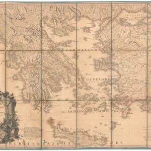
This is a large-format 1810 map of the Iberian Peninsula in four sheets, each of which is dissected and laid on linen, compiled by Jasper Nantiat and published by William Faden. It was produced at the height of the Peninsular War (1807 – 1814), a key conflict in the Napoleonic Wars, and intended for use by British officers.
The mountainous terrain of the peninsula is beautifully illustrated, while cities and towns, forts, roads, and coastal features are noted in extensive detail. A glossary at bottom explains symbols employed and provides a translation of Spanish terms and abbreviations. A table of distances between major cities is included at bottom-left. Larger towns and cities are colored in red.
An extensive note at bottom lists the earlier maps and atlases consulted in the preparation of this map, as well as information on the heights of mountains, the passes between them, and administrative divisions. Six scales are provided.
The Peninsular War began when Spain and France jointly invaded Portugal in 1807. The following year, Napoleon turned on his Spanish allies, occupied the kingdom, deposed the king, and installed a new monarchy led by his brother. These events set off a general uprising against French occupation (Levantamiento del Dos de Mayo), which continued in the following years as guerilla warfare. Meanwhile, several Spanish cities, especially Cadiz, held out amid French sieges, while a combined British and Portuguese army under the command of Arthur Wellesley (Duke of Wellington) fought the French in conventional battles. The combined regular and irregular forces wore down the French occupation, especially once resources were directed towards Napoleon’s invasion of Russia in 1812.
Although less dramatic than Napoleon’s defeat in Russia, the Peninsular War was arguably just as important to his downfall. Large numbers of French forces were pinned down for years and unavailable in other theaters. The dogged Spanish resistance was also inspirational to other peoples living under French occupation. The liberal Spanish Constitution of 1812 demonstrated that liberal reforms could be enacted outside of the Napoleonic system, though absolutist forces continued to resist these changes for decades in a protracted civil war. The war was socially and economically devastating to both Spain and Portugal, and although their sovereignty was secured their overseas empires were greatly diminished as a result.
Cartographer(s):
William Faden (1749 – 1836) stands out as one of the eminent English cartographers and map publishers of the late 18th and early 19th centuries.
Early in his career, Faden was mentored by Thomas Jefferys, a leading map engraver and publisher in London, who held the distinguished title of “Geographer to the King.” Upon Jefferys’ death in 1771, Faden inherited his business, and by 1783, his exceptional skills earned him the appointment as the royal geographer to King George III.
His cartographic prowess was particularly evident in his detailed maps of the British Isles and depictions of battles during the American Revolution. In addition to his cartographic ventures, Faden was a shrewd publisher, running a renowned map store in London. This establishment quickly became a nexus for geographers and explorers.
Condition Description
Large topographically detailed engraved case map in four sections, each segmented and mounted to original linen with printed Faden labels and vellum tabs pasted to versos.
Original hand-color in outline; light offsetting else fine; housed in publisher's moderately worn marbled slipcase with printed paper title label.
References