1832 Brué map of the United States prior to decades of dramatic westward expansion.
Carte générale des États-Unis, du Haut et Bas-Canada, de la Nouvle. Ecosse, du Nouvau. Brunswick, de Terre Neuve &a.
$350
In stock
Description
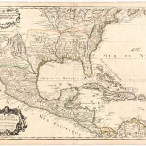
This topographical map of the United States, as it appeared in 1832, was produced and published by the Parisian engraver and mapmaker Adrien Hubert Brué (1786-1832). It depicts the entire eastern seaboard, although the Florida Peninsula and the island of Newfoundland have been added as insets in the lower right corner of the map. The map was produced at a scale of 1:7000000 and measures 20 by 14 inches.
Brué represents all of the states and territories in existence in 1832, but even so, the western frontier still extends as far east as the borders of Illinois, Missouri, and Mississippi. Missouri, itself only established as a state in 1821, has been delineated alongside the Arkansas Territory, even though this would not achieve statehood until four years later.
In the lower-left corner of the map, we see the beginning of Upper Mexico, a territory that, within a few decades, would be subsumed by the United States. Texas, still part of Mexico, is labeled. So are various Indian territories. In the north, we find the French labels for Upper and Lower Canada, but the vast northern wilderness still is labeled Hudsonie, referring to the powerful Hudson Bay Company.
Cartographer(s):
Adrien Hubert Brué (1786-1832) was a French cartographer active in the 18th and 19th centuries. He was born in Paris on March 20, 1786, and died of cholera on July 16, 1832, in Sceaux.
In his youth, Brué served as a cabin boy on various ships, including aboard the Naturaliste, which was part of the Baudin expedition (1800-1804) to the South Seas and New Holland (Australia). Upon his return, he began producing maps for a grand atlas, published for the first time in 1820. A new and better atlas was issued in 1830, the same year he was appointed Royal Geographer.
Brué’s production included various atlases and unique maps, all of which were recognized for the purity of the engraving and the accuracy of the information. His main work, the Atlas universel was expanded multiple by him and Charles Picquet (whose stamp is found on most of Brué’s maps). Among the many aspects that elevated Brué above his peers was the. The fact that he drew his maps directly onto copper plates, a process which he named cartel end prototypes.
Condition Description
Excellent.
References