Merian’s spectacular view of Prague still reeling from the Swedish invasion and thirty years of religious war.
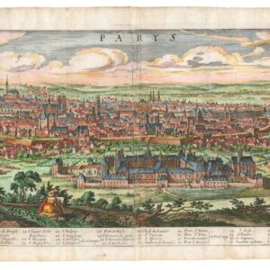
[PRAGUE] Wahrhaffte Contrafactur der Weit Berühmbten Königlichen Haupt Statt Prag in Böhmen, Wie Solche Jetziger Zeit im Wesen Steht / Praga.
$1,400
1 in stock
Description
This is Matthäus Merian’s gorgeous view of the Bohemian capital, Prague. Merian was one of the best draughtsmen of his time, and this well-constructed work demonstrates his exceptional skill.
Drawn from the hilltop that today is the Kinsky Gardens (Zahrada Kinských), we look across this historic city that is divided in two by the great Vltava River (Moldau). This river is a crucial element of the city’s history. Prague was founded along its shores, and throughout its 1200-year history, the river has provided its inhabitants with both resources and connectivity to the rest of Europe. Even though the river had always been a lifeline, when Merian composed his view, the Vltava had just saved the city from a tragic fate (see context section).
Spanning the Vltava we see a single bridge, which to this day is Prague’s most iconic monument: the Charles Bridge (Karluv Most). Since the mid-14th century, this impressive structure has connected the two banks, which consequently had developed as a single city (in contrast to, for example, Budapest). We see this division clearly in Merian’s view: On the left side, we find the monumental Hradcany area, defined by Prague Castle. During the city’s heyday as a political nexus in Europe and the capital of the Holy Roman Empire, this was where the royal residence and seat of government were found. It was also the location of Prague’s enormous Gothic cathedral, the St Vitus, whose lofty bell towers can be seen clearly in the image.
The idea was that while integrated with the city as a whole, the castle area could also function as an independent unit, divorced from the general population in times of need. A funny detail that underlines this detachment, and which can still be seen to this day, is the vineyard on Petrin Hill in front of the Castle. This, and other agricultural lands, lay within the framework of the defensive walls and could thus help sustain inhabitants during a siege (at least that was the idea). The large church farthest to the left is the still-standing Strahov Monastery, which during the late 16th and early 17th century housed one of the finest monastic libraries in the world.
Across the bridge, we find the main town, divided into the old and new towns, respectively (Stare Mesto and Nove Mesto), and crowned along the northern side by the Jewish neighborhood Josefov. The old town is clearly recognizable by the large Tyn Church (close double spires fronted by an arcaded portico), which dominates the old town square and houses the tomb of renowned Danish astronomer Tycho Brahe (1546-1601). The new town, at this stage only a few centuries old, centers on a large open space that today is Wenceslas Square (Vaclavske Namesti). The entire renaissance city is surrounded by a massive city wall. Despite these impressive defenses, Prague remained vulnerable, and the city depicted by Merian was one characterized both by trauma and a deep relief that it had survived intact.
Context is Everything
Merian’s view is important because he was one of the greatest draughtsmen and mapmakers of his day. This view of Prague is nevertheless particularly poignant and would have been so for Merian as well. When Merian published this view just before his death in 1650, all of Europe was reeling from thirty years of bloody religious wars that had encompassed most of the continent. The Thirty Years’ War (1618-48) was Europe’s way of finally coming to terms with the schism between Catholicism and the new Protestant variants – the first of which had been born out by the Bohemian intelligentsia (e.g., Jan Hus). This deep and bloody conflict raged for three decades and culminated in the siege and partial sacking of Prague in 1648.
This battle and siege, which lasted from July 25th until November 1st, 1648, was the last great event of the Thirty Years’ War. The Swedes, who had one of Europe’s most modern and powerful armies, had used the peace negotiations at Westphalia as an opportunity to mount a campaign deep into the heart of Europe. The goal was the Bohemian capital of Prague, but the motivation was rather disingenuous. Rather than religious fervor, the Swedes were driven by greed and opportunism. Most historians agree that the main aim was to loot the extensive and world-famous collection of treasures that the Holy Roman Emperor Rudolf II (1552–1612) had accumulated in Prague Castle during his reign.
The Swedes succeeded in taking Hradcany, looting enormous riches in the process, but a ferocious battle on the Charles Bridge prevented the feared Swedish soldiers from penetrating the main city on the other side of the river. This is a key event in Czech history and is depicted in a large and dramatic diorama from 1891, which one can still experience today.
Among the consequences of the Swedish sacking of Hradcany was the loss of most of Bohemia’s cultural treasures and, through that, large parts of their identity. Over the coming centuries, the German language and culture would almost completely replace the indigenous Bohemian identity. This identity – and indeed the Czech language – would only be rediscovered as part of the romantic nationalism that swept across Europe in the late 19th century.
The Czechs have always offered fierce resistance to invaders. There were good reasons for Soviet tanks rolling into Prague in 1968. This was a country and a people that needed to be controlled. After the fall of communism, Vaclav Havel, the father of the newly free nation, who also was the recipient of the Nobel Peace Prize and the new president of Czechoslovakia at the time, traveled to Sweden on one of his first state visits. Having been a decisive factor in the victory over communism and the end of the Cold War, he was in a position to ask for almost anything from the West. Much like his persona, his request was humble: on behalf of all Czechoslovak people, he asked the Swedes to return the so-called Silver Bible – the first ever printed Bible in the Czech/Bohemian language.
This book was just one of thousands of treasures that the Swedes had stolen during their opportunistic sacking of Prague more than three centuries earlier. But it was more important than most of the other because it constituted one of the earliest markers of a distinct Bohemian identity and language. Reclaiming it would mean reclaiming an important national treasure for a people that finally were free from foreign occupation. Even though Havel was among the most celebrated politicians and peacemakers in the world at the time, his humble request was shamefully rejected by the Swedes, and the Silver Bible remains in the University Library of Uppsala to this day.
Cartographer(s):
Matthäus Merian (September 1593 – 19 June 1650) was a Swiss-born engraver who worked in Frankfurt for most of his career, where he also ran a publishing house. He was a member of the patrician Basel Merian family.
Early in his life, he had created detailed town plans in his own unique style, for example plans of both Basel and Paris (1615). With Martin Zeiler (1589 – 1661), a German geographer, and later (circa 1640) with his own son, Matthäus Merian produced a collection of topographic maps. The 21-volume set was collectively known as the Topographia Germaniae and included numerous town-plans and views, as well as maps of most countries and a world map. The work was so popular that it was re-issued in many editions. He also took over and completed the later parts and editions of the Grand Voyages and Petits Voyages, originally started by Theodor de Bry in 1590. Merian’s work inspired the Swedish royal cartographer, Erik Dahlberg, to produce his Suecia Antiqua et Hodierna, which became a cornerstone in European mapping.
After his death, his sons Matthäus Jr. and Caspar took over the publishing house. They continued publishing the Topographia Germaniae and the Theatrum Europaeum under the name ‘Merian Erben’ (i.e. Heirs of Merian). Today, the German travel magazine Merian is named after him.
Condition Description
Minor reinforcement to verso centerfold, some discoloration along the bottom edge, small area of loss on bottom edge towards the right.
References
