A stunning and extremely rare advertisement for the Cunard Line’s 1950 cruise to Africa, with a stop in the new capital city of Tel Aviv.
Cunard R.M.S. Caronia / Great African Cruise 1950
Out of stock
Description
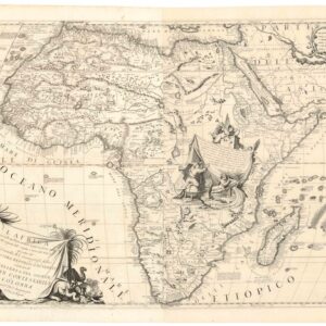
This vibrant travel poster from 1949 inscribes itself within a long tradition of integrating pictorial maps in commercial printing, especially regarding travel. This particular example of an amalgamation between map and travel poster is among the rarer and more beautiful examples and one we have not come across before.
The poster is a commercial advertisement for the British shipping company Cunard Line, which was (and continues to be) one of the largest passenger companies in the world. More specifically, it promoted a particular journey around the world on board the R.M.S. Caronia. The two-and-a-half-month voyage was to take place in 1950 and was known as the Great African Cruise because, unlike most cruises of the era, a large part of the itinerary was along the coasts of this continent.
The composition centers on a world map, with Africa centrally placed. A thin white line indicates the route that the cruise will take. The artist renders the potential experience with illustrations of places visited along the way. Thus, we see the skyscrapers of New York City – crowned by the Star Spangled Banner and fronted by the Statue of Liberty, the vaqueros and peões (cowboys) of Brazil, the volcano of Tristan da Cunha, exotic animals and ancient marvels in Africa, and a range of familiar imagery in Europe.
Part of what intrigues us about this map is its proximity to World War II, when a journey such as this would have been unthinkable. The very concept of a transatlantic, multi-continent pleasure cruise was a clear indicator that the world was healing and moving towards better times. Despite this optimistic outlook, the map still depicts an ‘old world,’ full of colonial hegemonies that soon would be gone. An important exception to that, and one that makes this pictorial map all the more interesting, is the inclusion of Tel Aviv on the route. At the time this map was printed, Tel Aviv had become the capital of a new Jewish state, no more than a year old at this stage.
At the top of the globe, and quite unrelated to the cruise itself, we find rather extensive illustrations subtly celebrating British ventures into the Arctic regions. Among the imagery, we see a polar bear on an iceberg and ships caught in the ice flows and gradually being churned into the frozen sea.
Surrounding the map is a gorgeously composed swirl of oceanic motifs, underscoring the product’s maritime nature. Large fish swim in the thrashing waves, and seagulls hover overhead as a windhead in the upper left corner foams the waters and stirs a gale. At the bottom, a cartouche reads ‘Great African Cruise 1950’.
Census
The poster was made as a color offset print measuring 21.5 by 26.75 inches. It was drawn by D.E. Bates in 1949 and printed in England, but the exact publisher and location remain obscure. We have not been able to locate other examples in institutional collections or on the open market, indicating considerable rarity.
Cartographer(s):
Condition Description
Small repaired tears, minor edge wear (small area of loss just below signature), tiny pinholes at top-left and right.
References