The most important 19th-century plan of Rome.
Pianta Topografica di Roma Pubblicata Dalla Direzione Generale Del Censo ed Aggiornata a Tutto il Corrente anno MDCCCLXVI
Out of stock
Description
The result of Rome’s first modern census.
This stunning 4-sheet wall map of the Eternal City is an essential historical document in Rome’s long history. It folds into its original red slipcase, beautifully preserved with a gilt-embossed coat-of-arms of Pope Pius IX on the cover. The map was published in 1866, the same year Pius chaired his first Vatican Council as pope.
The map results from Rome’s first modern census and precedes the city’s elevation to Italy’s new capital. A first state was engraved and published in 1829 on the order of Cardinal Cesare Guerrieri. Guerrieri was the president of the congregational council established in 1818 to meet Pope Pius VII’s call to count the citizens of Rome. Known as the urban cadastre (formal censuses were not instigated in Italy until 1871), the process was a massive undertaking that took four years to complete (1822).
Guerrieri ordered that the many hand-drawn maps compiled and used in the counting process be combined into a single great plan of Rome, prompting the first state of this iconic map. A second state was then published in 1854, which built on the original plates but added new urban elements, such as the iron bridge next to Ponte Rotto. Twelve years later, the map was amended again, this time with far more significant updates.
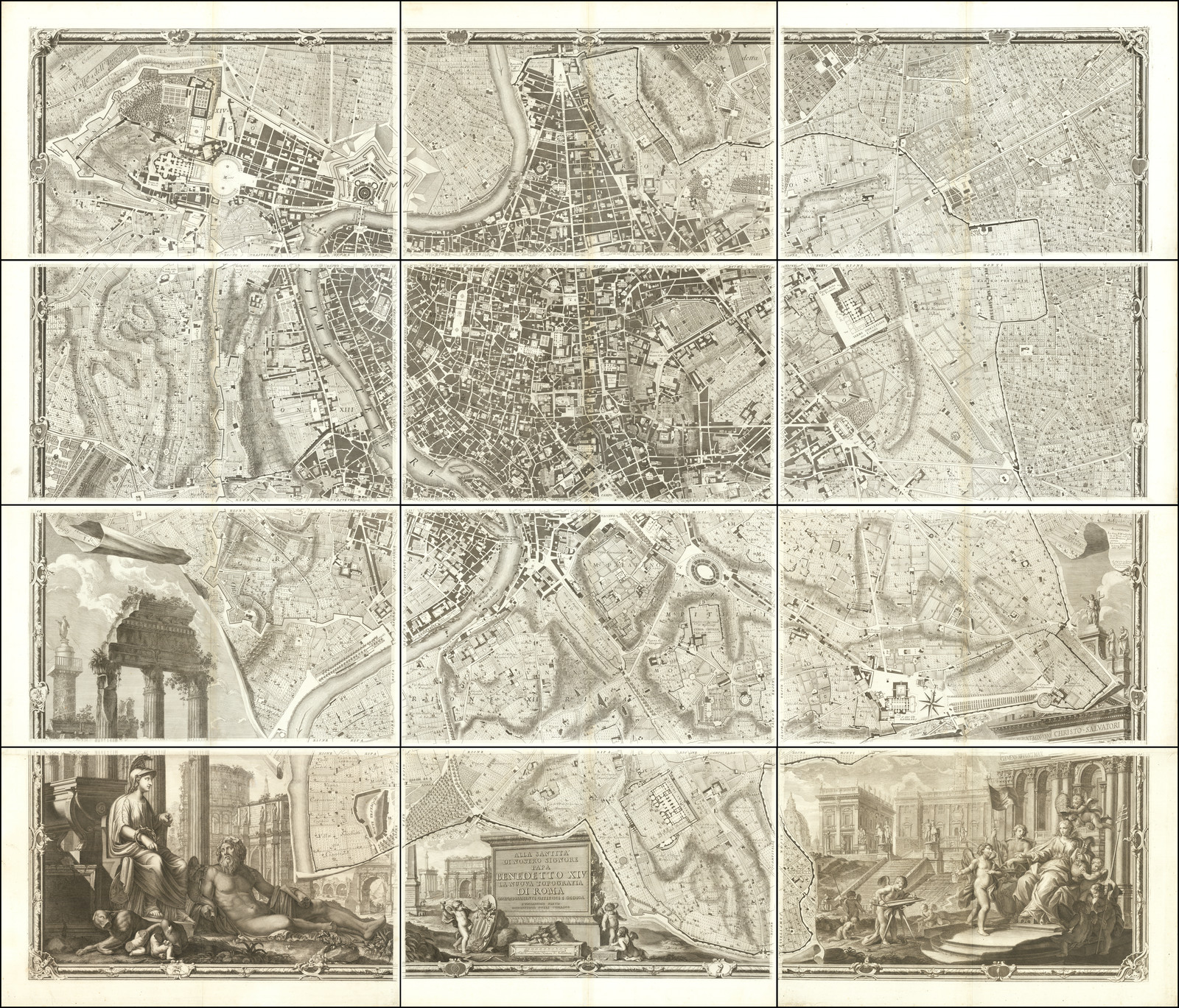
The map is oriented to cardinal directions, with north at the top. It quickly became renowned for its accuracy and detail, with even the finest features appearing clearly. Many of the mapping techniques applied in this map were originally pioneered in the monumental and genius city plan published by Giambattista Nolli in 1748. Like Nolli’s iconic creation, this map applies a technique of hachuring and color-coding elements that allow viewers to easily distinguish buildings from open spaces like streets and piazzas.
In our map, buildings are illustrated as hatched spaces, while streets and piazzas are left uncolored and thus contrast sharply with the architecture. The plan includes most of Rome’s many historical monuments but focuses on the many churches scattered throughout the city. During the Baroque period (c. 1600-1800), most of Rome’s active churches were increasingly interconnected by the urban infrastructure so that streets almost seem like arteries, leading from one church to the next. The city’s most famous monuments are shown as architectural top plans, once again evoking the brilliant legacy of the Nolli Map.
The current example is the third and final state of this map, which is also the most accurate depiction of Rome created in the 19th century. Many features not only identify our copy as the 1866 edition but also demonstrate how up-to-date this latest version really was. We see new additions to the city, such as the first stretch of the Via Nazionale, which was only completed the same year this map was published. Modern elements, such as railroads, have also appeared on this final state of the map, with the train lines to Termini clearly shown (completed in 1862), while the Passenger Hall – built only in 1867 – does not figure on the map. Other details include the iron bridge on San Giovanni dei Fiorentini (built in 1863), Piazza Matai (1864), and the associated tobacco factory (1863).
Census
Copies of this map exist in Italian municipal archives, including those in Rome and the Achille Bertarelli archives held in Milan: (https://graficheincomune.comune.milano.it/graficheincomune/risultatoricerca.aspx?appIndex=25&mode=0&openDetailMode=0#&&hsp=RRVM_DET-1-10-61506).
The OCLC does not list any institutional holdings of this important map, and only a single example of the 1866 edition of this map has been offered on the private market in recent years.
Cartographer(s):
Condition Description
Four sheets, joined as issued. Segmented and laid on linen, with original gilt embossed slipcase, with coat of arms of the Pope. Minor toning and soiling.
References
Related products
-
-
Add to cart


- Europe, Italy, Bird's-eye-views
Venetia.
- $3,500
-
-
-


![Dalmatia maritima [2 sheets].](https://neatlinemaps.com/wp-content/uploads/2024/08/NL-02219-merged_thumbnail-300x300.jpg)