The most widely emulated map of colonial North America, with one of the earliest views of New York City.
Recens Edita totius Novi Belgii, in America Septenrionali siti, delineatio cura et sumptibus
$4,000
1 in stock
Description
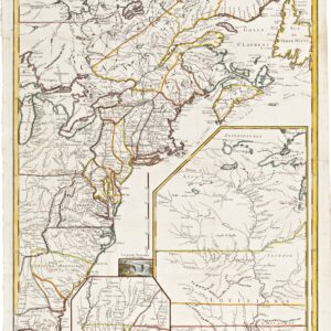
A splendid example of one of the most pirated maps of the 17th and early 18th centuries. The source map was issued in 1650 by Dutch mapmaker Joanes Jansson (Jan Janssonius) as a culmination of the Dutch survey work that had been taking place in their North American holdings. The systematic mapping of Manhattan Island was among the critical cartographic advancements incorporated in this chart. Until then, Manhattan was usually depicted as triangular in most printed maps, but Jansson gave a more accurate elongated shape. Another innovation was the plotting of Indian tribes along the coast. In general, Jansson’s map was something of a conceptual revolution in mapmaking in that it purported to include every colonial town or settlement on the northeastern seaboard in existence at the time.
Jansson’s map quickly became very popular and was soon copied by Nicholas Visscher (1651). Visscher added an early view of the Dutch settlement of New Amsterdam at the bottom of the map, making it more attractive. From then on, it became the quintessential map of New Belgium (or New Holland). It was consequently copied ubiquitously by Flemish, Dutch, and German mapmakers until the middle of the following century. Naturally, as time passed and events unfolded, some elements were updated. New Amsterdam was no longer the sleepy Dutch port rendered by Visscher but had, by the time new versions of the map were issued, grown into one of North America’s most important cities: New York.
Among the cartographers who created new editions of this seminal map was Matthäus Suetter, a German mapmaker and publisher based in the free city of Augsburg. Seutter, who had apprenticed with the eminent J.B. Homann, carved an entirely new plate based on the Jansson/Visscher original, which in turn sparked a whole new series of updated Novia Belgii editions. Neatline is excited to offer an example of the scarce third state of Seutter’s map (info on distinguishing states below).
The map shows the east coast of North America, from Virginia up to Massachusetts and Maine. At the time of its initial publication in 1730, Seutter’s map was one of the finest cartographic depictions of the East Coast, with especially the New England coastline being rendered in impeccable detail. Unlike the original Jansson/Visscher edition, Seutter’s map clearly delineated the boundaries of colonies like Massachusetts, New England, New York, New Jersey, and Pennsylvania. He also added the now-famous view of New York (entitled Neu Jorck sive Neu Amsterdam), which celebrated the brief return to Dutch governance between 1672 and 1674.
Seutter’s vista is one of the earliest available views of this great metropolis. When comparing his image with Visscher’s original depiction of New Amsterdam (compiled only 25 years after the Dutch settlement at the southern tip of Manhattan had been established), it is evident how much had happened in the 80-odd years that lay between these depictions.
The inset view of New York is placed in the waters of the Atlantic. Seutter visually enhances the insert and the title cartouche by adding an allegorical scene on top of the New York view. Here, Seutter’s patron, Holy Roman Emperor Charles VI, reclines against the outer strap work of the title cartouche while receiving three gift-bearing and divine figures from the Greek pantheon. These are Hermes, god of commerce and trade; Athena, goddess of wisdom; and, looming over a chest of gold coins, is Hera, the goddess of women, family, marriage, and childbirth. Most telling of the age in which this map was created are the many dark-skinned figures that follow these Greek gods. These African laborers or slaves (by some interpreted as indigenous rather than enslaved peoples) carry some of the goods harvested in the colonies and lay them at the emperor’s feet. While this allegory is deeply off-putting today, it was part of a broader visual culture and narrative in which the colonized world yielded its wealth voluntarily to the majesty of European rulers.
In addition to reflecting how rapidly geographic knowledge of North America developed during this period, this map offers one of the 18th century’s most spectacular renderings of the North American colonies. Not only does it include an early view of New York, but the map is filled with vignettes associated with the New World, including everything from the exotic flora and fauna to Native American architecture. It is an extraordinary historical document and a stunning visualization of a still largely undiscovered America.
States
When Seutter adapted his map from the Jansson/Visscher original by carving a new plate and making important updates, it set in motion a new and independent editor of this iconic map. Three of the six states in the edition carry Seutter’s imprint, with Neatline’s example being the third and final state bearing his name. After Seutter’s death in 1757, his son-in-law, Tobias Conrad Lotter, took over the plates and began issuing the Novii Belgii map in his own name. Lotter also issued three states bearing his name. The six states of Seutter’s Novii Belgii map can be identified as follows:
First State (c. 1730): Matthias Seutter is listed as mapmaker under the map’s title. The words “Chalcographi Augustani” is shown as the place of publication, but there is no mention of Seutter’s appointment as imperial geographer to Charles VI.
Second State (c. 1740): Seutter’s title and the place of publication have been updated to reflect his new position: “Sac. Caes. Maj. Geographi August. Vindi.”
Third State (c. 1750): Two extra lines of text have been added under the publisher’s imprint: “Cum Gratia et Privil. S.R. I. Vicariat, in part, Rheni, Sueviae, et Juris Franconici.”
Fourth State (c. 1758): First state where Lotter is listed as the mapmaker (Tob. Conr. Lotteri). The town of “Briston” (Boston) is added.
Fifth State: Briston is corrected to Boston.
Sixth State: “S.A.L.A.” is added after “August Vindi” in the imprint.
Census
Due to this map’s many variations, establishing an exact census for each state and edition is difficult. Nevertheless, the OCLC notes at least one example of the third state of Seutter’s map in the Bibliothéque national de France (no. 951175602) and the Bayerische Staatsbibliothek in Munich and the Deutsches Historisches Museum in Berlin (no. 159823469). While it is more common to find the later Lotter editions of this map on the one market, examples of a Seutter original do surface on occasion.
Cartographer(s):
Matthäus Seutter (1678-1757) was one of the most important and prolific German map publishers of the 18th century. As a young man, he was an eminent engraver who had been trained under the great Johann Baptist Homann in Nürnberg. In the mid-1720s, he moved to his hometown of Augsburg and set up his own printing and publishing house, specializing in maps. His skill as a cartographer was soon noticed in higher circles, and in 1732 Seutter was appointed Imperial Geographer to Holy Roman Emperor Charles VI. The appointment came after his most famous cartographic publication, the two-volume Atlas Novus Sive Tabulae Geographicae, from 1730.
Like many of his contemporaries, Seutter drew heavily on other mapmakers when compiling his charts. Among his primary sources were the maps of his mentor Homann and the great French cartographers Guillaume Delisle and Nicolas de Fer. When Seutter died in 1757, his son-in-law, Tobias Conrad Lotter, took over the firm.
Condition Description
Margins extended on all sides without loss of image. Expert later color, verso with manuscript architectural plan, showing through in places
References
The keeper of maps at the British Museum, Tony Cambell, has written extensively on the Jansson/Visscher map and its adaptations: Tony Campbell (1980). The Jansson-Visscher Maps of New England, in The Mapping of America, by R.V. Tooley.