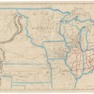
Brué’s important map of the United States prior to the Mexican-American War, with a blatantly independent Texas.
Carte Générale des Etats-Unis, des Haut et Bas-Canada, de la Nouvelle Ecosse, du Nouvelle Brunswick, de Terre Neuve.
$875
In stock
Description
Iconic French map of the United States before winning Texas and the West.
This map by French Royal Geographer Adrien-Hubert Brué captures the United States in an early form. It is a window into our country as it appeared during the short years while Texas was an independent republic (1836-46) and before the United States won its westernmost third.
Brué carefully delineates the east coast of North America, including Nova Scotia, New Brunswick, and the southern coastline of Labrador and Newfoundland (the latter has also been included in its entirety in a small inset in the lower right corner). To the south, only the northern half of Florida has made it onto the map proper, yet the entire panhandle is depicted using an inset to cover its southern half.
Focus is generally on the continental United States, as evidenced by the far higher density of toponyms, infrastructure, occupation, and other features within her borders. Important frontiers, such as the Great Lakes, are depicted in impressive detail. Among the aspects Brué is recognized for was the careful inclusion and labeling of America’s interior rivers and the correct delineation of tribal territories.
The current state is the so-called 2nd edition from 1840, printed in an update to Brué’s already famous Atlas universel. Brué felt that conditions had changed so drastically that it warranted a new state (partly explained in the text in the lower left corner of the map). However, the United States was still in the middle of an enormous political reconfiguration that would redraw most of the continent’s borders. Importantly, we see evidence of this massive reconfiguration in Brué’s explicit delineation of an independent Texas (note the definition in the legend). Within six years of the publication of this map, Mexico and the United States would be at war with each other, a war that would culminate in Mexico’s relinquishment of not only Texas but also California and the entire Southwest.
Context is everything
Adrien-Hubert Brué was a Royal Geographer during the July Monarchy (1830-1848), in which Louis Philippe I reigned as King of France—this period of relative calm followed the massive social upheavals of the French Revolution and the subsequent Napoleonic Wars.
As a geographer to the King, Brué produced several important maps and charts. Still, his most successful endeavor was the Atlas universel de géographie physique, politique, ancienne et moderne, from which this map derives. The original edition of the expanded atlas was issued in 1830, but a decade later, a second and enlarged edition was published. This edition saw several significant changes made to many of the maps inside – especially those about North America. Our double-page rendition of the early United States comes from this enlarged second edition of the atlas.
The current map is a snapshot of America during one of the most formative decades of its history. Brué captures these changes both elegantly and efficiently, but then he had lived through similar times in his native France, witnessing firsthand the horrors of the French Revolution and the subsequent militaristic ambition of Napoleon Bonaparte. It is an excellent cartographic capture of America’s political landscape in the late 1830s.
Census
The map was published in the second and enlarged edition of Brué’s Atlas universel de géographie physique, politique, ancienne et moderne in Paris in 1840. This edition of the atlas included 68 engraved maps, of which 67 were double-page sheets. His maps were drawn directly onto the copper printing plates, and most of the sheets were subsequently hand-colored in outline. The atlas covered contemporary and historical geography, including maps of Alexander the Great’s Empire or the Route of Exodus.
The atlas was published multiple times and in different versions between 1820 and 1875. The first enlarged version of the atlas was issued in 1840, the edition from which our map derives. The OCLC lists an individual example of the 1832 state with the Bibliothèque national de France (no. 1389154218). The 1840 state, or 2nd edition, is held by the university libraries at Texas A&M and Baylor (no. 1198605092) and the David Rumsey Collection (no. 727082385).
Cartographer(s):
Adrien Hubert Brué (1786-1832) was a French cartographer active in the 18th and 19th centuries. He was born in Paris on March 20, 1786, and died of cholera on July 16, 1832, in Sceaux.
In his youth, Brué served as a cabin boy on various ships, including aboard the Naturaliste, which was part of the Baudin expedition (1800-1804) to the South Seas and New Holland (Australia). Upon his return, he began producing maps for a grand atlas, published for the first time in 1820. A new and better atlas was issued in 1830, the same year he was appointed Royal Geographer.
Brué’s production included various atlases and unique maps, all of which were recognized for the purity of the engraving and the accuracy of the information. His main work, the Atlas universel was expanded multiple by him and Charles Picquet (whose stamp is found on most of Brué’s maps). Among the many aspects that elevated Brué above his peers was the. The fact that he drew his maps directly onto copper plates, a process which he named cartel end prototypes.
Charles PicquetCharles Picquet (1771-1821) was a French cartographer especially celebrated for his collaborations with Adrien-Hubert Brué.
Condition Description
Very good.
References