Henley’s revolutionary 1976 thematic map of homosexual San Francisco — a testament to the city’s progressive track record for tolerance and inclusion.
Tails of the City Alligator Oz The land of Make-Believe.
Out of stock
Description
This rare, humorous, and iconic poster from 1976 was the first pictorial map to portray San Francisco as a ‘gay paradise.’ While such a term may seem antiquated today, in the 1970s, homosexuality was generally still considered sinful and condemned. Having a place in the world where this was different, where two men could walk hand in hand or even kiss in public, was nothing short of a radical re-thinking of social morality. In many areas of the country, homosexuality remained legally and often even violently opposed. Yet, for some reason, San Francisco was different. Perhaps it was due to its detachment from the ‘old world’ of the east coast states, or maybe it was simply that an industrious and resilient population was focused on building up rather than tearing down. Whatever the case, by the middle of the 20th century, San Francisco was known as a progressive city: a place with its eye on the future rather than the past.
A new class of contemporary niche artistry arose within this strange theatre, and a flamboyant writer and illustrator, Jesse Clark Henly, stepped onto the center stage. For most of his short life, Henly worked either from his hometown of San Francisco or in the bustling metropolis of Los Angeles. He compiled this cartoon-like rendition of the ‘City by the Bay’ just as his popularity began to take off in the late 1970s. His depiction of the city as a paradise for homosexual men was revolutionary. While the tolerance exercised in San Francisco had been well-established since at least the flower power period of the late 1960s, nobody had ever considered marketing a city based on its openness to what was then considered a ‘deviant sexual identity.’ This pioneering element made Henley’s map iconic, and it was recognized as a stroke of both artistic and branding genius within the broader community of illustrators and graphic artists.
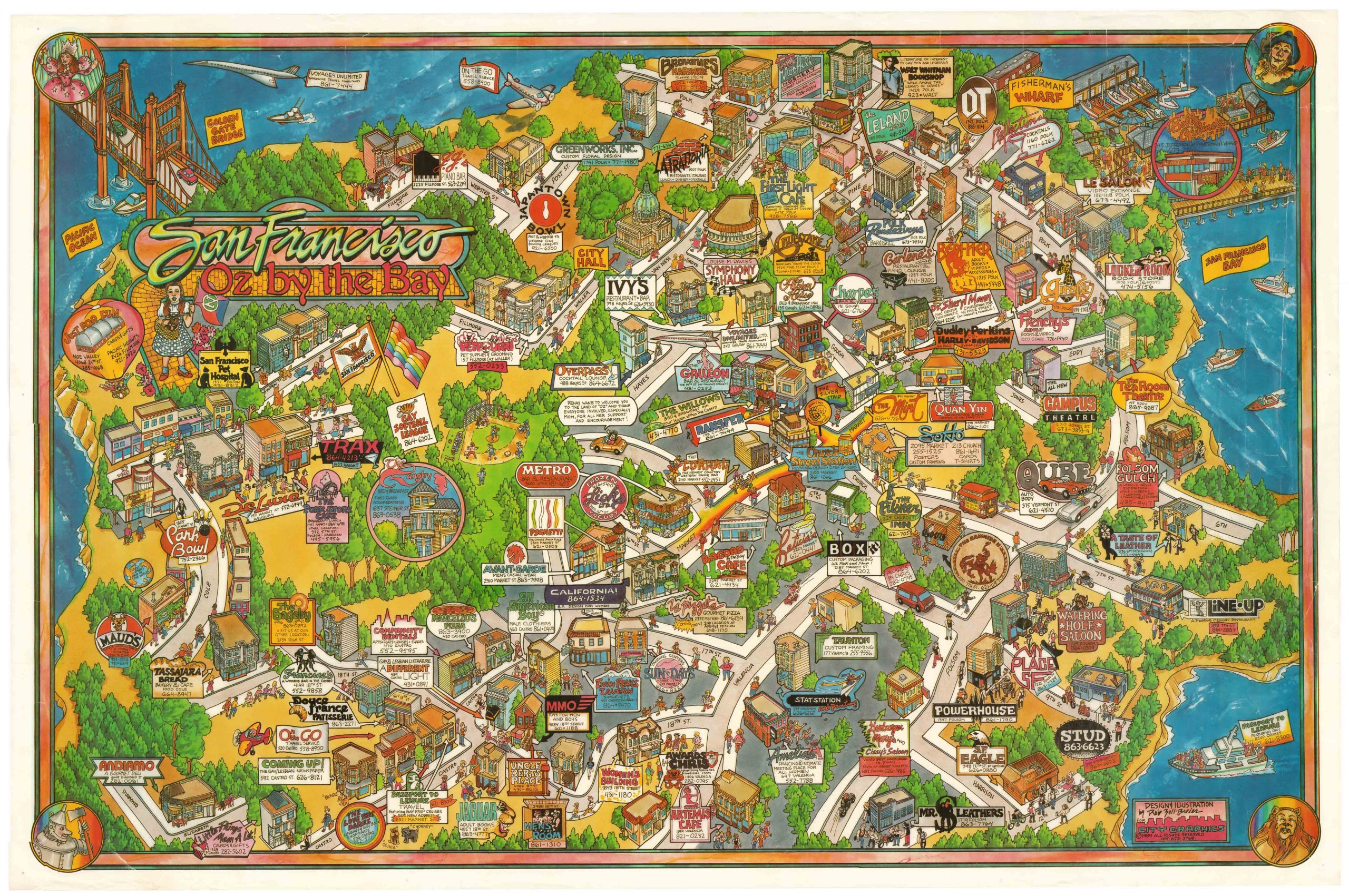
The map depicts the northern top of the SF peninsula, with the San Francisco Bridge, Alcatraz Island, and the Bay Bridge visible. Provocatively, many of San Francisco’s most notable features have been drawn ostentatiously phallic, with buildings, islands, lighthouses, windmills, public busses, and even a shark all appearing distinctly penile. Iconic San Francisco landmarks, such as the Transamerica Pyramid, the row of Painted Ladies, the Palace of Fine Arts, and City Hall, are visible and set within this humorous and highly sexualized landscape.
The city is void of humans, but certainly not of life. All of the poster’s inhabitants are alligators, many of them displaying a range of – for the time – unusual thoughts and inclinations. The choice of this particular animal as a representation of gay men is perhaps not strange. Its elongated face is used to make explicit connotations, but the more elegant layer to this character choice is, of course, in the phonetic play on the central syllable in the word (alli-GAY-tor). The ‘unusual inclinations’ pursued by our alligator inhabitants manifest themselves in many ways. We see it in their dress: several of the alligators are dressed in drag, for example; we see it in their actual activities: frolicking and enjoying themselves physically in other ways as well; but most of all, we see it in their sometimes salacious thoughts and comments, which are included on the map throughout.
While it will be no surprise that a cartoon map has a distinct element of satire embedded in it, such satire is usually not launched by a member of a minority group against the group themselves. In this case, many of the alligators come off as narcissistic, sad, or simply lost. In Golden Gate Park, we find a lone alligator in melancholic contemplation, telling himself: “I’m so different, so unique, so alone.” Not far away from him is another lone alligator apparently consumed by the exact same thought. Closer to the Gold Gate Bridge, just south of the Presidio, we see a row of townhouses in which all of the occupants participate in a joint chorus line hollering: “Oh happy day, we don’t have wives who need their hair done, or children who need their stocking filled, so we can need Bill Blass, Vidal Sassoon, Elsa Peretti, and Wilkes Bashford, not to mention a complete collection of toys from Leather Forever.”
Henley’s iconic map of San Francisco as a gay paradise is crucial evidence documenting how the city was one of the first to discard old bigoted views of homosexuals as mentally ill and abhorrent before God. Instead, she embraced all of her citizens as worthy and valuable members of the community. At least that was the ideal. And even if everybody did not always live up to this ideal, it was undoubtedly a better place for an openly gay man to live in the 1970s than almost any other city in continental America. Yet the map is not just unique because of its historical importance as a political statement or piece of activist art, but also because it is just fun. New and incredible details appear every time one takes a closer look. It is a genuinely remarkable sheet that testifies San Francisco’s legacy of tolerance and love.
Census
Even though J. Clark Henley issued the map in 1976, and presumably, in a significant number, almost no copies of this extraordinary poster seem to have survived. There are no references to institutional holdings in the OCLC, nor does it figure in any established map collections in the United States.
Context is everything
At least since the flower power movement of the 1960s, San Francisco has had a reputation for being more open and tolerant than the rest of the United States. This legacy continues until today, where SF – for better or for worse – still stands as one of the most progressive cities in the entire country. Yet the open-mindedness of San Franciscans is not a new thing. Ever since the California Gold Rush, the inhabitants of San Francisco have been less swayed by orthodoxy and tradition than by the potential of a great future and each person’s right to make their dent in it.
During the tumultuous 1960s, many of the sensibilities of the broader public changed significantly. While this included a much more liberal view of sex, homosexuality was a topic that remained highly taboo in many parts of the country. This openness meant that even a decade later, San Francisco was probably the only place where a map such as this could have been produced and sold.
Many historians view the development of LGBTQ culture in San Francisco as originating from the Gold Rush. We all know how the population of San Francisco exploded in the years around 1849-50, and estimates suggest that circa 95% of this incoming population was male. The combination of great and sudden wealth with the old trope that the rules did not apply in the West gave the city a particular indomitable spirit and lent much greater leeway to phenomena that were harshly judged elsewhere. This trend was exacerbated after the First World War when known homosexual sailors were discharged in port cities like San Francisco and New York. Rather than returning to the mental and sexual confines of their hometowns, many of these openly gay men stayed in the cities and started building their own cultures and communities.
Over the following decades, these communities became more and more established, and by the 1930s, San Francisco was renowned for its openly gay community. The fact that a degree of ‘sexual deviancy’ was accepted in San Francisco naturally caused many others from America’s hidden LGBTQ population to relocate here. As a result, San Francisco has been at the forefront of LGBTQ communities’ battle for rights and recognition for almost a century. During the hippie era of the late 1960s, San Francisco was often referred to as the ‘Gay Mecca.’ In 1978, just two years after our fantastic poster was issued, the Twin Peaks Tavern became the first openly gay bar in America.
Cartographer(s):
Jesse Clark Henley (May 10, 1950 – August 20, 1988) was a writer, model, and artist from San Francisco. He established both his career and his persona there during the 1970s. During this time, Henley created the famous Alligator Oz map of SF as a ‘gay paradise’ and started work on his iconic book ‘The Butch Manual,’ which came out in 1982. In 1979, Henley moved to Los Angeles with the ambition of further pursuing his career as a writer and artist, but like many of his contemporaries in the 1980s, he soon came in contact with AIDS. When Henley was diagnosed with HIV in 1986, he returned to his native San Francisco, where he resided until his premature death in 1988.
Condition Description
Very good.
References
