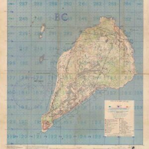
Locally-published survey of regional Sri Lanka.
Ceylon Survey. Nuwara Eliya.
Out of stock
Cartographer(s):
Survey Department of Ceylon
Date:
1917
Place:
Colombo, Sri Lanka
Dimensions:
75.5 x 61.5 (29.7 x 24 in)
Add to Wishlist
Add to Wishlist
Description
A nice map of the Nuwara Eliya region of Sri Lanka, drafted by the Survey Department of Ceylon and published in the capital city of Colombo. Already by the time of the map’s creation in 1917, Ceylon had a long tradition of advanced survey work; Ceylon was ceded to the British in 1796, and the Survey of Ceylon was established in the year 1800.
The map depicts roads, buildings, institutions, and natural features in the landscape. At bottom center is Lake Gregory, an important reservoir built by the British.
Cartographer(s):
Condition Description
Linen-backed folding map. Very good.
References