A rare window into the operational thinking behind Hitler’s Atlantikwall.
Wehrmacht Sonderausgabe VI-1940: Einheitsblatt Nr. 29 [Caen] & Einheitsblatt Nr. 30 [Lisieux].
$3,500
1 in stock
Description
Wehrmacht double-sheet map of Caen–Lisieux (1940), richly annotated in preparation for defending Normandy’s coast during the Second World War.
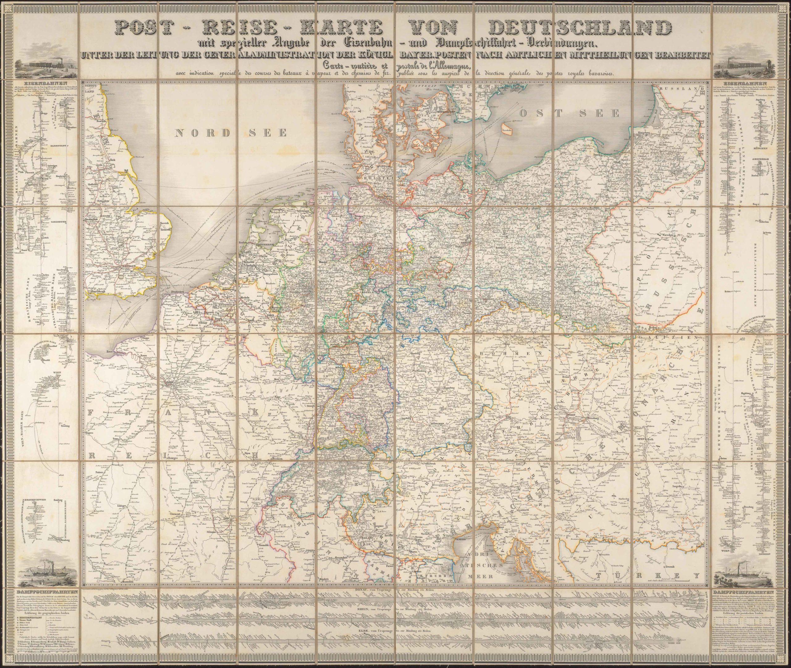
This German military topographic map of the Normandy coast between Caen and Lisieux was printed in 1940 as a Sonderausgabe (special edition) for the Wehrmacht, and later extensively annotated in colored inks during the war, almost certainly in connection with the defence of the Atlantikwall and the anticipated Allied landings of 1944.
Derived from pre-war French Carte d’État-Major surveys, this Frankreich 1 : 80 000 Sonderausgabe VI 1940 sheet was hastily re-engraved and overprinted for the German Army High Command (OKH) as part of the Heereskarten series. The base map shows coastal topography, relief by hachures, road and rail networks, settlements, and drainage—ideal for operational planning at division or corps level.
Handwritten annotations and inked operational overlay
The double sheet carries a tactical/logistical field overlay drawn in colored inks and written in the German Army’s standard abbreviated field hand. The annotations include a handwritten legend in the waters of the Channel, defining a variety of lines and symbols as wartime features of the landscape:
1. Red symbols read as: Feldlazarett (field hospital); Ortstaz. or Ortsstützpunkt (a self-contained defensive node, usually centred on a town, hamlet, or crossroad); Hauptverbandplatz (central dressing/triage station), Leichtverwundet-Sammelplatz (collection point for lightly wounded), and a circular symbol for Wagenhalteplatz (wagon assembly point).
2. Green indicates Vet. Comp. or Veterinär-Kompanie (Veterinary Company) and Pferde-Sammelpl. (horse collection point).
3. Yellow and black annotations indicate Verpflegungs-Ausgabestelle (rations and supply point) and Strassen für den Nachschub (roads for resupply).
4. A dashed yellow line is labeled “Nördlich davon Räumung bei Angriff von See“ (North of this evacuation in the event of attack from the sea), suggesting a contingency/limit line in preparation for a coastal attack.
Additional annotations on the map proper identify a range of in-field features of which army commanders needed to be aware.
Inland, a network of red lines and boxed symbols delineates defensive belts, assembly routes, and what appear to be regimental/sector boundaries and field-medical nodes, as defined by the legend. Blue ink notations appear at nodal points, presumably local command posts, artillery control points, or harbor/battery positions. Blue is conventionally used to mark friendly commands or engineer points. A dashed yellow line crosses the map, running inland and roughly parallel to the coast, indicating the Germans’ withdrawal lines or the northern limit to be held in case of a landing. A contiguous line of small circular or ringed symbols in black runs along the shoreline. These correspond to anti-landing obstacles and are consistent with other contemporary Wehrmacht notations for coastal defenses.
In general, the presence of feeding and supply points, horse assembly points, and demarcated “roads for resupply” indicates that the map was used to plan medical evacuation, supply distribution, and interior movement in support of coastal defense. Taken together, the handwritten schema reads as an operational overlay prepared by German staff (division/korps level) concerned with the immediate defense of the Caen/Lisieux coastal sector and the handling of casualties and supplies in the event of an amphibious operation.
Sheets like these are essential primary evidence because they record the Wehrmacht’s appreciation of local terrain and logistics. In this case, it revolves around identifying likely landing zones and corresponding defensive dispositions, as well as the practical problems (medical evacuation, supply, troop movement) the German Command was facing. The annotated overlay bridges topography and operational doctrine, thereby illuminating how the Atlantikwall was not only a line of concrete but also an integrated system of positions, communications, and logistical plans.
Context is everything: Hitler’s Atlantikwall
Between 1942 and 1944, Nazi Germany undertook the construction and organization of an extensive system of coastal defenses called the Atlantikwall. It ran from northern Norway to the Spanish border and evolved from ad-hoc coastal defenses into a layered system of concrete bunkers, artillery casemates, minefields, antitank obstacles, and fortified command posts intended to prevent or blunt an Allied amphibious invasion of continental Europe.
After the fall of France in June 1940, the German High Command still considered the possibility of an Allied counter-invasion launched from Britain. Early in 1940, Hitler’s planners temporarily planned an invasion of Britain (Operation Sea Lion). Whether or not a cross-Channel invasion would be launched, German commanders sought to deny the Allies easy re-entry to the continent. From 1941 to 1942, this strategic threat, combined with the need to protect U-boat pens, naval bases, and key ports, led to orders to strengthen coastal defenses. The work was intensified under Organisation Todt and the Reich’s civil and military authorities. Hitler’s Directive No. 40 formalized the priority of improved coastal defense. The project was unevenly implemented, with sectors such as Pas-de-Calais, Normandy, and the Channel ports being heavily fortified, while others were barely altered. Work was completed only in 1943–44 as an emergency response to the growing Allied build-up.
Census and publication information
The map was produced by the Heeresvermessungswesen (Army Survey Service) and printed by the Heeresplankammer in Berlin. These institutions were responsible for standard Heereskarten and for Sonderausgabe issues, adapting existing foreign cartography for German military needs.
Annotated Sonderausgabe sheets of this type are rare. Standard printed examples survive at the Bundesarchiv-Militärarchiv, the Imperial War Museum, and the Normandy Air Museum, but field-annotated operational copies are seldom encountered outside institutional holdings.
The present example, preserved with its full legend and operational markings, is thus a unique primary document of German staff cartography on the eve of D-Day.
Cartographer(s):
The Heeresvermessungswesen (or German Army’s cartographic services), was the organization responsible for wartime and thematic operational overlays, including the iconic topographic series known as Heereskarten. The service played a central role in producing both standard and special-issue maps during the Second World War.
Condition Description
Good. Wear and some loss along fold lines and at fold intersections. Creases at top-left corner. Annotations throughout. Paste-down at top-right.
References