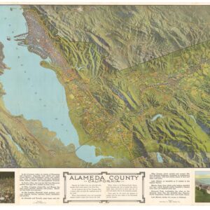
A fantastic 1920s map of Alameda.
Map of Alameda and East Bay Cities.
$775
1 in stock
Description
An attractive hand-colored map of Alameda, California, produced by Thomas Bros. in 1927.
This map captures Alameda at a point of transition. After many decades of dredging and other engineering work, the estuary between Oakland and Alameda (Inner Harbor) was made usable. The island became the site of a range of industrial and public works projects, residential developments, and attractions, including Neptune Beach, on the island’s south side, advertised at the top-left. The amusement park, which included rides, swimming pools, arcades, and live entertainment, operated from 1917 to 1939 and was often referred to as the “Coney Island of the West.”
Alameda was connected with the rest of the East Bay and with San Francisco via train lines, streetcars, and ferries operated by the Southern Pacific Railroad, which maintained a large maintenance yard and a mole (just beyond the scope of the map) on the island’s west side.
Other features of note include the artificial Government Island (now Coast Guard Island) between Alameda and Oakland, the large property belonging to the Regents of the University of California (operated as an airfield starting in 1929), and an early appearance of the Posey Tube (here as ‘Estuary Tube’), which opened to traffic the following year. The tube, which is still operational, was a significant improvement over the bridges between Oakland and Alameda, which were prone to being hit by passing ships.
The recto map is surrounded by advertisements, as is a larger indexed street map of the East Bay between El Cerrito and San Leandro on the verso. The verso also includes five inset maps in the margins, displaying driving routes between Oakland and Sacramento, Sacramento and Lake Tahoe, and three successive maps displaying driving routes between the Bay Area (Sausalito) and Eureka in Humboldt County.
This map was prepared by Thomas Bros. in 1927. Although several Thomas Bros. maps of the East Bay from the period appear in the OCLC, this particular map does not.
Cartographer(s):
Thomas Bros. Maps, the publishers of the Thomas Guide, previously known as Popular Street Atlas, Street Guide, and Popular Atlas, was started in Oakland, California, in 1915 by cartographer George Coupland Thomas and his two brothers, who were business partners. Early publications were detailed block maps, bird eye view of communities, road & highway maps, and what would be generally referred as generalized tourist maps.
Condition Description
Hand watercolor. Toning in the bottom-right quadrant and along centerfold.
References
![[Oil Painting of Lake Merritt, Oakland]](https://neatlinemaps.com/wp-content/uploads/2024/05/NL-01966_thumbnail-300x300.jpg)