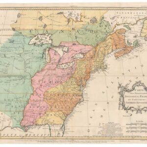
The Republic of Texas at its fullest extent, with large Iowa and Wisconsin Territories.
United States and Texas.
Out of stock
Description
A fine example of William and Alexander Keith Johnston’s c. 1843 map of the United States of America and the Republic of Texas that appeared in their The national atlas of historical, commercial, and political geography.
Cities and towns, roads, railroads, rivers, canals, lakes, and other features are indicated throughout. The borders between states, territories, and countries are outlined in hand-color. The Republic of Texas is displayed at its fullest extent, with a northern border along the Arkansas River and a panhandle extending into what is now Colorado, near Pikes Peak.
Also notable are the large Iowa and Wisconsin Territories. The state of Iowa entered the Union in December 1846 along its current borders, while the northern portion of the territory remained unorganized and its status uncertain. Similarly, when Wisconsin became a state in May 1848, a northern portion of the previous territory between the Mississippi and St. Croix Rivers was left in limbo. This situation persisted and caused considerable confusion and political squabbling, including the election of competing Congressional delegations to Washington, D.C., until the creation of the Minnesota Territory in 1849.
Both Greenwich and Washington, D.C. are employed as Prime Meridians. Below the title are scales and explanation of symbols employed. Text at right describes the composition of the Union and the division between free and slaveholding states. An inset map of the Niagara River appears at top-left, with notes from a paper by British geologist Charles Lyell, who was one of the first geologists to research the falls in depth.
The map is undated, but can be assumed to have been published between 1843 and 1845. Aside from the Republic of Texas, the reference to Florida as a territory suggests that the map dates from 1845 or earlier, while the note at bottom about the foreign recognition of the Republic of Texas and the reference to Lyell’s research suggest a date of 1843 or later.
Independent Texas
The Republic of Texas was a sovereign nation in North America that existed from March 2, 1836, to February 19, 1846, although Mexico considered it a rebellious province during its entire existence. The region of the Mexican state of Coahuila y Tejas, now commonly referred to as Mexican Texas, declared its independence from Mexico during the Texas Revolution in 1835–1836, when the Centralist Republic of Mexico abolished autonomy from states of the Mexican federal republic. Texas was annexed by the United States on December 29, 1845 and was admitted to the Union as the 28th state on that day, with the transfer of power from the Republic to the new state of Texas formally taking place on February 19, 1846.
Cartographer(s):
William and Alexander Keith Johnston were Scottish brothers based in Edinburgh who operated a prominent map engraving and printing business in the mid-19th century. A.K. Johnston was the driving force behind the business and remained in the world of cartography throughout his life, while William later entered politics, serving as the Lord Provost of Edinburgh and being knighted for his service. Johnston’s maps and atlases earned high praise for their accuracy and comprehensiveness (A.K. Johnston was strongly influenced by Alexander von Humboldt).
Condition Description
Toning along edges. Light foxing on verso.
References