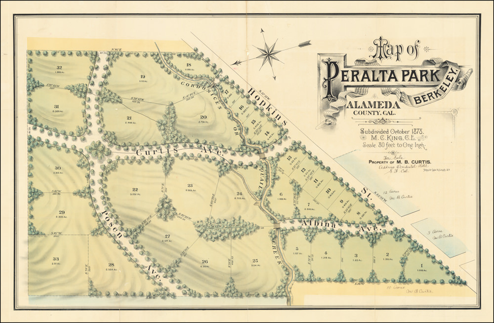
A fascinating and highly-detailed 1878 map of the East Bay.
Map of Oakland, Berkeley, and Alameda.
$2,200
1 in stock
Description
Large-format maps centered on Oakland began to appear in the 1870s. Many were linked to William J. Dingee, the so-called “Cement King,” one of the dominant California businessmen of his era. Dingee’s wealth came from real estate and water rights, and thus, it is no surprise that the map meticulously details the names of property owners throughout the area. In doing so, it provides a snapshot of the East Bay’s complex settlement history at a time when it grew dramatically.
Coverage ranges from what is now Albany to Fitchburg and inland into the hills, which became essential to the water supply of the growing towns below. Property lines and owners are marked throughout, along with streets (some ghosted in and therefore planned rather than actual), rail lines, waterways, docks, wharves, racetracks, industrial works, and several institutions, such as the “State University” (University of California Berkeley), Mountain View Cemetery, and the Asylum for Deaf, Blind, and Dumb.
Temescal Creek runs down the hills from the Contra Costa Water Company reservoir, flowing southwest towards the Bay. However, before it reached the shore, the creek was directed into an underground culvert beneath a feature labeled ‘Oakland Trotting Park.’ This was a mile-long racetrack, built in 1871 by Edward Wiard, at which gambling was legal. Much of the old Trotting Parkland now comprises the campus of Pixar Animation Studios. In 1896, the town of Emeryville (named for J.S. Emery, the president of the California and Nevada Railroad) was incorporated, and the racetrack fell within the limits of the new town.
Adjacent to the Oakland Trotting Park, between it and the shoreline, we find Shell Mound Park. Today known as the ‘Emeryville Shellmound,’ this was a ceremonial burial site for native Ohlone, a Native American of the Northern California coastal region. The mound was over sixty feet tall and three hundred fifty feet in diameter, built up over millennia by piling up discarded shellfish and animal remains. Visitors from all over the Bay Area came to the large amusement park operated on the site from the 1870s to 1924. All that remains today is a small memorial located in the Bay Street Shopping Center in Emeryville.
The Contra Costa Water Works and its associated reservoir (now Lake Temescal), prominent at center towards top, was owned by Anthony Chabot, a mining entrepreneur dubbed the “Water King,” as he built dams and established water systems for cities throughout the Bay Area in the late 1860s (he was also enthusiastic about astronomy and helped fund an observatory that soon bore his name, the basis for today’s Chabot Space and Science Center). Another name seen at multiple properties is “Col. J. C. Hays,” that is, John (“Jack”) Coffee Hays (1817 – 1883), a great nephew of Andrew Jackson who moved to Texas, fought in the Texas Rangers against the Comanches and Mexico, then fought in the Mexican-American War, served as an Indian agent and surveyor for the U.S. government, was elected the first sheriff of San Francisco, and finally settled in Oakland, ranching and amassing lands which later earned him a considerable fortune. For most of the 1850s, while working as the Surveyor-General for California in San Francisco (he took the ferry daily), Hays was deeply involved in the founding of Oakland and several public institutions there. In 1860, he returned to battle, leading a volunteer force in the final battle of the Paiute War (he stayed neutral in the U.S. Civil War, though his brother was a Confederate general).
Other prominent names in the early history of the Bay Area appear among landholders, including Leland Stanford, Joaquin Miller, and Edson Adams. The prevalence of the name ‘Peralta’ serves as a reminder that this area was once all part of Luis Maria Peralta’s massive Rancho San Antonio, granted to him by the Spanish Crown. The Peralta’s rancho was the source of years of litigation since, as with many land grants of the Spanish and Mexican period, the family could not provide documentation sufficient under the California Land Act of 1851 to prove their ownership, allowing squatters to occupy and claim the land. Much of what the family could retain was sold or given to its lawyers (including Horace Carpentier, Oakland’s first mayor) to pay for the extended litigation, leaving them with a tiny fraction of their former holdings by the 1860s.
Interestingly, the waterway separating Alameda from the mainland is labeled “Oakland Harbor” rather than the traditional San Antonio Creek. This designation likely reflects the expansive development taking place along the waterfront. This was an era in which water lots throughout San Francisco Bay were surveyed, sold, and infilled to create new investment opportunities. This was certainly true of the East Bay; indeed, large sections of the map were designated to be reclaimed, and the mapmaker has already superimposed a street grid over some areas that were not yet reclaimed. One needs only compare the size of Alameda shown on the map with its present-day limits to see the extent to which marshland and water lots comprise the foundation of the modern town.
Census
This map was surveyed by M. (Malcolm) G. King, copyrighted (published) by Woodward & Taggert for real estate agent William Dingee, and lithographed in San Francisco by Galloway. Several editions of this map exist, the later editions printed by H. S. Crocker Company, dating to between 1878 and 1892, making this the earliest edition. The OCLC co-mingles physical and digital examples, but the physical map looks to be held by the California Historical Society, the University of California Berkeley, the Huntington Library, Yale University, and the Library of Congress.
Cartographer(s):
Malcolm G. King was a notable surveyor in California during the late 19th century. He is best known for his work on creating detailed maps of the East Bay areas.
King’s contributions were instrumental in developing and understanding the land in these areas at that time, providing valuable information for real estate, urban planning, and historical research.
William J. DingeeWilliam J. Dingee (1854 – 1941), also known as “The Cement King,” was a shrewd real estate investor who built a fortune based on real estate holdings and water supply contracts. In order to supply his considerable property in the Oakland hills, Dingee established the Piedmont Spring and Water Company in 1891, which he reincorporated as the Oakland Water Company in 1893. The Oakland Water Company had a rivalry with the Contra Costa Water Company, of which Dingee was able to gain control in 1899.
Woodward & TaggartWoodward & Taggart was a significant publishing firm in San Francisco during the 19th century. They were known for their contributions to cartography and the publication of maps. The firm operated when San Francisco was experiencing rapid growth and development spurred by the Gold Rush and subsequent economic activities.
Woodward & Taggart played a crucial role in documenting and mapping the evolving landscape of the city and its surrounding areas.
Condition Description
Some wear along fold lines.
References