Modern Australia’s most prolific mapmaker depicts the East Indies.
East Indies. Mercators Projection.
$275
In stock
Description
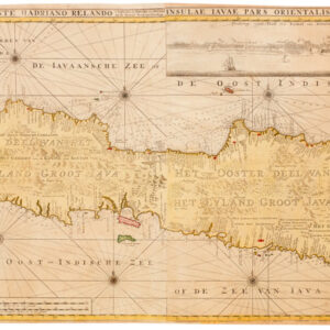
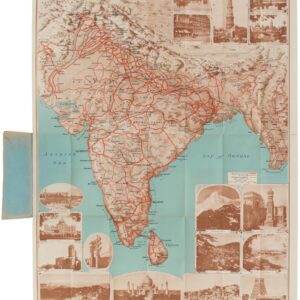
This colorful map shows us a topographic rendition of the East Indies, as understood in the early 20th century. The mapmaker has chosen a traditional Mercator projection, which works well given the region’s proximity to the Equator. The map was compiled and published by H.E.C. Robinson, one of Australia’s most prolific cartographers, whose firm worked out of offices on George Street in Sydney.
The Robinson firm was an esteemed creator of new maps – probably the most significant Australian mapmaking firm in the early 20th century. Their specialty was maps for educational and display purposes, but the Robinson firm also produced town plans, city maps, and more historical maps. Their maps of Sydney, in particular, have today become highly collectible.
The maps of the Robinson firm consistently show place names in English, and this sheet, which is map number 316, was done on a scale of 85 miles to the inch. The coloring is kept in clear, crisp tones, with water held in blue and land predominantly green. Color graduations on land reflect heights above sea level, as shown in the small legend of the main map’s upper right corner. Above this is an inset of Papua & New Guinea on the same scale as the map proper.
In addition to the usual inclusion of cities and international boundaries, this map indicates naval bases (red dots), railroads (black lines), as well as air and shipping routes (the latter in blue and with the specific destinations indicated for each route).
Cartographer(s):
Herbert Edward Cooper Robinson (1857 – 1933) was a prolific Australian publisher and cartographer who in 1885 founded the Royal Geographical Society of Australasia. Ten years later, in 1895, Robinson set up his own mapmaking firm at Wentworth Court in Sydney. Later, in the 1920s, he would also become a member of the Geographical Society of New South Wales and a fellow of the Royal Geographical Society of London.
As a mapmaker, Robinson made many valuable contributions to the field of Geography. Among the foremost examples was a long-standing collaboration with Professor Edgeworth David, whose monumental Geological Map of the Commonwealth of Australia (1932) he and his company helped compile and produce. It was also Robinson’s company and draughtsmen that created the maps for Donald Mackay’s important aerial surveys of Australia in the early 1930s.
Robinson set up his business in 1895, but it was only at the dawn of the 20th century that the firm experienced real growth. By 1906, they had relocated to Phillip Street, and by 1913, Robinson has settled into his final and permanent locale at 221-223 George Street. By 1917, H.E.C. Robinson Ltd was officially incorporated.
In addition to contributing to some of the cartographic milestones in Australia’s history and publishing a plethora of his own material, Robinson was also a delegate to the Sydney Regional Plan Convention in 1923.
Condition Description
Large folding map on nice cloth paper. Title stencil on out-facing section.
Splits at some folds and wear at intersections.
References