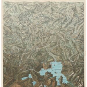
A large, exquisite topographical map of Arizona, produced after World War II by the most reliable mapping agency on the planet.
State of Arizona.
$650
1 in stock
Description
This stunning topographical wall map of the State of Arizona was compiled and published by the United States Geological Survey (USGS). Even though the core data for this map were compiled as early as 1927, the sheet was not published in its current format until 1959. Among the updated data sets incorporated into this edition of the map was the state’s latest demography. Like most of America, the population of Arizona had grown significantly between the late 1920s and the late 1950s. We note that the demographic data used for this map is from 1955.
The map is one of the commercial sheets produced by the USGS after WWII and was done in a standard 1:500,000 scale (implying that one inch equals about 8 miles), with contour intervals at every 500 feet. This resolution ensures an extremely high level of accuracy and detail. The map is one of those charts that is relatively easy to approach because it essentially is a topographic map that has been expanded to include a range of other cartographic, toponymic, and geographic data. It would make an attractive display piece for any collector of maps related to Arizona or the West.
The United States Geological Survey
Since its establishment in 1879, the United States Geological Survey (USGS) has played a crucial role in the scientific exploration and understanding of America’s geological and natural resources. The USGS was founded as a part of the federal government’s commitment to mapping and studying the vast and uncharted western territories. Its primary mission was to survey and map the country’s geological features, minerals, and water resources. In the early years, the agency focused on producing topographic maps, conducting geological surveys, and studying the nation’s mineral resources. But from the dawn of the 20th century, the USGS expanded its efforts to provide detailed topographic maps, among other things, for land development and navigation. Research on water resources and mineral exploration continued to be core activities, and USGS scientists would also mount investigations of Alaska’s natural resources, contributing significantly to its eventual statehood.
The USGS played a pivotal role during World War II by conducting surveys and producing maps crucial for military operations. After the war, the agency shifted its focus to environmental issues, conducting studies on water quality, land use, and natural hazards. Our map of Arizona comes from this era of consolidation and renewal.
Since the 1970s, the USGS has evolved to address contemporary challenges, including environmental conservation, climate change, and natural disaster monitoring. It researches earthquakes, volcanoes, and landslides, providing vital information for disaster preparedness. The agency also monitors land use, ecosystems, and water resource changes, contributing to sustainable resource management. To this day, the USGS’ commitment to the mapping, exploration, and scientific study of American landscapes continues to be instrumental in shaping the nation’s understanding of its geological and natural heritage.
Cartographer(s):
Created by an act of Congress in 1879, the United States Geological Survey (USGS) is a scientific agency under the U.S. government whose purpose is to investigate, survey, and map the United States territory, including natural resources and any potential threats to the depicted habitat. The organization has evolved over time, gradually adapting to the progress of science and technology.
The USGS is the only science-based agency under the Department of the Interior, and its responsibilities fall within the disciplines of biology, geography, geology, and hydrology. The USGS is considered the best authority on domestic questions relating to these subjects, and often their maps will cover several or all of these themes in the same chart.
Condition Description
Very good. Light wear and small creases along edge.
References