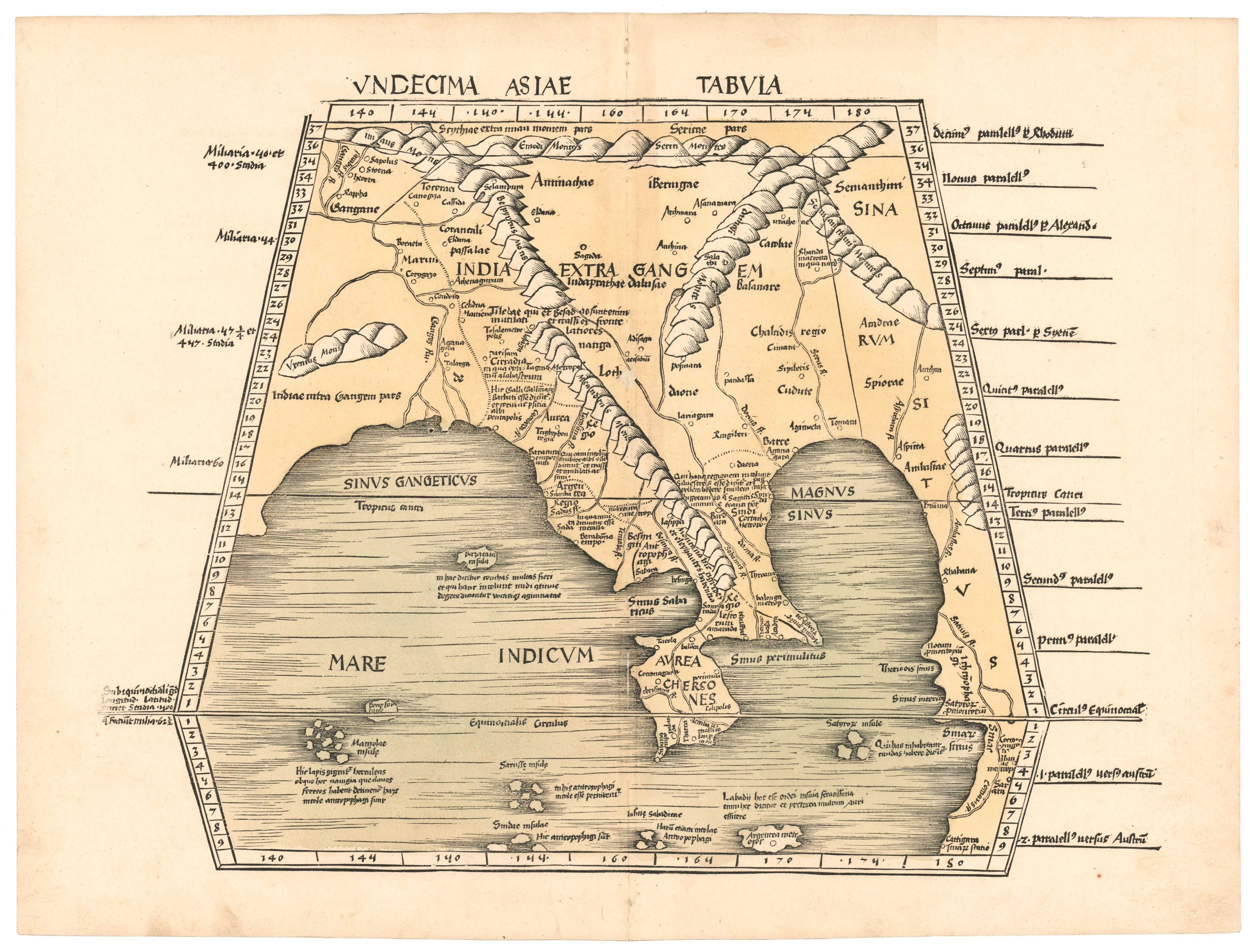
Bünting’s iconic Pegasus Map of Asia: an enduring cartographic masterpiece that continues to captivate us centuries after its creation.
[First Edition] Asia Secunda pars Terrae in Forma Pegasi.
Out of stock
Description
Heinrich Bünting’s remarkable map of Asia, first issued in 1587, is an exquisite masterpiece of 16th-century German cartography. It is often referred to as the “Pegasus Map” because it casts the great continent in the form of a winged horse: its head forming the Anatolian Plateau; its front legs the Arabian Peninsula; its body by greater Persia; and its hind legs and tail delineating the enormous landmasses of India and China. Its wings, raised triumphantly from the animal’s back, constitute the endless plains of Scythia and Tartaria. Beyond the scope of the animal itself, we find schematic renditions of both Europe and Africa, revealing the continental trinity of the Ptolemaic worldview, a model replicated in Bünting’s equally famous Clover Leaf Map.
Bünting’s innovative composition was deeply captivating to its audience. On the one hand, finding within the confines of this mythical beast a delineation of an almost equally legendary continent was confounding. On the other hand, the design was executed in simple and crisp lines, making the map relatively straightforward to understand – even for the untrained eye. While the geographical accuracy of Bünting’s extraordinary creation is highly schematic, his amalgamation of cartography and figurative art is not only spellbinding but an innovative play on the artistic dynamics of the late Renaissance.
The Pegasus and Clover Leaf were not the only figurative maps Bünting compiled in the late 16th century and have since become iconic. An equally strange and memorable map showed Europe in the form of a powerful female monarch.
Context is Everything
Heinrich Bünting was a renowned German theologian and cartographer who crafted this particular map at the height of the 16th century’s obsession with exploration and discovery. Every day, reports from Asia, Africa, and the Americas were reshaping how Europeans understood the world. So audiences grew flexible and curious, open to new ideas – even if they were inaccurate. Despite its blatant manipulation of physical reality, the Pegasus Map became hugely influential in shaping North European perceptions of Asia during the late 16th century. As such, it played a pivotal role in disseminating geographical knowledge – especially north of the Alps.
The Pegasus was a mythical creature dating back to Antiquity, an ideal symbol for late Renaissance cartographers. According to Greek legend, Pegasus was born from the neck of the Gorgon Medusa after Perseus had severed her head. Rising heavenward towards Helicon, the home of the Muses, Pegasus became a symbol of strength, virtue, and creative inspiration.
Heinrich Bünting’s Pegasus Map is a remarkable testament to the intersection of art, history, and cartography in the 16th century. Its symbolic portrayal of Asia as a majestic winged horse captures the imagination and offers a unique perspective on a distant world drawing ever closer. It does not matter whether you are an art enthusiast, history buff, or cartography aficionado; this map is simply transporting.
Census
Neatline’s example of the Pegasus Map comes from Bünting’s most well-known work, the Itinerarium Sacrae Scripturae, published in Magdeburg in 1587. The Itinerarium essentially constituted a pilgrim’s travelogue to the Holy Land, but it provided the perfect platform for Bünting to experiment with his creative cartography. Because the Pegasus Map has become Bünting’s most desirable and collectible cartographic creation, many examples have been removed from their original binding. Finding an intact example of the Itinerarium in the first edition is increasingly rare.
The OCLC lists holdings of the Pegasus Map at Cambridge (no. 419237591), Yale (no. 728290694), The National Library of Singapore (no. 865608907), and the State Library of New South Wales (no. 728290694). Institutional examples of the entire book in the first edition are slightly more common – especially in German libraries. Examples include the Bayerische Staatsbibliothek, Universitätsbibliothek Eichstätt-Ingolstadt, and the Staats- und Stadtbibliothek Augsburg (no. 633515644).
Cartographer(s):
Henrich Bünting was a Protestant theologian and teacher from Hannover who is most renowned for his influential work on Biblical geography. His Itinerarium Sacrae Scripturae, first published in 1581, became very popular due to its comprehensive summary of Biblical geography through travel narratives and commentary. The book contained Bünting’s own unique woodcut maps, including imaginative representations of the continents as a Clover Leaf, Europe personified as a crowned woman, and Asia depicted as the winged horse Pegasus.
With over sixty editions published between 1581 and 1757, Heinrich Bünting’s Itinerarium Sacrae Scripturae remains a significant contribution to the history of Biblical geography.
Condition Description
Excellent. Sharp wood engraving printed on paper. Centerfold is as published. Wide margins.
References
Many thanks to James Roy for his work on dating this map.
![[Political broadside] Solidarity with the People and Students of the DPR of Korea.](https://neatlinemaps.com/wp-content/uploads/2022/10/NL-01603_thumbnail-1-300x300.jpg)
![[Political broadside] Solidarity with the People and Students of the DPR of Korea.](https://neatlinemaps.com/wp-content/uploads/2022/10/NL-01603_thumbnail-scaled.jpg)
![[Political broadside] Solidarity with the People and Students of the DPR of Korea.](https://neatlinemaps.com/wp-content/uploads/2022/10/NL-01603_thumbnail-scaled-300x300.jpg)