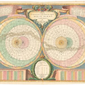
An innovation in French cartography: Sanson’s double polar projection from 1657.
Les deux poles arctique ou septentrional, et Antarctique ou meridional, ou description des terres arctiques et antarctiques, et des pays circomvoisins jusques aux 45 degres de latitude…1657
$1,250
1 in stock
Description
This dual hemisphere polar projection by Nicolas Sanson d’Abbeville, the so-called father of French cartography, constitutes one of the first serious attempts to delineate a new 17th-century understanding of the Earth’s polar regions. As indicated in the title, each hemisphere includes 45 degrees of latitude from its respective pole. Opting for this model deliberately omits the majority of known landmasses, revealing a very concrete and particular objective behind this map.
During the 16th and early 17th centuries, the scope of global trade and exploration exploded. New players had entered the stage, and enormous wealth was up for grabs for those bold enough to pursue it. As cartographer to the King, Sanson had access to the latest information available to French mapmakers, allowing him to produce a compilation as bold as this.
Despite cartographic efforts dating back to the 15th century, most of the Arctic Circle was as unknown as its Antarctic counterpart. In this sense, our map is a window into all that still remained unknown. As we shall come to see, Sanson’s chart is a characteristic product of its age, building as much on myth and imagination as it does on reliable sources.
A Great Southern Continent
The map consists of two hemispheres. On the left is the South Pole, here depicted as an enormous polar continent, which is broadly known as Terra Australis Incognita. This concept of an unexplored continent at the South Pole was popularized in the early Renaissance and continued to be incorporated on maps long after the Age of Exploration. One powerful impetus was Magellan’s circumnavigation of the globe. Passing through what today is known as the Straits of Magellan, the expedition noted a large landmass to their south. Even though they gave it a distinct name, this land was soon interpreted by cartographers back in Europe as part of the legendary Antarctic landmass. Consequently, it is common to see Tierra del Fuego amalgamated in different ways with the southern continent on 16th-century maps of the New World.
Sanson’s Source
By the time Sanson was working in the mid-17th century, this perspective had become significantly more nuanced. Sanson correctly shows Tierra del Fuego as a separate landmass that is not physically connected to the great southern continent (even though he also obscures the relationship by labeling his antarctic continent Terre Magellanicque, Australe, Incogneue).
Sanson’s is one of the first innovative manifestations of this more refined view of the South Pole. The change in perspective was the result of Jacob Le Maire and Willem Schouten’s expedition to Australia in 1615 (hyperlink to the book, for SEO purposes). This privately funded enterprise set out from Holland to build an independent trading company on the newly discovered Australian landmass. Their route followed that of Magellan but provided far more detailed records of the passage into the Pacific. Among their discoveries was proof that Tierra del Fuego was an island and thus not connected to Antarctica. The expedition also found a more southern route, sailing along the east coast of Tierra del Fuego and passing between it and Staten Landt (here, Terre des Estats). To this day, this strait is named after Le Maire.
The notion of a great southern continent was not rejected until James Cook searched for this mythical continent during his second expedition in the 1770s. As part of his efforts, Cook (unknowingly) circumnavigated Antarctica, but at a latitude that prevented him from identifying any actual coastline.
The Arctic Frontier
On the right side of the map is the North Pole. In many ways, this was a more familiar space for European mapmakers, although Arctic knowledge was still scant. Fascination with the Arctic had for centuries been related to the search for a northern route to Asia – the so-called Northwest or Northeast Passage. It was this same motivation that drove Sanson to compile the current map.
During the late 16th and early 17th centuries, men like Martin Frobisher, John Davis, and William Baffin explored the possibility of a Northwest Passage but failed to find a viable route. To the east, Dutch navigator Willem Barentsz led no less than three expeditions into the Arctic Sea, discovering the islands of Novaya Zemlya, Spitsbergen, and Bear Island and navigating the ferocious Kara Sea. These expeditions undoubtedly informed Sanson’s work, and we note how he includes the islands discovered by Barentsz with meticulous precision. However, it is equally clear that where Barentsz was repelled, so all accurate knowledge stops.
According to Sanson’s map, one could reach the northern coasts of China and even the mysterious land of Yezo by sailing around Novaya Zemlya. The eastern coast of this large island is not delineated on Sanson’s map, which in itself shows how dodgy the geography beyond this point was. Yet despite this, Sanson draws the Siberian coastline as dropping into an enormous bay labeled Mer de Tartarie, which at its centre is dominated by a large island named Tazala.
Yezo, Iesso, or America?
Beyond Sanson’s Tartary Sea, the Asian landmass continues, rounding gently to the south to form the coasts of Cathay or China. Interestingly, only a narrow sliver of sea separates this relatively known region of the planet from what one must assume is the Pacific Northwest. This great western continent is connected to the known parts of North America further west, but the connection is clearly strained and speculative. The western two-thirds of this giant continent is labeled “Terre de Yezo, ou Iesso” but contains no other toponymy than that, underscoring that this is terra incognita.
The term Yezo or Iesso are references to the Yedso myth, which originated with the accounts of Marco Polo and normally is associated with Japan, or more specifically the island of Hokkaido. But even though the Yedso toponym is relatively common in late 16th and 17th century maps of this region, the depiction of it as a gigantic American landmass is quite anomalous.
Census
This map is significant in the history of polar mapping as it was one of the first to use a dual hemisphere format with 45 degrees of latitude, allowing for a comprehensive overview of both polar regions. It was compiled and printed in 1657 and subsequently published in Sanson’s atlas Cartes generales de toutes les parties du monde, ou les empires, monarchies, republiques, estats, peuples from 1658. Intact examples of this 17th-century atlas are extremely rare, with copies being held only in key collections such as Oxford University (OCLC no. 928842744), the Bibliothéque Diderot in Lyon, or the Conservatoire national des arts et métiers in Paris (OCLC no. 491622099).
Among the maps from this atlas, the dual hemisphere polar projection is among the most popular and sought after due to its innovative approach and early date. The Bibliothéque national de France (OCLC no. 494257361) is the only institution recorded by the OCLC that has a loose sheet example of this particular map.
Cartographer(s):
Nicolas Sanson d’Abbeville (1600-67) was perhaps the greatest cartographer of 17th century France — a period of France’s political ascendancy in Europe and also a period in which French cartographers displaced the Dutch as Europe’s leading map makers.
As a young man, he attracted the attention of Cardinal Richelieu and, in time, became Géographe Ordinaire du Roi for Louis XIII and Louis XIV, both of whom he personally instructed in geography. Under Louis XIII, Sanson became a minister of state. Sanson has become known as the “father of French cartography,” and his influence is such that the sinusoidal projection he employed has become known as the “Sanson-Flamsteed projection,” recognizing the impact of Sanson (Flamsteed was an English astronomer royal from 1675 to his death in 1719).
Condition Description
Very good. Fold line visible. Uneven toning in margin due to earlier framing. Wear along edge and at corners.
References