The topography and ecology of late Ottoman Palestine.
Map of Western Palestine Illustrating the Natural Drainage and the Mountain Ranges.
Out of stock
Description
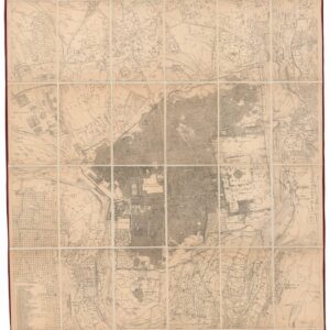
This is the 6-sheet ‘Natural Drainage’ map from the Survey of Western Palestine (SWP), published in 1881. The map is essentially a topographical and hydrographical map combined, rendering the contours of the natural landscape to demonstrate the natural flow of surface water.
Harnessing potable water is fundamental to life in semi-arid zones such as the Middle East, and so understanding the natural presence and flow of water constituted a critical aim of the much larger SWP project. The scope of the map is, as indicated in the title, the full extent of Western Palestine, meaning from the Mediterranean coast to the River Jordan. To the south, the map includes Gaza and Beersheba, and in the north, the Kadimiyeh River in modern Lebanon forms a dividing line between mapped and unmapped regions.
In addition to the detailed topography, the map is flanked by section profiles of specific mountain ranges. On the left, we see the Mountains of Judea, the Hills of Samaria, and the Lower and Upper Galilee highlands. Along the bottom, the coastal plain is shown rising gradually from sea level to the Mountains of Judea, after which it drops into the Judean Desert beyond. And along the top, we again have the summits of Lower and Upper Galilee, only as seen from the south and including Mount Carmel.
PEF and the Survey of Western Palestine
The Victorian Era saw the emergence of an early modern mindset. Part of this entailed a passionate re-envisioning of the past. It was thought that by rediscovering its civilizational roots, Christendom might begin to align the old tenets of faith with the new advances of science. No place on Earth was more the target of such romantic ambitions than the Biblical land of Palestine. Ruled for centuries by the Ottomans, the Victorian travel craze made this region more accessible to Europeans than it had even been before, and it was within this elated context of exploration and adventure that our seminal map was created.
From 1872 to 1881, the Palestine Exploration Fund (PEF) conducted a comprehensive Survey of Palestine for almost a decade. The Royal Engineers carried out most of the work, and the task was divided into distinct parts from the outset. The Western Palestine survey (1872-1877) was led by Captain Richard Warren Stewart, Lieutenant Claude Conder, and Lieutenant Herbert Kitchener and covered a total area of 6,040 square miles. In contrast, the smaller Eastern Palestine survey (1880) was led by Conder alone and covered 510 square miles of sparsely populated land in what today is Jordan (incl. Amman and Madaba). This extensive fieldwork culminated in the first scientific mapping of the region.
The PEF survey went far beyond the scope of geography. Among their many efforts, the team collated thousands of place names to identify sites associated with Biblical, Talmudic, early Christian, or Crusader history. The primary cartographic outcome for the Survey of Western Palestine was an enormous 26-sheet map executed at a scale of 1:63,360 (also known as the ‘one-inch map’). This was the region’s most detailed and accurate map ever produced and still represents a pinnacle of Victorian mapping.
In addition to a series of highly accurate maps, the PEF published extensive fieldwork in three critical volumes known as The Survey of Western Palestine (1881). This report carefully describes the landscape and cross-references the descriptions to historical sources. It was a work of genuine scholarship, and to this day, archaeologists use the Survey as a standard reference for understanding the diachronic development of the landscape and its toponyms.
Political connotations
Even though the foundation and management of the PEF were strongly influenced by the faith of its members and the religious significance of Palestine, the involvement of British Army Royal Engineers in the survey was no coincidence. Britain had entertained strategic interests in the region for some time and had, at least since the Ordnance Survey of Jerusalem in 1864-65, used the Victorian affinity for travel and pilgrimage to gain access to Ottoman Palestine. The War Office played an important role in shaping and executing the survey. Colonel Charles Wilson, who had commanded the initial Ordnance Survey of Jerusalem and was intimately familiar with Britain’s strategic interests in the region, was appointed liaison between the government and PEF’s Executive Committee. The survey was a grand success, and the publication that came from it was sought by governments, institutions, and individuals across the globe. The acclaim also stimulated other interests in Palestine at the time, such as the growth of Zionism.
When the PEF expanded its sphere of interest to cover all Biblical lands, including the Sinai Peninsula, this was at least partly driven by Britain’s strategic interest in the Suez Canal. Another critical factor was the recent Russo-Turkish War (1877-78), making the paucity of accurate mapping in this region clear. Such strategic interests were intertwined with a heartfelt desire among PEF members to explore the past. The two aims were not perceived as contradictory but as a corollary. The PEF Survey of Palestine remained the region’s most influential and reliable map until the British Mandate’s Survey of Palestine, which commenced half a century later.
Cartographer(s):
Horatio Herbert Kitchener, 1st Earl Kitchener, was an Irish-born British Field Marshal and proconsul who gained fame for his imperial campaigns and later played a central role in the early part of the First World War, although he died halfway through it. In 1874, at age 24, the Palestine Exploration Fund tasked Kitchener to carry out a topographical survey of the Holy Land, replacing Charles Tyrwhitt-Drake, who had died of malaria.
Together with fellow Royal Engineer Claude R. Conder, Kitchener surveyed the region between 1874 and 1877, collecting data on the topography and toponymy of the area, as well as on local flora and fauna.
Edward StanfordEdward Stanford (1827-1904) was a prominent British cartographer and entrepreneur who founded Stanford’s, a map-selling business that became one of the most significant map publishing companies in the 19th and 20th centuries. Established in 1853, his London-based shop was renowned for its extensive range of topographic and thematic maps.
Stanford’s attention to detail and dedication to producing accurate, up-to-date maps made his firm the official map supplier to the British government during several notable expeditions. In addition to supplying explorers, the general public, and various institutions with reliable maps, Stanford’s legacy also includes the notable “Stanford’s Library Map of London and its Suburbs,” which was acclaimed for its precision. The brand he founded remains respected in the cartographic world and has also expanded into travel books and accessories.
Trelawny Saunders was a 19th-century British map publisher and geographer. He was known for producing a variety of maps, especially during the mid to late 1800s. Saunders had a particular interest in improving the design and accessibility of maps, believing in their educational value.
One of his notable achievements was advocating for and producing “relief maps” that provided a more intuitive representation of physical geography, especially for educational purposes. These maps aimed to represent the terrain’s physical features in a way that was easier for the general public and students to understand, compared to traditional contour maps.
Saunders was a Fellow of the Royal Geographical Society (FRGS).
Condition Description
Minor wear.
References
![ОБЩІЙ ВИДЪ СВ. ГРАДА ІЕРУСАЛИМА [General View of the Holy City of Jerusalem].](https://neatlinemaps.com/wp-content/uploads/2026/02/NL-02492_thumbnail-300x300.jpg)