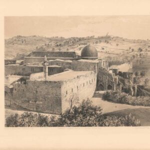
An early Victorian bird’s-eye-view of the Old City of Jerusalem, drawn by Nathaniel Whittock.
Panoramic View of Jerusalem and the Adjacent Towns and Villages – Taken from the Heights of Bethlehem by the Librarian of the Armenian Convent.
$975
In stock
Description
This panoramic map of Jerusalem and the adjacent towns and villages was compiled and engraved by Nathaniel Whittock from a drawing made by the librarian of the Armenian Convent. The view is bound in a booklet that includes a short description of each site on the map. The volume was published in 1845 by David Bogue in London, with the map sectioned into nine panels and mounted on linen. It opens to 38 x 28 cm and, when folded (14 x 10 cm), is held in the original brown cloth boards with an impressed and gilded title.
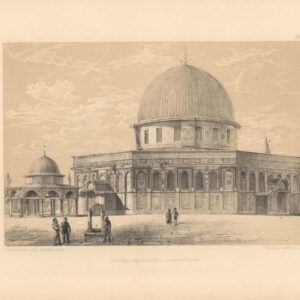
The panoramic map constitutes an oblique bird’s-eye-view of the Holy City as seen from the south. The walled town is set atop an elevated plateau and surrounded by iconic hilltops and valleys, made famous by the Biblical narrative. The city is rendered meticulously, with streets and individual buildings standing out clearly from the whole. Among the landmarks are the essential religious complexes of the Holy Sepulchre and Haram al-Sharif (or Sacred Precinct). The Dome of the Rock, in particular, stands out as the city’s most prominent and highest building.
As indicated in the title, the view is drawn from a vantage point in the heights of Bethlehem, and the town itself can be seen at the bottom of the composition. In both the Old City and the surrounding landscape, key points have been labeled with numbers that refer to the paneled legend below the view. No less than sixty points of interest have been identified here.
Census
Whittock’s panoramic map of Jerusalem is scarce. The British Library has an example not listed with the OCLC (UIN: BLL01008931703), which otherwise lists only two institutional copies of the 1845 edition, held at Harvard and Oxford’s Bodleian Library (no. 925359757). The same two institutions and the library at SOAS in London (EA84.44 /362959) also hold an earlier edition from 1842, published by Tilt & Bogue (OCLC no. 925359680).
Cartographer(s):
Nathaniel Whittock (1791-1860) was a topographical engraver specializing in bird’s eye views. A view of the Old City of Jerusalem, published in 1845, was among his early successes as an engraver and printmaker. Later in life, he also produced several instruction manuals on drawing and painting for the many aspiring Victorian artists.
Condition Description
Good. Dissected and laid on linen. Foxing, especially at the top and in the margins. Creasing and wear around the edge. Folds into original cover, which also includes descriptive booklet. A couple of areas of soiling.
References
Related products
-
-
Add to cart

- Eastern Mediterranean - Holy Land, Wall maps
Map of Western Palestine from surveys conducted for The Committee of the Palestine Exploration Fund. By Lieuts. C. R. Conder and H. H. Kitchener, R. E. Reduced from the one inch map in twenty six sheets. Special Edition Illustrating The New Testament also The Talmud and Josephus (after the birth of Jesus)…
- $1,000
-
-
-
![Jerusalem [Old City].](https://neatlinemaps.com/wp-content/uploads/2024/05/NL-01944_thumbnail-300x300.jpg)