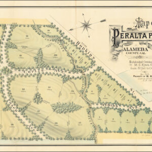
Early pre-Mill Valley cadastral map of Eastland and Millwood, Marin County.
Tamalpais Land and Water Company Map No. 5 showing Eastland and Millwood, Marin County, California.
$2,800
In stock
Description
This late 19th-century cadastral map shows the neighborhoods of Eastland and Millwood in Marin County before they were consolidated into the town of Mill Valley.
Mill Valley is located on the eastern slopes of Mount Tamalpais and the western and northern shores of Richardson Bay. Before the completion of the Golden Gate Bridge, the town was a sleepy lumber center and tourist destination. In 1900, three years after this map was created, the population of Mill Valley counted only 900 residents. The largest and most important stakeholder in land and infrastructure in Mill Valley at the time was the Tamalpais Land & Water Company.
Among the historical features worth noting on this map are two railroads culminating at the central railway hub, Eastland Station, on Miller Avenue. Running roughly south out of town, we find the final leg of the North Pacific Coast Railroad, which Eastland had lobbied hard to ensure would connect this budding settlement to the rest of the Bay Area. After this had been achieved in 1889, Mill Valley saw its first significant influx of new settlers. The second came after the 1906 earthquake and its devastation in San Francisco. The map’s southern route includes a second stop at Millwood Station, near the junction of Miller Avenue and Willow Street.
Running more or less north out of Eastland Station but quickly winding its way up and around the summit of Mount Tamalpais, we find the historic Muir Woods and Tamalpais Scenic Railroad. This serpentine route opened the same year that this map was created (1897), covering only the 8.19 miles (13.18 km) between Eastland Station and the eastern peak of Mt Tamalpais (from where an additional spur line ran just under 3 miles to Muir Woods). It was widely known as the Crookedest Railroad in the World. It was renowned for its picturesque terrain, first-class hospitality, and panoramic views of San Francisco and the Bay Area.
Context is Everything
During the formative years that followed the Gold Rush, some who were unsuccessful at mining gold decided to venture north to the Marin Headlands, where many tried their hands at farming. In Mill Valley, Ranch B is one of the few remaining dairy farm buildings from this era (near the Tennessee Valley trailhead). Among those who first settled here was Samuel Reading Throckmorton, who had come to San Francisco in 1850 as an agent for an eastern mining business but soon began working for local rancher and landowner William A. Richardson.
In 1853–54, Throckmorton acquired a substantial portion of the Rancho Saucelito and built his ranch, The Homestead, on what is now Linden Lane and Montford Avenue. Despite severe financial problems, Throckmorton became a founding figure of Mill Valley, and by the time of our map, his name defined one of the budding city’s major thoroughfares, much as it does today.
In 1889, the San Francisco Savings & Union Bank forced Throckmorton’s daughter, Suzanna, to relinquish several thousand acres to satisfy a debt of $100,000 against the estate. Shortly after acquiring the land, the bank created the Tamalpais Land & Water Company as an agency for disposing of the land gained from the Throckmorton debt. The Board of Directors was President Joseph Eastland, Secretary Louis L. Janes (Janes Street), Thomas Magee (Magee Avenue), Albert Miller (Miller Avenue), and Lovell White (Lovell Avenue).
Joseph Eastland was an early entrepreneur who founded a number of companies all around the Bay Area. He was also on the board of several San Francisco banks and was briefly president of the North Pacific Coast Railroad in 1877. Retaining a personal stake in the railroad company, Eastland was the one who made sure that the railroad in 1889 was extended into the settlement. Though many were crucial to bringing people to the Mill Valley area, Eastland’s connections to San Francisco and the rest of the Bay Area promoted the area and laid the foundation for creating the town.
While Eastland and others were using their connections and wealth to develop the area, the Tamalpais Land & Water Company hired noted engineer Michael M. O’Shaughnessy to lay out roads, pedestrian paths, and step systems, many of which are evident from this map. O’Shaughnessy also built the Cascade Dam & Reservoir for water supply and set aside land plots for churches, schools, and parks, many of which were still labeled ‘reserved’ when this map was compiled (especially around Cascade Drive and the Old Mill).
O’Shaughnessy produced a version of this map in 1891 (link). Neatline’s example is a revised state produced by city surveyor A.D. Avery six years later.
Cartographer(s):
A.D. Avery was an American civil engineer and surveyor based in the Bay Area of California.
Condition Description
Minor repairs, including upper right corner.
References