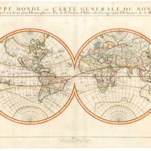
“…arguably the finest depiction of the Americas published in the seventeenth century.” (Burden, p. 248)
Americæ sive Indiæ Occidentalis Tabula Generalis.
$1,200
1 in stock
Description
Johannes De Laet’s seminal map of the Americas is a milestone in early 17th-century cartography. It was featured in the book Nieuwe Wereldt ofte Beschrijvinghe van West-Indien (a.k.a. History of the New World), for which De Laet carefully collected and combed through every source he could find on the Western Hemisphere’s geography.
Access to fresh data was not an issue for De Laet. He was one of the founding members of the Dutch West India Company and served as its first director from the company’s creation in 1621 until he died in 1649. In this role, De Laet spearheaded Dutch interests in the Americas (and to some extent in Africa), and he thus had access to the latest reports and surveys from the New World.
The maps compiled for Beschrijvinghe van West-Indien have stood the test of time and are sought-after collector’s items today. De Laet’s access and meticulous compilation meant that his work constituted some of the most accurate maps of America at the time. This is seen most clearly in the general overview map of the Western Hemisphere. Unlike almost all other Dutch maps of North America in this period, De Laet refuses to depict California as an island. Finding too little corroborating evidence besides colleagues’ insistence, he decided to rely more on Spanish sources such as Herrera, who insisted on California’s peninsular form. Phillip Burden drives this point home in his excellent catalog of early maps of America by calling Laet’s map “…the best West Coast delineation to date”.
In addition to the much-improved configuration of landmasses, De Laet’s maps were also the first printed maps to use the toponyms Manhattan, New Amsterdam (now New York), and Massachusetts.
De Laet’s primary partner in compiling his seminal maps was Hessel Gerritsz, chief cartographer of the Dutch East India Company and the apprentice of Willem Blaeu. Together, they created intelligent maps that drew on verified observations and avoided irrelevant controversies. This kind of strategic decision-making is reflected in the deliberate omission of the Arctic Circle in this map. Avoiding the northernmost latitudes meant that De Laet was not drawn into endless discussions about the presence of a Northwest Passage.
In addition to a peninsular California, De Laet’s maps are some of the earliest Dutch maps to introduce a new and crisper style in cartography. Gone were the heavily romanticized compositions of Ortelius and Mercator, and a new and more open engraving style was introduced. While De Laet was one of the earliest proponents of this approach, it was soon adopted by other great Dutch mapmakers such as Jan Janssonius.
Census
The Beschrijvinghe van West-Indien was initially published in 1625, but the first edition focused on Holland’s interests in South America. By the time of the second edition in 1630, the Dutch had a keen interest in their holdings on the East Coast. During the 1620s, a colonial outpost had been established at the southern tip of the island of Manhattan, and in 1625, this fortified settlement, known as New Amsterdam, was formally declared the capital of New Netherlands.
The growing Dutch interest in North America and the fur trade meant a new book edition was necessary. Before publishing, De Laet added a hundred new pages of text about North America and four new maps. The most important of these new engravings was the general map of the two continents, although the latest edition also included an essential foundational map of Canada. Subsequent editions of this expanded version appeared in Latin in 1633 and French in 1640. The same plate was used in all three editions, and no text appears on the verso.
The OCLC lists only two institutional copies of this formative map as an individual sheet (556332940). Examples of the entire second and expanded edition of the Beschrijvinghe van West-Indien from 1630 can be found in various American and European university libraries (no. 899060787).
Cartographer(s):
Johannes de Laet (1581-1649) was a Flemish-Dutch mapmaker. He was born in Antwerp but raised in Amsterdam as a Protestant fleeing Spanish-Catholic persecution. In 1620, he became one of the founders of the Dutch West India Company and served as its first director from its creation until his death in 1649.
As a mapmaker, De Laet worked closely with Hessel Gerritz, the chief cartographer for the Dutch East India Company. He was a respected publisher and intellectual, and in 1618, the city of Leiden sent him as an elder delegate to the Synod of Dort.
Condition Description
Good. Even mat burn around edges and some visible repair tape. Minor nips in the margins. Map image clean and bright.
References
![[With Independent Texas] Mappemonde en deux hémisphères.](https://neatlinemaps.com/wp-content/uploads/2024/05/NL-02089_thumbnail-300x300.jpg)