A definitive overview of world geography at the dawn of the Victorian Age.
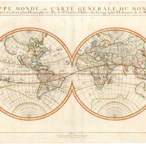
[With Independent Texas] Mappemonde en deux hémisphères.
$600
1 in stock
Description
French Royal hydrographer Adrien Brué compiled this lovely double-hemisphere world map and published it in 1840. The map is a magnificent capture of the state of Europe’s geographic knowledge as the middle of the 19th century approached. Over the coming decades, the Victorian Age would see exploration of even the remotest corners of the world. This massive expansion of geographic and anthropological knowledge was only starting to manifest when Brué updated his plates with the latest information and thus created this important map.
Among the details worth highlighting is Texas. Those historically inclined will be aware that this map was published at the height of the independent Texan Republic (1836-46). But even for the layman, it is clear that there is a high density of place names in this particular part of America. Looking more carefully, we note not only that Brué has included the two new capitals of Houston (1837) and Austin (1839) but also that he fully defines and labels both the Red River and the Rio Grande (here Rio del Norte). This distinguished the new republic from its neighbors and revealed Brué’s sympathy with the Texan cause. This sentiment explicitly echoes the more detailed maps of North America and the United States from the same atlas.
Other exciting and era-specific aspects include a fully delineated Pacific archipelago. Like the Texas situation, this new cartographic frontier was also elaborated in a dedicated map of Oceania. Brué had sailed on these distant lands as a young man, serving as a cabin boy on the Baudin expedition to the South Seas (1800-1804). He nevertheless uses the by-then anachronistic term Nouvelle Hollande (New Holland) alongside the “correct” name of Australia (formalized in 1817), but this was most likely just the French hydrographer teasing the English colonial administration.
Last but not least, Brué’s double hemisphere map provides us with one of the first synergetic depictions of Antarctica. While legends and myths of a great south polar landmass have prevailed since the Age of Exploration, the first firm sightings of the seventh continent had only come in 1820 (Bransfield & von Bellingshausen). Brué was, in other words, trying to combine the first two decades of sporadic information into a single depiction.
Context is Everything
Adrien-Hubert Brué was a Royal Geographer during the July Monarchy (1830-1848), in which Louis Philippe I reigned as King of France—this period of relative calm followed the massive social upheavals of the French Revolution and the subsequent Napoleonic Wars.
As a geographer to the King, Brué produced several vital maps and charts. Still, his most successful endeavor was the Atlas universel de géographie physique, politique, ancienne et moderne, from which this map derives. The original edition of the expanded atlas was issued in 1830, but a decade later, a second and enlarged edition was published. This edition saw several significant changes made to many of the maps inside – especially concerning the political configuration of North America. It is from this enlarged second edition of the atlas that our double hemisphere comes.
Census
The map was published in the second and enlarged edition of Brué’s Atlas universel de géographie physique, politique, ancienne et moderne, published in Paris in 1840. This edition of the atlas included 68 engraved maps, of which 67 were double-page sheets. His maps were drawn directly onto the copper printing plates, and most of the sheets were subsequently hand-colored in outline. The atlas covered contemporary and historical geography, including maps of Alexander the Great’s Empire or the Route of Exodus. It was published multiple times and in different versions between 1820 and 1875, with the first enlarged version issued in 1840. It is from this enlarged edition that our map derives.
The OCLC lists a number of both earlier (1820, 1830, 1835) and later (1842, 1875) states of this map but does not include any examples from the enlarged 1840 atlas from which Neatline’s example derives.
Cartographer(s):
Adrien Hubert Brué (1786-1832) was a French cartographer active in the 18th and 19th centuries. He was born in Paris on March 20, 1786, and died of cholera on July 16, 1832, in Sceaux.
In his youth, Brué served as a cabin boy on various ships, including aboard the Naturaliste, which was part of the Baudin expedition (1800-1804) to the South Seas and New Holland (Australia). Upon his return, he began producing maps for a grand atlas, published for the first time in 1820. A new and better atlas was issued in 1830, the same year he was appointed Royal Geographer.
Brué’s production included various atlases and unique maps, all of which were recognized for the purity of the engraving and the accuracy of the information. His main work, the Atlas universel was expanded multiple by him and Charles Picquet (whose stamp is found on most of Brué’s maps). Among the many aspects that elevated Brué above his peers was the. The fact that he drew his maps directly onto copper plates, a process which he named cartel end prototypes.
Charles PicquetCharles Picquet (1771-1821) was a French cartographer especially celebrated for his collaborations with Adrien-Hubert Brué.
Condition Description
Very good.
References