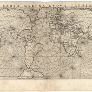
A seminal first! Nicholas Sanson’s double-hemisphere world map from 1651.
Mappe-Monde, ou Carte Generale Du Monde; Dessignee en deux plan-Hemispheres par le Sr. Sanson d’Abbeville, Geographe Ordinaire de la Majeste…1651.
$1,400
1 in stock
Description
This is Nicolas Sanson’s first map of the world and a milestone in French cartography. It was initially issued as a separate sheet under the Mariette name and was soon added to various collections of maps created by the iconic Parisian map publisher. From 1658 until 1676, it was featured in most atlases by Sanson and his sons.
The map has a clean and tight aesthetic, consisting of two detailed and graticuled hemispheres in an otherwise blank space. The map’s title and imprint are above and below the thin border line framing it. The imprint identifies Pierre Mariette as the publisher and Riviere as the engraver.
The map offers a wonderful insight into the state of geographical knowledge in the mid-17th century, with North America being exciting. Early French advancements reports allowed Sanson to offer one of the first delineations of all five Great Lakes on a world map. While he would also be the first to name all five lakes on his 1656 map of New France, only two are named on this earlier map: Lake Superior and Lac des Puans (Lake of evil smells). Most of the information Sanson built this configuration on came from the reports of French Jesuits. Lake Eerie is clearly shown but not labeled, even though Boisseau had included it on his regional map in 1643.
Other innovations Sanson adapts on this map for the first time include depicting California as an island and the detachment of the Pacific Northwest (including Anian, Quivira, and New Albion) from the rest of the North American landmass. While Sanson would keep California insular in his later output, he quickly abandoned the idea of a detached Northwest.
Moving beyond the scope of North America, noteworthy features include a wavering and tentative outline of the great Antarctic continent – Terra Magellanica – which most cartographers still believed existed. This was, however, an age of exploration, and new reports were constantly coming in from voyages all over the globe.
In our map, this is especially noticeable in the delineation of Australia, which in the north is simply labeled Beach. Interestingly, the western and southern coasts appear well-conceived and include toponymic and topographic details. This information was based on the reports of Dutch explorations (even though Van Diemen’s Land was omitted). On the other hand, the northern coast is entirely speculative and would not be fully delineated until Captain Cook sailed on these coasts almost a century later.
Cartographer(s):
Nicolas Sanson d’Abbeville (1600-67) was perhaps the greatest cartographer of 17th century France — a period of France’s political ascendancy in Europe and also a period in which French cartographers displaced the Dutch as Europe’s leading map makers.
As a young man, he attracted the attention of Cardinal Richelieu and, in time, became Géographe Ordinaire du Roi for Louis XIII and Louis XIV, both of whom he personally instructed in geography. Under Louis XIII, Sanson became a minister of state. Sanson has become known as the “father of French cartography,” and his influence is such that the sinusoidal projection he employed has become known as the “Sanson-Flamsteed projection,” recognizing the impact of Sanson (Flamsteed was an English astronomer royal from 1675 to his death in 1719).
Condition Description
Very good. Verso repairs to areas of loss in margins. Minor spots and blemishes here and there, but overall a bright and attractive example.
References
Shirley, 390.

![[World] Continentem Dudum Notam Componebat & Continentem Noviter Detectam Componebat.](https://neatlinemaps.com/wp-content/uploads/2024/04/NL-01969-composite_thumbnail-300x300.jpg)