The Earth’s greatest archipelago in vivid detail.
Carte Générale de l’Oceanie ou Cinquième Partie du Monde.
Out of stock
Description
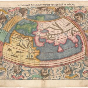
In 1827, Adrien-Hubert Brué unveiled a new map of Oceania, which replaced an earlier version from 1820. The new map was meticulously crafted, covering all of Oceania, including Australia, the Asian Archipelago islands, and the expansive Pacific Ocean. As part of the comprehensive revision, Brué incorporated recent discoveries by European commercial ships, rectifying past errors and showcasing newly charted islands and shoals. Among the features added were more than seventy previously unknown rock islands. Despite earning accolades from his peers for the extensive revisions of 1827, Brué soon saw a need for further updates, which he introduced in 1834. With these final revisions in place, Brué seems to have been satisfied, as evidenced by the fact that the 1834 state was reprinted in multiple editions of his Atlas universel, including the enlarged 1840 edition from which our sheet derives.
One of the places Brué’s commitment to precision is evident is in the extensive annotations, which addressed any uncertainties that persisted. Part of the meticulousness surrounding the Oceania map may stem from the fact that Brué, as a young man, had sailed on this distant land himself, serving as a cabin boy on the Baudin expedition to the South Seas (1800-1804). Yet despite his dedication to accuracy, Brué continued to apply certain anachronistic terms, such as Nouvelle Hollande (New Holland) for Australia itself. The old name was formally replaced in 1817 when New South Wales Governor Lachlan Macquarie endorsed the name Australia in a dispatch to the Colonial Office in London. Over the following years, the New Holland toponym quickly disappeared from common use, but Brué continued to apply it in a blatant snuffing of the English colonial administration.
The chart depicts Oceania in its full scope, which means that large parts of the Pacific were also included on the map. In fact, the scope is so comprehensive that the Baja and California coastline are visible in the upper right corner. This little strip of North America shows the entire Sea of Cortez and towns like San Diego and Santa Barbara. Of particular note is the early inclusion of San Francisco outside the map’s neatline.
Brué merged cartographic expertise and scientific rigor with aesthetics and elegance, creating some of the most visually refined maps of his age.
Census
Adrien-Hubert Brué was a Royal Geographer during the July Monarchy (1830-1848), during which Louis Philippe I reigned as King of France—this period of relative calm followed the massive social upheavals of the French Revolution and the subsequent Napoleonic Wars. As geographer to the King, Brué produced a number of important maps and charts. Still, his most successful endeavor was the Atlas universel de géographie physique, politique, ancienne et moderne, from which this map derives. The original edition of the atlas was issued in 1820, but this was gradually revised and republished until a monumental edition hit the street in 1840. Neatline’s example of the Oceania map comes from this enlarged 1840 edition, even though the map remained in the revised 1834 state discussed above.
The amended map from 1834 can be found in the State Library of Victoria and the National Library of Australia (OCLC no. 221010861). An example of the original map from 1827 can be found among the holdings of the Landesbibliothek Sachsen-Anhalt (OCLC no. 1164147111). The OCLC also identifies examples of this map from an 1875 edition of Brué’s atlas in the Biblioteca Nacional de España, the National Library of Australia, and the State Library of Tasmania (no. 1381474725/1381459604).
Cartographer(s):
Adrien Hubert Brué (1786-1832) was a French cartographer active in the 18th and 19th centuries. He was born in Paris on March 20, 1786, and died of cholera on July 16, 1832, in Sceaux.
In his youth, Brué served as a cabin boy on various ships, including aboard the Naturaliste, which was part of the Baudin expedition (1800-1804) to the South Seas and New Holland (Australia). Upon his return, he began producing maps for a grand atlas, published for the first time in 1820. A new and better atlas was issued in 1830, the same year he was appointed Royal Geographer.
Brué’s production included various atlases and unique maps, all of which were recognized for the purity of the engraving and the accuracy of the information. His main work, the Atlas universel was expanded multiple by him and Charles Picquet (whose stamp is found on most of Brué’s maps). Among the many aspects that elevated Brué above his peers was the. The fact that he drew his maps directly onto copper plates, a process which he named cartel end prototypes.
Chez Charles PiquetChez Charles Piquet was a notable map publishing house in Paris during the 19th century. Charles Piquet, the founder, was a prominent French geographer and cartographer. The publishing house gained distinction for producing high-quality and detailed maps, often focusing on the city of Paris and its surroundings. These maps were known for their accuracy, detail, and artistic merit.
During the 19th century, the field of cartography was evolving with the advancement of surveying techniques and the increasing demand for precise and reliable maps for navigation, urban planning, and military purposes. Piquet’s maps played a significant role in meeting these needs, offering a valuable resource for understanding the geography and urban development of Paris during that era.
Piquet’s work was particularly important in the context of the transformation of Paris under Baron Haussmann in the mid-to-late 19th century, which saw extensive urban renewal and restructuring. Maps produced by Chez Charles Piquet would have provided contemporary and subsequent viewers with an intricate understanding of the city’s layout, streets, and neighborhoods, both before and after Haussmann’s renovations.
Condition Description
Excellent.
References