A superb pair of Baroque maps of Piedmont and the Western Alps.
Il Ducato d’Ausfa, il Canavese, et il Marchesato di Susa… / La Signoria di Vercelli, e la Parte Settentrionale del Monferrato…
$675
1 in stock
Description
This striking pair of engraved maps by Giacomo Cantelli da Vignola, among the foremost Italian cartographers of the late 17th century, depicts northwestern Piedmont and the western Alps, including the Duchy of Aosta, the Marquisate of Susa, the Canavese, Vercelli, Biella, and the northern Monferrato. Both plates were published by Giovanni Giacomo Rossi in Rome for Cantelli’s monumental Mercurio Geografico (1678–1696), one of the defining achievements of Baroque Italian cartography.
The left sheet, Il Ducato d’Ausfa…, extends from the Mont Blanc range and the Valle d’Aosta eastward to Susa, capturing the formidable Alpine barrier that defined the frontier between Savoy and France. The right sheet, La Signoria di Vercelli…, continues eastward to Lago Maggiore, encompassing the fertile plain of the Po River and the Monferrato hills. Together they form a continuous panorama of the northwestern Italian borderlands, rendered with dramatic hachured mountains and detailed topography — a hallmark of Cantelli’s work and a visual triumph of early modern engraving.
The maps reflect both strategic and dynastic geography, portraying territories under the rule or contest of the Houses of Savoy, Mantua, and Milan, regions that would later become pivotal in the wars for control of northern Italy. Each map bears an elegant cartouche framed by allegorical figures and titles declaring Cantelli’s position as Geografo del Serenissimo Duca di Modena, a sign of his courtly prestige.
Cantelli’s engravings combined scientific precision with theatrical composition, bridging the Renaissance and Enlightenment approaches to mapmaking. His maps were among the most influential of their era, directly inspiring the later atlases of Vincenzo Coronelli and Matteo Greuter, and establishing a distinctly Italian aesthetic in European cartography.
Cartographer(s):
Giacomo Cantelli da Vignola (1643–1695) was a prominent Italian cartographer known for his detailed and decorative maps, which significantly contributed to the field of cartography in the 17th century. Born in Vignola, near Modena, Italy, little is known about his early life and education. Cantelli began his cartographic career in the late 17th century, a period marked by increasing sophistication and artistry in mapmaking. He was renowned for his maps’ accuracy and intricate details, often embellished with elaborate cartouches and mythical figures, making them both practical and aesthetically pleasing.
Cantelli produced numerous maps covering various regions of Europe, Asia, and Africa, many of which were included in atlases published by prominent publishers such as Giovanni Giacomo De Rossi in Rome. His maps of Italy, the Balkans, and the Mediterranean region were particularly well-regarded for their precision and detail. Cantelli’s collaboration with De Rossi helped disseminate his work widely, establishing his reputation as a leading cartographer of his time.
Cantelli’s influence on cartography extended beyond his lifetime, setting a standard for mapmaking in the late 17th and early 18th centuries. His combination of artistic elements with geographical accuracy was admired and emulated by other cartographers. Today, Cantelli’s maps are valuable historical documents preserved in libraries, museums, and private collections worldwide, providing insights into the geographical knowledge and artistic sensibilities of the 17th century. Giacomo Cantelli da Vignola remains a significant figure in the history of cartography, remembered for his meticulous and beautifully crafted maps that advanced geographical knowledge during his era.
Condition Description
Good. Periodic staining, light soiling in the margins.
References
Related products
-
-
Add to cart


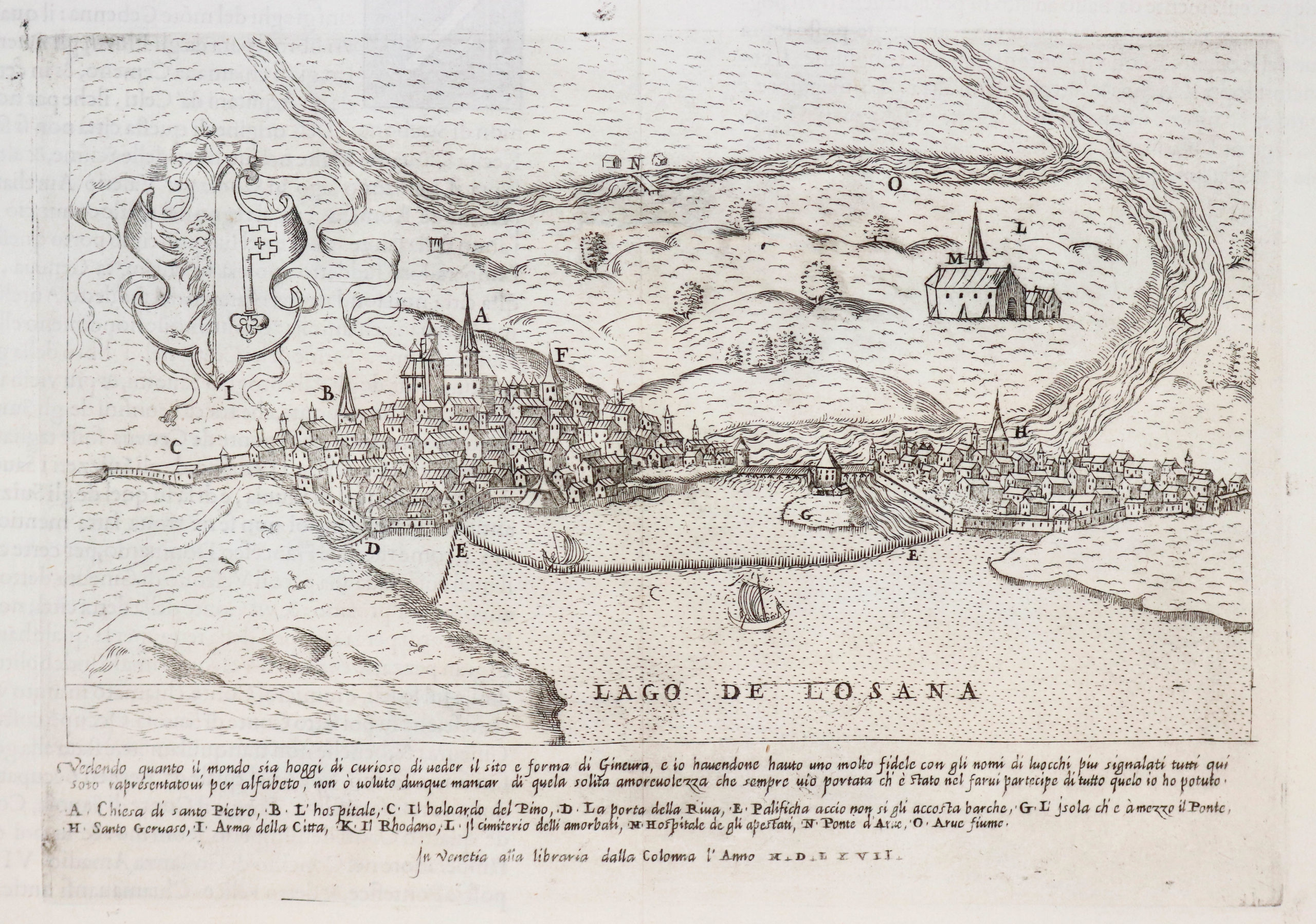
- Europe, Italy, Bird's-eye-views
Venetia.
- $3,500
-
-
-
![[Map of Steamship Routes and the Railways and Post Roads of the Russian Empire]](https://neatlinemaps.com/wp-content/uploads/2020/04/NL-00827_Thumbnail-300x300.jpg)
![[Map of Steamship Routes and the Railways and Post Roads of the Russian Empire]](https://neatlinemaps.com/wp-content/uploads/2020/04/NL-00827-scaled.jpg)
![[Map of Steamship Routes and the Railways and Post Roads of the Russian Empire]](https://neatlinemaps.com/wp-content/uploads/2020/04/NL-00827-scaled-300x300.jpg)