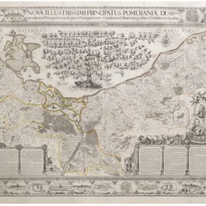
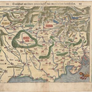
One of the earliest printed maps of southern Germany.
Schwaben und Baierland dar bey auch begriffen erzen Schwartzwald Otenwald und Nordgoew.
Out of stock
Description
An exquisite 1567 double-page map of southern Germany prepared by Sebastian Munster for his Cosmographia.
Oriented towards the south, the view covers much of what is now southern Germany, this historical region of Swabia, including much of Bavaria. Nürnberg appears near the bottom, while Ulm, Ehingen, and other Danube River towns are noted near the center. Worms, Mannheim, Speyer, and other towns along the Rhine River appear at right. Munich appears near the center towards the top-left. Basel, Konstanz, and Switzerland beyond are indicated at the top-right. Roads, rivers, lakes, towns and cities, mountains, and forests are illustrated throughout.
This map appeared in the 1567 German edition of Munster’s Cosmographia.
Cartographer(s):
Sebastian Münster (1488-1552) was a cosmographer and professor of Hebrew who taught at Tübingen, Heidelberg, and Basel. He settled in Basel in 1529 and died there, of the plague, in 1552. Münster was a networking specialist and stood at the center of a large network of scholars from whom he obtained geographic descriptions, maps, and directions.
As a young man, Münster joined the Franciscan order, in which he became a priest. He studied geography at Tübingen, graduating in 1518. Shortly thereafter, he moved to Basel for the first time, where he published a Hebrew grammar, one of the first books in Hebrew published in Germany. In 1521, Münster moved to Heidelberg, where he continued to publish Hebrew texts and the first German books in Aramaic. After converting to Protestantism in 1529, he took over the chair of Hebrew at Basel, where he published his main Hebrew work, a two-volume Old Testament with a Latin translation.
Münster published his first known map, a map of Germany, in 1525. Three years later, he released a treatise on sundials. But it would not be until 1540 that he published his first cartographic tour de force: the Geographia universalis vetus et nova, an updated edition of Ptolemy’s Geography. In addition to the Ptolemaic maps, Münster added 21 modern maps. Among Münster’s innovations was the inclusion of map for each continent, a concept that would influence Abraham Ortelius and other early atlas makers in the decades to come. The Geographia was reprinted in 1542, 1545, and 1552.
Münster’s masterpiece was nevertheless his Cosmographia universalis. First published in 1544, the book was reissued in at least 35 editions by 1628. It was the first German-language description of the world and contained 471 woodcuts and 26 maps over six volumes. The Cosmographia was widely used in the sixteenth and seventeenth centuries and many of its maps were adopted and modified over time, making Münster an influential cornerstone of geographical thought for generations.
Condition Description
Discoloration, wear, and some infill along centerfold. Light soiling in the margins.
References