An early promotional map of Emeryville.
Emeryville Industrial Tract.
$400
1 in stock
Description
This is an early promotional pamphlet for the Emeryville Industrial Tract, a stretch of the East Bay between Oakland and Berkeley that, from the late 19th century, was dedicated to developing heavy industry. The brochure is designed to give potential buyers an overview of the area and an appetite to purchase. San Francisco-based real estate development firm Baldwin & Howell produced it. In the early 1900s, they recognized the strategic potential of Emeryville’s location near rail lines, ports, and urban centers, and the firm played a key role in developing the Industrial Tract. Their efforts attracted diverse industries to the area, including steel manufacturing, chemical production, and food processing, laying the groundwork for Emeryville’s transformation into a bustling industrial hub.
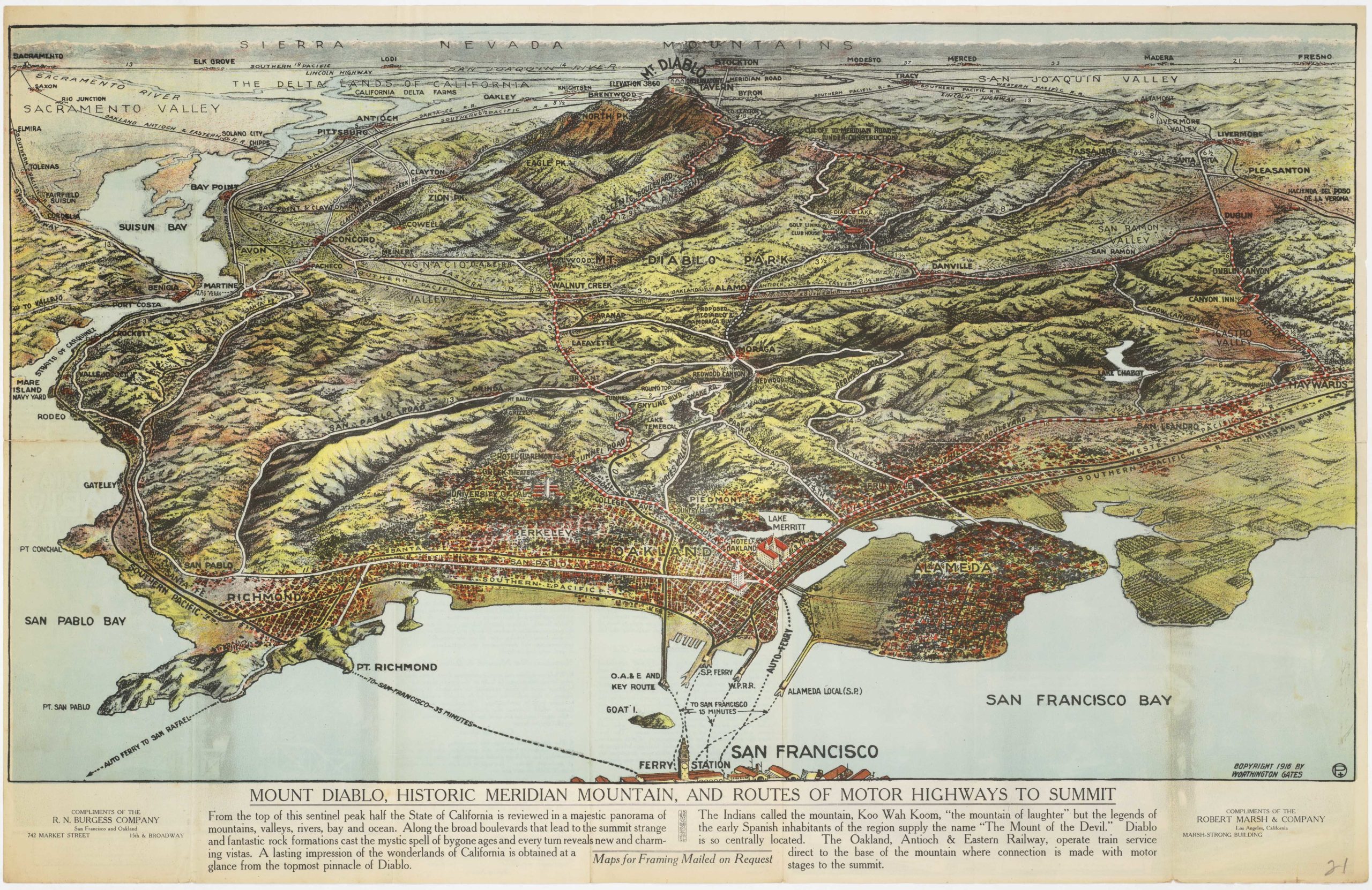
The pamphlet consists of three maps and some text. We find two map-like views of the Emeryville Industrial Tract on the recto. While one is a plan map, providing a detailed view of individual streets and the tract concerning the waterfront and transportation infrastructure, the other is more of an aerial view, positioning the tract within the larger context of the Bay Area and visualizing its relationship to East Bay population centers like Oakland and Berkeley. While the plan map is printed in simple black and white, the view has many prominent features enhanced in bold red.
We are provided with a printed text surrounding a third, more regional map on the verso. The text describes the new town and explains some of the conditions for purchase and development. The aspects covered are location, transportation infrastructure, local government and taxation rates, climate, freight rates, and a list of already established industrial operators in the region. This includes well-known and historical companies such as Standard Oil, Judson Iron Works, the American Rubber Company, and the Western Electric Company. The map in the center of it all depicts the northern half of the Bay and stresses the Industrial Tract’s connectivity to the harbors of Oakland, Richmond, and San Francisco. Thick red letters at the bottom indicate the availability of 4,500,00 square feet at prices starting from 12-15 cents per square foot.
Census
The pamphlet is undated, but given the presence of specific companies and the indicated tax rates for Emeryville, we are comfortable setting a publication date between 1910 and 1920.
The pamphlet is rare. We have found no parallels in institutional collections in California or elsewhere. Similarly, we locate no examples on the market or indeed as historical sales.
The San Francisco Public Library Historical Center holds the entire collection of Baldwin & Howell’s business records. An example likely exists in this collection but has not been identified individually.
Context is Everything
The Emeryville Industrial Tract emerged in the late 19th and early 20th centuries as a significant industrial hub in the Bay Area. Strategically located between Oakland and Berkeley, with access to key rail lines and the waterfront, the area quickly attracted manufacturing and heavy industry. Early developments included steel fabrication, chemical production, paint manufacturing, and food processing.
Following Emeryville’s incorporation as a self-governing city in 1896, the local city council actively began promoting business-friendly policies, which stimulated a massive expansion of the industrial complex. By the early 20th century, the Industrial Tract had become a dense network of factories, warehouses, and rail spurs, supporting everything from meatpacking and canneries to pharmaceuticals and the production of explosives. The presence of the Western Pacific Railroad and Southern Pacific lines made it a critical distribution point for goods across the West.
Despite its economic success, the district was notorious for pollution, labor disputes, and lax zoning regulations that allowed heavy industries to operate near residential areas. For much of the 20th century, the Emeryville Industrial Tract remained one of the most concentrated manufacturing zones in the East Bay, laying the foundation for its later transformation into a center for biotechnology, technology firms, and retail development.
Cartographer(s):
Baldwin & Howell was a prominent San Francisco-based real estate firm active in the Bay Area during the late 19th and early 20th centuries. Founded by real estate visionaries Edgar A. Howell and Joseph M. Baldwin, the firm specialized in large-scale land acquisitions and transforming raw land into industrial and residential districts. Known for their keen eye for strategic locations, Baldwin & Howell played a significant role in shaping the landscape of East Bay cities, not least Emeryville.
In the early 1900s, Baldwin & Howell recognized the potential of Emeryville’s prime location between Oakland and Berkeley, with access to major railroads and the Bay shoreline. The firm facilitated the sale and development of large tracts of land in what became the Emeryville Industrial Tract, attracting heavy industry and manufacturing.
Condition Description
Minor water damage.
References