Joseph P. Day and the early days of Queens’ development.
Map of Property in the Second Ward, Borough of Queens… / Absolute Long Island City Auction Sale.
$475
1 in stock
Description
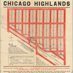
This is a rare and intriguing 1923 map of lots being sold at a real estate auction in Maspeth, Queens, New York City.
The map, oriented towards the west-northwest, covers a portion of the Second Ward of Queens, which here is referred to as Long Island City but which today is squarely in the middle of Maspeth, between the Mt. Zion and Mount Olivet Cemeteries. Existing buildings and lots to be auctioned are labeled on the map, along with rail and trolley lines and streets. Street names have nearly all changed, mainly to a numbered system of streets and avenues, though Borden Ave. and Clinton Ave. still exist (the latter seemingly following a different route than that seen here, suggesting another street was assigned this name at some point). A central selling point of the lots emphasized on the verso is the relative proximity to the “Bliss St. subway station,” today the 46th St. – Bliss St. station local stop on the 7 train (IRT Flushing Line).
The trolley seen on Borden Ave. (photographed on the verso) ran all the way from Hunter’s Point to Flushing, mainly along a dedicated right-of-way, allowing for relatively fast speeds. The route was especially popular among Manhattanites visiting deceased relatives at the nearby cemeteries (they arrived by the ferry marked on the verso before hopping aboard the trolley). The trolley route later provided the right-of-way for the Long Island Expressway, which runs right next to Borden Ave. When the Queens Midtown Tunnel opened in 1940, a highway (the Queens Midtown Expressway) connected it to Laurel Hill Boulevard, just to the west of the area seen here. By then, the trolley had already stopped operating, and, after an interruption due to World War II, planning and construction began on extending the highway (later designated I-495) through to Maspeth in the early 1950s using the trolley route.
The verso includes a map of the wider area with the lots for sale marked out, promotional text, and photographs. Overall, they give a sense of both the relative lack of development of this part of Queens at the time and the rapid pace of new construction and an infectious sense of opportunity and dynamism. The population of New York City had exploded in the preceding decades and, combined with increasing wealth and better mass transportation, meant that those with the means sought to escape the densely-populated city for new suburbs. This portion of Queens, which had mostly been farmland only twenty years prior, was rapidly developed, largely thanks to the IRT line to Flushing. Though the area has changed tremendously since this promotional map was produced, the elevated tracks for the line and the nearby shops along Queens Blvd., as seen in one photograph, are still easily recognizable today.
Census
This map was originally prepared by City Surveyor Robert E. Carlin and guaranteed by the Title Guarantee and Trust Company. It was then modified by Joseph P. Day, a prolific and legendary property auctioneer in the city, who added the promotional text and images around the map and on the verso.
Although other similar auction maps from Joseph P. Day appear in the institutional holdings of the New York Public Library, Columbia University, and Library of Congress, no other examples of this work are known to exist in institutional holdings or on the market.
Cartographer(s):
Joseph P. Day was a pioneering figure in New York City’s real estate industry during the early 20th century, renowned for revolutionizing the real estate auction business. Born in 1874, Day founded Joseph P. Day Realty and became famous for conducting massive, highly publicized property auctions that often sold entire city blocks in a single day. His innovative marketing strategies and ability to attract large crowds transformed real estate auctions into major events, earning him the nickname “the Prince of Auctioneers.”
Day played a crucial role in the development of key Manhattan neighborhoods, including parts of the Upper West Side and Harlem, significantly shaping New York City’s growth. His most notable achievement was the 1920 sale of the entire Bronx Park residential district in a single auction. Even during the Great Depression, Day remained an influential figure in real estate, leaving behind a lasting legacy when he passed away in 1944.
Condition Description
Wear and soiling along folds with some splitting and tape repairs, minor water staining.
References

![[Untitled] Portraits and facsimile signatures of 48 American patriots.](https://neatlinemaps.com/wp-content/uploads/2024/05/NL-01743_thumbnail-300x300.jpg)
![[First State] Panorama of the Seat of the War Birds Eye View of Virginia, Maryland, Delaware and the District of Columbia](https://neatlinemaps.com/wp-content/uploads/2024/05/NL-00664-scaled-1-300x300.jpg)
![[First State] Panorama of the Seat of the War Birds Eye View of Virginia, Maryland, Delaware and the District of Columbia](https://neatlinemaps.com/wp-content/uploads/2024/05/NL-00664-scaled-1.jpg)