Berkeley’s transformation from rural town to bustling university city.
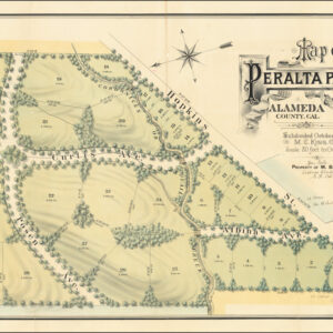
Map of Berkeley, California. W.F. McClure, City Engineer. Patterson, Smith & Co., Inc., successors to R.R. Patterson, Real Estate and Insurance, 2107 University Avenue … General agents for Claremont Heights Tract.
$575
1 in stock
Description
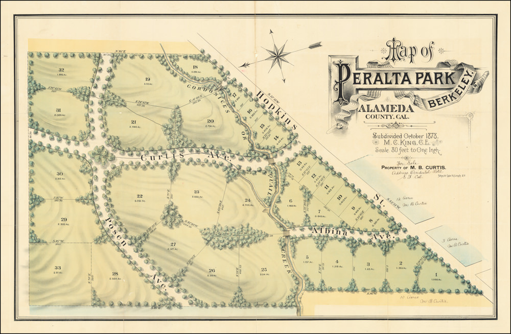
This early cadastral map of the Downtown Berkeley area was published in 1910 by Patterson, Smith & Co. in Oakland, California. The maker was Wilbur F. McClure, City Engineer of Berkeley. Published as an independent sheet, the map measures 22 x 28.75 in and was drawn to a scale of 1:11,500. It provides a comprehensive view of what today has become the heart of Berkeley and shows the expanding town’s land development opportunities at the time. Indeed, a subtitle for the map is “Choice Villa Sites,” intimating the type of clientele that Patterson, Smith & Co. were targeting.
The area in question was Claremont Heights (known today as Claremont Hills). Following the establishment of the Claremont Hotel and Country Club in the early 1900s, this rural area on the outskirts of Berkeley was quickly transformed into an upscale residential neighborhood. This new area is located on the main map at the southeast periphery. However, a more comprehensive cadastral view is provided on the verso of the map.
The main map is highly detailed and includes tract boundaries, block numbers, major landowners, and a comprehensive street index. Of historical interest are the old ward boundaries, which are delineated and labeled on the map. Adorning the center of it all is UC Berkeley’s gorgeous campus, which opened in 1869.
The map’s verso features a more focussed cadastral map titled Claremont Heights Subdivision No., which emphasizes the development of villa sites in Berkeley’s new neighborhood. It provides potential buyers details such as lot numbers, plot dimensions, streets, and sewer lines.
Census
This 1910 edition of McClure Map of Berkeley was printed as part of a promotion of the new Claremont Heights neighborhood in the Berkeley Hills. As far as we have been able to ascertain, the earliest state of the main Berkeley map dates to 1906. The Bancroft Library holds an example of this map and is accessible via the Online Archive of California (Local Call no. Map G 04364 B5 1906 M3 Case XB Bancroft).
With its explicit promotion of the Claremont Hills, the current map was an update to the 1906—and thus pre-earthquake—edition. The verso shows the addition of the more focussed cadastral map. This particular edition is found in multiple US institutions, including the David Rumsey Map Collection held at Stanford University (List no. 5317.001) and the university libraries of Brown, Cornell, Oberlin College, UC Berkeley, and UC San Diego (OCLC no. 62147446).
Context is Everything
Berkeley experienced significant urban development from the late 19th and early 20th century, transforming it from a small rural community into a bustling city by the end of World War 1. In the 1870s, the establishment of UC Berkeley acted as a catalyst for the city’s growth, attracting residents, businesses, and infrastructure to the area. The construction of the first streetcar line in 1873, which connected Berkeley to Oakland and San Francisco, further spurred residential and commercial development. By the late 1880s, Berkeley was officially incorporated as a town. Its population rapidly expanded due to the increasing demand for housing and services related to the university and its growing student body.
Berkeley continued to grow into the early 20th century, albeit now with a greater focus on organized urban planning and the development of public amenities. This period was marked by introducing significant infrastructure projects, including developing an extensive streetcar system and facilitating more accessible access to various parts of the Bay Area. The city also saw the construction of notable buildings such as the Berkeley City Hall, completed in 1909, and several public schools that reflected a new commitment to education. Residential neighborhoods expanded rapidly, with new subdivisions emerging to accommodate the influx of residents. The Berkeley Hills area became desirable, offering picturesque views and a retreat from the more densely populated flatlands.
The Claremont Hills area, located in southeastern Berkeley, played a crucial role in the city’s urban development during this period. Initially a rural area, Claremont Hills was transformed into a residential neighborhood in the early 1900s following the establishment of the Claremont Hotel and the Claremont Country Club. The development was spearheaded by real estate promoters and civic leaders who saw the potential for creating a high-end residential community. The Claremont Heights Subdivision No. 1, as seen on the 1910 map of Berkeley, represents one of the earliest planned subdivisions in this area, featuring carefully laid-out streets and modern amenities.
Cartographer(s):
Patterson, Smith & Co. was a prominent early 20th-century printing and publishing company operating out of 2107 University Avenue in Berkeley. The company produced high-quality maps, brochures, and other printed materials. Patterson, Smith & Co. played a crucial role in documenting the rapid growth and urbanization of Berkeley and surrounding areas. Their publications, often created in collaboration with city officials and engineers like Wilbur F. McClure, provided detailed information on land development, infrastructure, and real estate opportunities.
Wilbur Fiske McClureWilbur Fiske McClure (1856-1926) was a distinguished civil engineer whose career included various significant roles in developing California’s urban and state infrastructure. Born in Ohio and raised in Pennsylvania, McClure got his first surveying experience as a railroad engineer, working across several states before settling in California in 1883. Once living in California, he contributed to numerous railroad, marine, and municipal projects, eventually becoming the City Engineer of Berkeley. His tenure in Berkeley coincided with rapid urban transformation, allowing him to lay much of the groundwork for the city’s modern layout and infrastructure.
In 1912, McClure was appointed State Engineer of California by Governor Hiram Johnson. McClure served in this capacity for over a decade and was a central figure in developing California infrastructure. This included serving as California’s representative on the Colorado River Commission, where he was a signatory on the Colorado River Compact. Later, McClure also worked as Commissioner of Public Works. The large Lake McClure, created by the construction of the Exchequer Dam on the Merced River, is named after our mapmaker, the state engineer at the time of the dam’s construction.
Condition Description
Wear and tape repairs along folds with some loss.
References