An American Mizrach print with Zionist undertones.
[Mizrach] Map of Palestine.
Out of stock
Description
Envisioning a Jewish Homeland before the Holocaust.
This vibrant poster of The Holy Land was produced in the Zionist circles of early 20th-century New York. It centers on a map of Palestine subdivided between the Twelve Tribes of Israel, each identified in the associated legend. The map is extensively labeled in Hebrew and includes new settlements and ancient features, such as the route taken by the Israelites in their iconic flight from Egypt.
The central map is surrounded by colorful and deeply symbolic vignettes of essential places for Jews in Palestine. Along the top register, we see vignette views of Jaffa (Tel Aviv) and Haifa on either side of a schematic representation of Solomon’s Temple in Jerusalem. Flowered vases, common Jewish symbols of abundance, intersperse the architectural views. The title at the top of the poster reads Mizrach or East, with the word Jerusalem in Hebrew and Latin letters on either side.
Flanking the main map, we have another two city views showing Tiberius and Saffed, respectively. The depicted towns and cities were essential to the Jewish historical identity. However, more critical to the context of this print was that they housed a growing number of Jewish inhabitants, many of whom were immigrants from Europe. The affiliation with ancient sites mentioned in the Torah also carried a modern connotation in that it connected the return of Jews to their ancient homeland. This underlying Zionism is especially stressed by the two vignettes above Saffed and Tiberias. On either side of the map, an arch held up by massive pillars frames a numbered list in Hebrew. The headline reads Jiddische Kalanien or Yiddish Colonies, indicating the location of new Jewish settlements in Palestine to which the persecuted Jews of Europe were returning.
In the bottom register, we have additional pictorial representations of holy sites: Abraham’s Tomb in Hebron and King David’s Tomb in Jerusalem. Above both, a Star of David is surrounded by the word Zion in Hebrew.
Context is Everything
The title of this lithograph, Mizrach, meaning East, carries several implications. Jewish law dictates that Jews at prayer should face the site of the Temple in Jerusalem, which in European and American contexts typically meant to the east. In a synagogue, the appropriate direction is usually apparent from the orientation of the building and the placement of the Torah ark. However, in the private homes of Orthodox Jews, the correct direction will often be indicated by a decorative plaque or printed sheet marked with the word Mizrach. Frequently, the word is complimented with scriptural passages or images of holy sites, as is the case on this map.
Following the Dreyfus Affair in France (1894) and repeated pogroms in Russia, Ukraine, and the Pale (Lithuania, Poland, Belarus, etc.), statehood seemed to many European Jews as the only solution to centuries of persecution. The exodus of thousands of eastern Jews to America and Palestine in the late 19th century meant a revival of Jewish traditions in these places, including a notable increase in the number and variety of printed Mizrach signs. This elaborate Mizrach represents an explicitly Zionist orientation, labeling Palestine as Eretz Israel and highlighting the early Jewish colonies.
American Philanthropist William Gross, who accumulated an enormous collection of Judaica known as the Gross Family Collection, makes the following observation regarding Mizrach prints and his copy of this scarce poster: “The four letters of the Hebrew word MiZRaCH are sometimes indicated as the initial letters of the Hebrew phrase Metzad Zeh Ruach Chaim (From this side the source of life).”
Census
The present Mizrach lithograph was created by an unidentified Jewish artist and printer in New York. It was initially published in 1914 and then reprinted in 1936-37 (תרצז). Neatline’s example is dated accordingly under the list of Yiddish colonies.
We have identified one parallel in the Gross Family Collection (ID. 056.011.009), held by the Center for Jewish Art at the Hebrew University of Jerusalem (Obj. ID: 56386). While many Mizrach prints are similar to this and from the same period, we have not identified further examples in institutional collections or on the market.
Cartographer(s):
Condition Description
Professionally backed, with repaired tears and some infill, mainly in the margins.
References
Related products
-
-
Add to cart

- Eastern Mediterranean - Holy Land
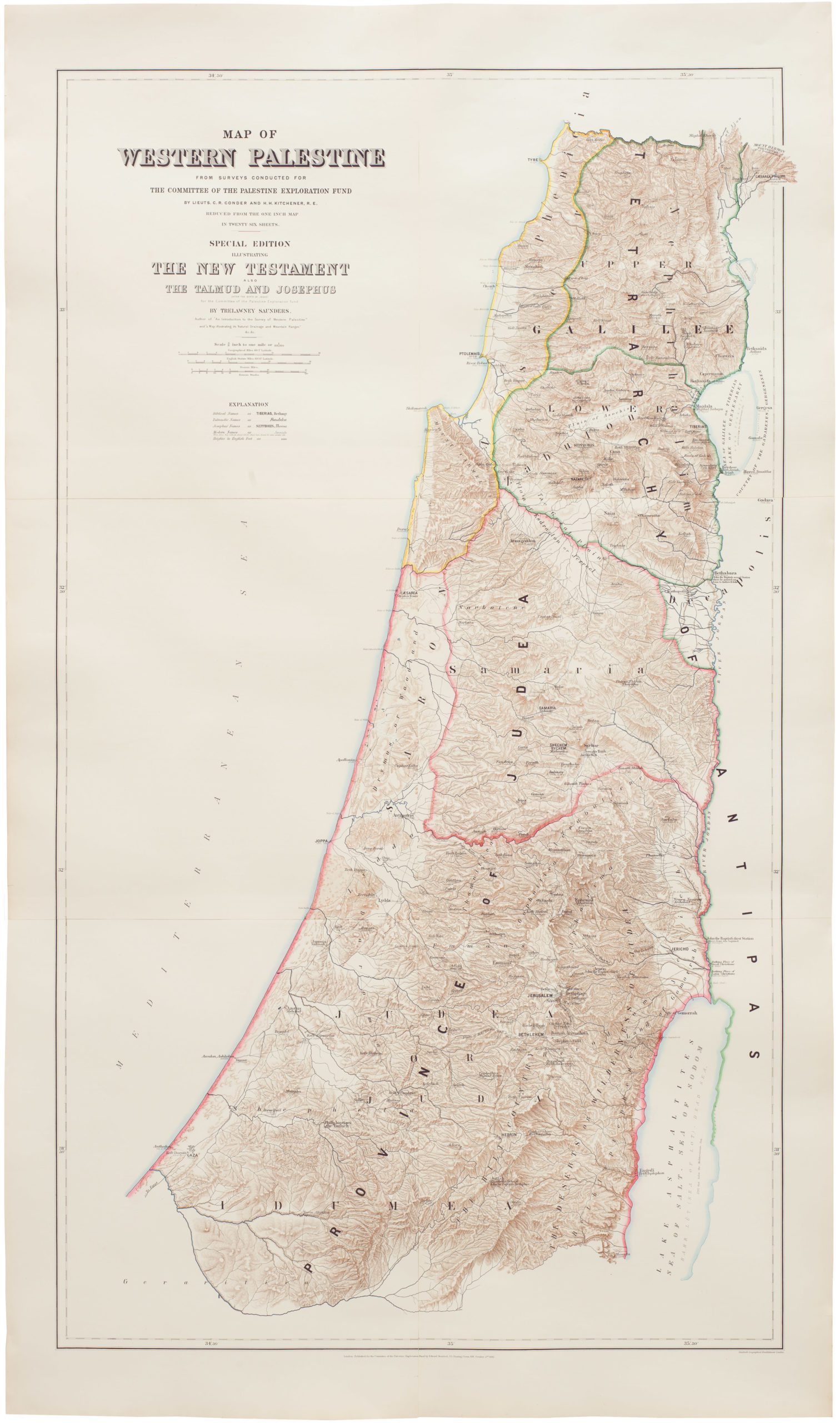
Map of Western Palestine from surveys conducted for The Committee of the Palestine Exploration Fund. By Lieuts. C. R. Conder and H. H. Kitchener, R. E. Reduced from the one inch map in twenty six sheets. Special Edition Illustrating The New Testament also The Talmud and Josephus (after the birth of Jesus)…
- $1,000
-
-
-
![[Mısır Haritası / Map of Egypt]](https://neatlinemaps.com/wp-content/uploads/2025/06/NL-02391_thumbnail-2-300x300.jpg)