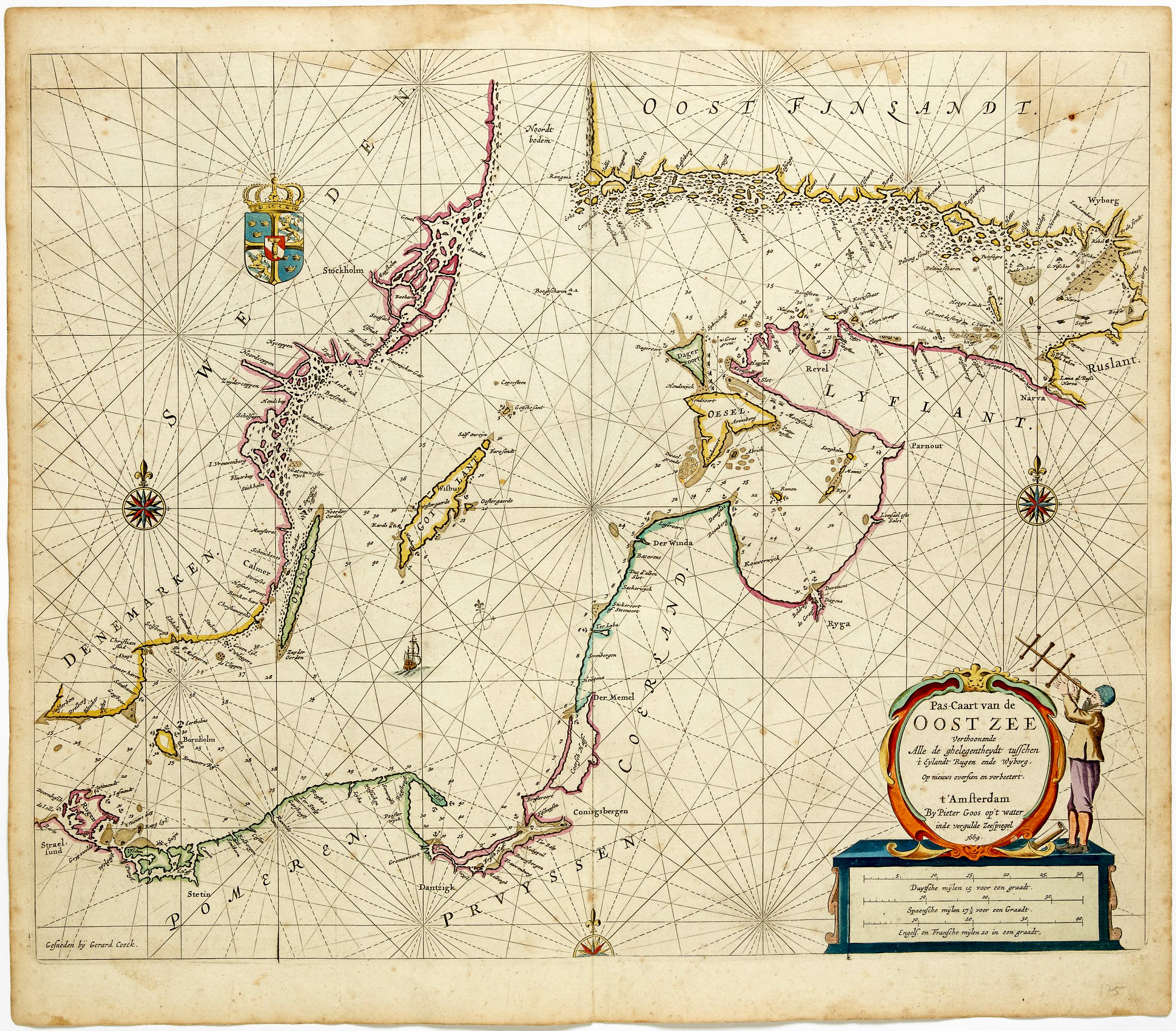
1693 Collins Nautical Chart of Dublin Bay, with Detailed Plan of the City.
[Dublin Bay]
$1,000
1 in stock
Description
Dublin at the Close of the Seventeenth Century.
This chart of Dublin Bay and its approaches, from Captain Greenville Collins’s Great Britain’s Coasting Pilot of 1693, is among the most distinctive plates in the atlas. Oriented north-east rather than north, it combines a careful hydrographic survey of one of the most navigationally demanding harbor approaches in the British Isles with what is one of the most elaborate urban plans in the entire Coasting Pilot, a vivid record of Dublin’s built fabric at the close of the seventeenth century. It is dedicated to His Grace James Butler, second Duke of Ormond, Lord Lieutenant and General Governor of Ireland, one of the most powerful figures in Restoration and post-Revolution Ireland, whose patronage places the chart under the protective authority of its highest civil and military officer.
The Map in Detail
The North Bull and South Bull sandbanks frame the main channel into the River Liffey and are both prominently labeled and carefully sounded, their positions reflecting the twin hazards that defined the port’s navigational character. Howth Head is shown to the north with its rocky peninsula, and the surrounding villages of Dalkey, Merrion, Sutton, Clontarf, Kilbarrack, and Monkstown are marked along the shore, giving the chart an unusual degree of terrestrial specificity. Dublin itself occupies the western margin, depicted in a relatively detailed plan showing the street grid, the quays, and the principal public buildings. Dalkey Sound, with its island anchorage, receives its own soundings in the south-east corner, acknowledging its role as an alternative shelter when the bar at the Liffey mouth made direct entry impossible. The cartouche in the upper left is among the most festive in the series, a horizontal frieze in which swirling allegorical figures, sea deities and putti, are set amid waves and drapery supporting a flowing ribbon bearing the chart’s dedication.
Historical Context
Dublin Bay presented the approaching mariner with a deceptively dangerous threshold. The North and South Bull sandbanks, constantly shifting with the tidal action of the Liffey and the Bay, constricted the navigable channel and could strand or wreck vessels that misjudged the bar, particularly in onshore winds. The alternative anchorage at Dalkey Sound, noted on the chart, was a well-established refuge for vessels waiting for favorable conditions to attempt the Liffey entrance, and Collins’s decision to sound it separately reflects an understanding of the port’s practical rhythms. The plan of Dublin is among the most remarkable incidental features in the Coasting Pilot. By 1693 Dublin was the second city of the British Isles and had undergone substantial expansion in the decades since the Restoration, with new quays, public buildings, and street improvements transforming the medieval city. Collins’s chart preserves its appearance at precisely the moment when that transformation was most active. The dedication to James Butler, second Duke of Ormond, connects the chart to the highest tier of Irish political authority. Ormond served as Lord Lieutenant of Ireland under both William III and Queen Anne, and his family’s dominance over Irish political life in this period was unmatched. His patronage of Collins’s chart was both a practical endorsement and a political statement, placing the hydrographic record of Ireland’s principal harbor under the authority of the man responsible for its governance.
Publication History and Census
This chart appears as a plate in Great Britain’s Coasting Pilot, first published in London in 1693. The plates were reprinted throughout the eighteenth century by the Mount publishing dynasty, first as Mount & Page and later as Mount & Davidson, and surviving sheets are most commonly encountered as individual disbound leaves.
Cartographer(s):
Captain Greenville Collins (c. 1643–1694) was an English naval officer and pioneering hydrographer whose work laid the foundation for systematic coastal charting in Britain. Serving in the Royal Navy during the late seventeenth century, Collins gained practical experience in navigation and surveying at a time when reliable nautical charts of British waters were scarce. Recognizing the strategic and commercial importance of accurate maritime information, the English crown commissioned him in the early 1680s to conduct a detailed survey of the coasts of England and Wales.
Between roughly 1681 and 1688, Collins directed an extensive hydrographic survey of the English coastline, measuring depths, mapping shoals and sandbanks, and documenting harbors and navigational hazards. His work represented one of the first coordinated national charting efforts in England. The results were compiled into Great Britain’s Coasting Pilot, first published in 1693. The volume combined detailed engraved charts with sailing directions and coastal views, providing mariners with far more reliable guidance than previously available.
Collins’s atlas became the standard reference for navigation around British waters for decades and marked an important step in the professionalization of hydrography in England. His methods and charts influenced later surveying practices and helped improve maritime safety during a period of expanding naval power and overseas trade. Collins died in 1694, only a year after the publication of his landmark work, but his contributions established him as one of the earliest significant hydrographers of the British Isles.
Condition Description
Wear along the centerfold and margins. Image is nice.
References