Thematic mapping for children: a fabulous circa 1930 world map depicting the history of exploration.
Cassell’s Children’s Book of Knowledge Wonder Map of the World.
$750
1 in stock
Description
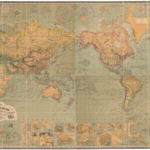
This is an unusual and rare thematic world map, presenting many of history’s greatest sea voyages of discovery in graphic form. It is an Interwar map, published in London some time in the late 1920s or early 1930s. As such, it is an important contribution to a variety of cartographic genres: early thematic mapping, pictorial mapping, and maps designed specifically for children.
Long before the Internet and Wikipedia, knowledge was consolidated in encyclopedias, almanacs, and multi-volume histories. One such work was Cassell’s Children’s Book of Knowledge. This world map formed part of that corpus. It is bold and well-executed, and surely drew the immediate attention of its young readers. The central portion of the work consists of the map itself, with illustrations of fauna, basic geographic features in the landscape, and sailing ships with their tracks.
Two legends on either side of the map at center inform us that the ship routes correspond to voyages of exploration, starting of course with Columbus in 1492-3 and ending with Shackleton in 1909. Over twenty courses are plotted, including those of Vasco da Gama, Magellan, Sir Francis Drake, Abel Tasman, and all three of Cook’s expeditions. More recent voyages, for example the first steamships to cross the Atlantic in 1838, or important polar explorations by Ross, Nansen, and Peary, are also shown. Two circular insets display the routes of arctic and antarctic explorers. The list is thus quite comprehensive, especially given the format.
The most striking feature of the map are its circular medallions at top and bottom. Those along the top contain portraits of history’s greatest explorers, some the same as those mentioned on the map, but with new ones as well, including: Marco Polo, Sir Walter Raleigh, and leaders of expeditions in Africa like John Lander, David Livingstone, and Henry Morton Stanley. The title at the top of the map reads ‘Links in the Chain of Discovery,’ and a chain-link motif forms the ornamental border, much in the style of the 16th century Dutch strapwork motifs found on maps from an earlier era.
Another set of circular medallions along the bottom edge juxtaposes with the explorer portraits. This set features images of children from different nations throughout the world, dressed in traditional garb. One can imagine that this was perhaps the most compelling aspect of the map for its young audience.
Cartographer(s):
Condition Description
Some discoloration, repairs visible on verso.
References