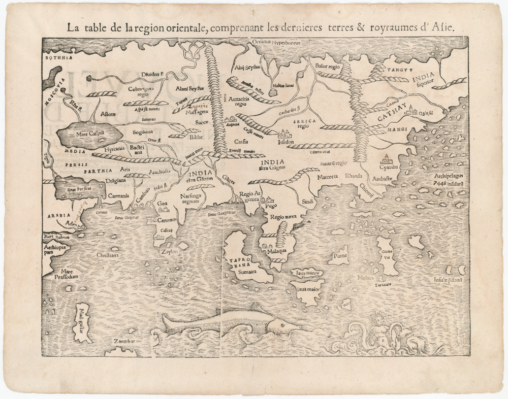
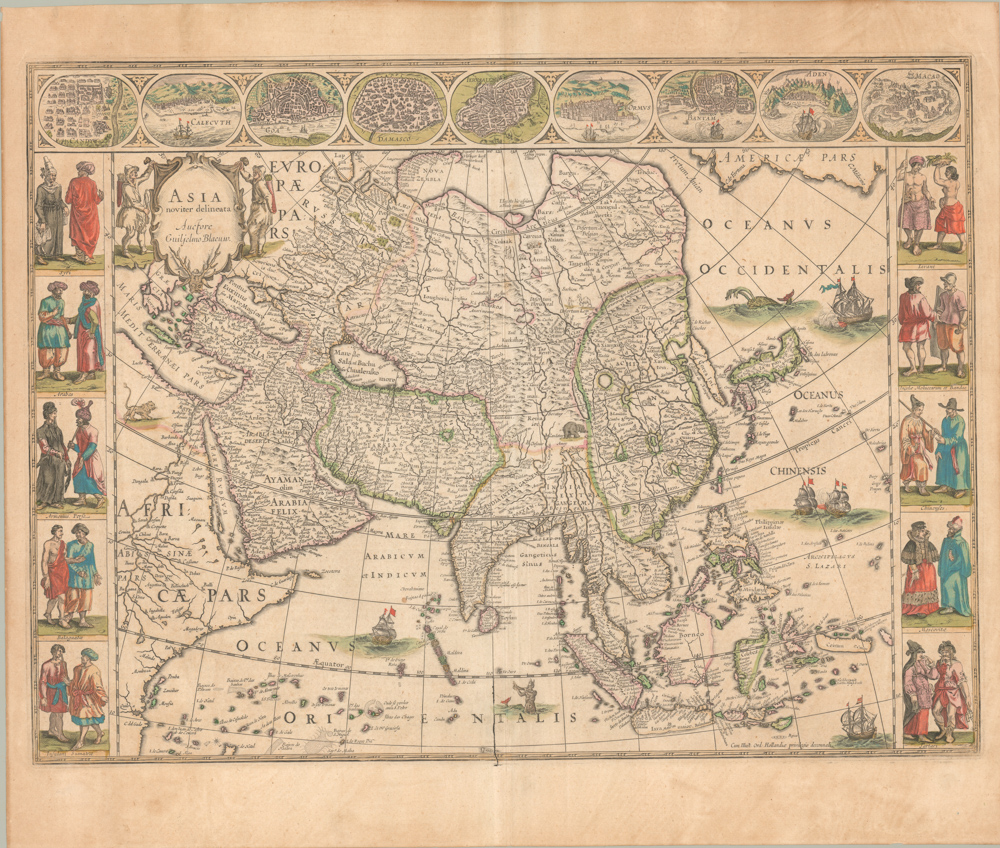
From History’s First Modern Atlas: a gorgeous Ortelius map of Asia with references to Marco Polo.
Tartariae Sive Magni Chami Regni Typus.
Out of stock
Description
Undoubtedly one of the most interesting atlas maps produced by Ortelius, this map is focused on northeastern Asia, but it is also an important depiction of western north America; among the place names in the latter is Cape Californio (at the tip of Baja) and Sierra Nevada along the coast.
Burden notes that “Unlike his map of America, this derives its cartography from Ortelius’ own large world map of 1564. This is a very early depiction of the northern Pacific. Its main feature is the STRETTO DE ANIAN. This increased the public awareness of the 1561 Giacomo Gastaldi theory of a strait between the continents of Asia and America.
At its southern entrance an enlarged Japan dominated, below which a note states that a large amount of the information in Asia emanates from the writings of Marco Polo. The west coast of North America differs from his map of America in that the peninsula is broader, some different names appear, and others are lacking.”
The map includes a very curious early treatment of Japan and marvelous detail in Tartary, Asian Russia and China, including Marco Polo & Prester John notes, several vignettes, 2 decorative cartouches, sailing ships and sea monster. Several vignettes depict the tents of the Tartar kings. The map is richly annotated in Latin, including some of the lengthier quotes, which have translated from Latin to English below:
The Nephalites are named Neptali after one of the 10 tribes with a Hebrew name, and after the Danites, who by way of punishment were called the Danes of the dark North, and they were on account of the claims of Rachel Balbah placed to the side, in the area of the Hudores or Iehudeores; in the year 476 they were victorious in their battle against Perosa. Others call them incorrectly Euthalites.
The Scythian ocean, according to Plinius, has sweet water, and he also says it contains many islands, as M. Paulus [Marco Polo] also says, but neither of the two tells about their number or location.
Tabor or Tybur, center of the area of the Tartars, where once the Holy Books got lost, yet they are united under one king, who in 1540 first reached France and king Franciscus, and later, at the initiative of Charles the Fifth was burnt at the stake for his heresy, because he had secretly endeavoured to convert Christian kings to the Jewish religion, about which he had spoken with Charles the Fifth.
Here the ten tribes retreated, and changed from the Tatar or Tartar area to Scythia. Since then they are called Gauths or Gauthens, confirming Gods highest glory, and here lies the splendid kingdom of Cathai.
Turkestan. The area from which the 10 tribes as allies living on this side of the mountain range have been called 900 years ago by the Persians to fight the armies of Ismael the Muslim.
The great Khan (which in the language of the Tatars means emperor), the highest ruler of Asia.
Argon. Once there was in Asia a Christian kingdom, known to Prester John, and D. Thomas founded it [this city] in this place, so that it was in contact with the church of Rome, and was subjected to Rome through Prester John of Africa. Before it was defeated by the Goths, it was known as Crive Romove.
This map contains the area of Tartaria, with the remaining part of East Asia to the Morning Ocean, subject to the great Khan whose might is bounded by the river Ob, Lake Kataia, the Volga, the Caspian Sea, the river Chesel, the mountains of Usson, the area of Tibet, the river Caromora and the Ocean.
The isle of Japan, called Zipangri by Marco Polo of Venice, formerly [called] Chrÿse, once attacked by the great Khan in war, but without success.
Latin text on verso, with folio No. 108. Engraved by Franz Hogenberg.
Watermark: Horn.
Cartographer(s):
Abraham Ortelius (1527-1598) was born in Antwerp to Flemish parents in 1527. After studying Greek, Latin, and mathematics, he and his sister set up shop as book dealers and a ‘painter of maps.’ In his heart, Ortelius was, nevertheless, first and foremost a historian. He believed geography was the ‘eye of history,’ which explains why he collected maps and historical documents with such passion. Ortelius traveled widely in pursuit of his interests, building contacts with mapmakers and literati all over the European continent.
Ortelius reached a turning point in his career in 1564 with the publication of a World Map in eight sheets, of which only a single copy survives. In 1570, he published a comprehensive collection of maps titled Theatrum orbis terrarum (Theatre of the World). The Theatrum is conventionally considered the first modern-style atlas. It was compiled by collecting maps and charts from colleagues across the continent, which Ortelius then had engraved in a uniform size and style. The engraver for most of the maps in Theatrum was none other than the famous Frans Hogenberg, who also served as the main engraver for the 16th-century urban atlas Civitates Orbis Terrarum, published with Georg Braun in 1572.
Hogenberg’s re-drawn and standardized maps formed the basis of the first atlas in history (even though it was Mercator who was the first to use the term a few decades later). Unlike many of his contemporaries, Ortelius noted his sources openly and in the first edition, acknowledged no less than eighty-seven different European cartographers. This ‘catalogus auctorum tabularum geographicum‘ is one of the major innovations of his atlas. The list of contributing mapmakers was kept up-to-date for decades after Ortelius’ death. In the first edition of 1570, this list included 87 names, whereas the posthumous edition of 1603 contained no less than 183 names.
While compiled by Abraham Ortelius in the manner described above, the Theatrum was first printed by Gielis Coppens van Diest, an Antwerp printer experienced with cosmographical books. Van Diest was succeeded by his son Anthonis in 1573, who in turn was followed by Gillis van den Rade, who printed the 1575 edition of Ortelius’ atlas. From 1579, Christoffel Plantin took over, and his successors continued to print Theatrum until Ortelius’ heirs sold the copperplates and the publication rights to Jan Baptist Vrients in 1601. In 1612, shortly after Vrients’s death, the copperplates passed to the Moretus brothers.
Condition Description
A few tape remnants at edges from earlier matting, lower left corner chipped well away from image; else excellent.
References
Burden 41; Wagner NW Coast 81; Wheat Transmississippi 16.
![[Pair of views] Rade et Ville de Sincapour & Rade de Sincapour prise de la maison du Gouverneur](https://neatlinemaps.com/wp-content/uploads/2021/03/NL-00896-harbor_Thumbnail-300x300.jpg)
![[Pair of views] Rade et Ville de Sincapour & Rade de Sincapour prise de la maison du Gouverneur](https://neatlinemaps.com/wp-content/uploads/2021/03/NL-00896-harbor_Thumbnail.jpg)