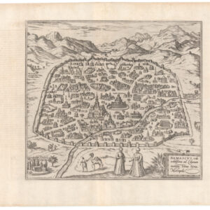
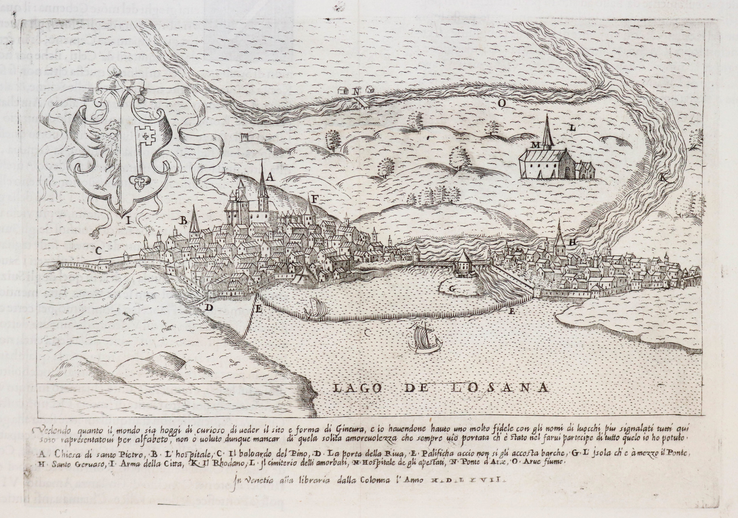
Lafreri-school 1568 Zenoi reverse-image bird’s-eye-view of Istanbul.
Costantinopoli città principale del gran turcho
$1,700
1 in stock
Description
This is Domenico Zenoi’s 1567 scarce engraved bird’s-eye view of Istanbul or Constantinople. Originally prepared for Paolo Forlani’s 1567 Primo libro, this example is likely from Bertelli’s 1568 Civitatum…delineatio (evidenced by the plate number 66 in the lower right corner). It would make a fantastic addition to any Constantinople collection or for collectors interested in the history of 16th century Italian engraving and publishing.
This rare town-plan and bird’s-eye-view presents the city from the east, looking towards Europe from the Asian coast of the Bosphorus. Notes in Italian mark the locations of castles and fortifications, major gates in the city wall, temples (mosques), palaces, and geographic features. Illustrations depict the larger buildings and structures, as well as a multitude of ships in the Bosphorus.
The view is modelled on a woodcut by Giovanni Andrea Vavassore. Instead of using the model to make an inverse on the copperplate, the engraver seems to have copied the image directly; thus when the image was pressed, it appears itself in reverse. Place names and descriptions were then added afterwards. Thus, the production of this single map represents the complex transition from woodcutting to copperplate engraving that was underway at the time.
This map was engraved by Domenico Zenoi c. 1567 for Bertelli’s 1568 Civitatum…delineatio. In the title frame sits a second line cum privilegio and in the lower left corner the engraver’s signature D.nco Zenoi. The work is often credited to Giovanni Francesco Camocio as it also appeared in his c. 1570 Isole famose, porti, fortezze, e terre maritime, later republished by Bertelli, who inherited Camocio’s plates after the latter’s death c. 1575.
Cartographer(s):
The Bertelli family represents the largest group of publishers, engravers, cartographers, and merchants of 16th century prints. The most productive was Ferrando Bertelli, active between 1560 and 1570, but maps of the last quarter of the century are known with the signatures of Andrea, Donato, Lucca, Nicolò, and Pietro. The latter was mainly active in Padua, where he led a printing and engraving workshop.
Donato Bertelli (active 1558-1592) was a Late Renaissance printer, publisher, and mapmaker. Operating under the banner of San Marco in Venice, Bertelli was one of the more prominent members of the ‘Lafreri School’ of cartography working out of Rome and Venice during the 16th Century.
Although born in Padua, Donato Bertelli moved to Venice as a young man and spent his entire career there. In 1559, shortly after first arriving in town, he found work in Ferrando Bertelli’s workshop. When Ferrando died, Donato either took over the entire shop or at least acquired his plates, which he then used to launch his publishing career. Donato Bertelli would also publish plates from other Lafreri mapmakers, including Forlani and Camocio, and would often make the prints his own by adding personal elements.
Condition Description
A few worm holes in lower right margin. Light water staining in right margin. Very fair impression and printed on heavy paper.
References
Bilfolco TAV. 169.
Meurer, Peter H. The Strabo Illustratus atlas: a unique sixteenth century composite atlas from the house of Bertelli in Venice. Bedburg-Hau: Antiquariat Gebr. Haas, 2004, #132.