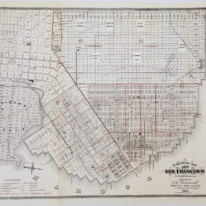
Scarce 1881 atlas map of San Francisco divided by wards
San Francisco
Out of stock
Description
Detailed map of San Francisco extending from Presidio Reservation to Visitation Valley. It is hand colored by wards and shows streets, docks, wharfs, railroad lines, street car lines, parks and many other details.
Many interesting early landmarks are depicted, including the Ocean House Toll Road, Bay View Race Course, Industrial School, and more.
This is the earliest full-page map of the city of San Francisco to appear in a commercial atlas, one of the few examples we have seen on the market in the past 10 years. Published in Gray’s The National Atlas.
Cartographer(s):
Condition Description
Some minor foxing.
References
Ristow, Walter W. American Maps and Mapmakers: Commercial Cartography in the Nineteenth Century. Detroit, MI: Wayne State University Press, 1985; pp. 427-9.
![Inside [San Francisco]](https://neatlinemaps.com/wp-content/uploads/2019/11/NL-00737-scaled-300x300.jpg)