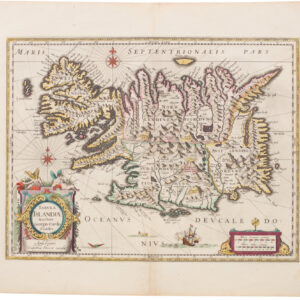
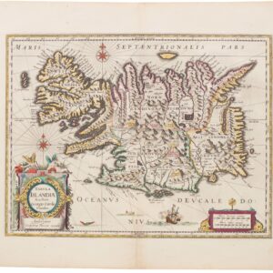
Nautical chart of the British Isles with original coloring heightened in gold leaf.
Pascaart vant Canaal, Tusschen Engelant en Vrancryck, alsmede ge heel Ierlant en Schotlant
$625
In stock
Description
This is an early sea chart of the British Isles, created by the seminal Jan Janssonius and featuring stunning coloration highlighted with gold leaf. The chart, which is distinctly nautical in both appearance and nature, depicts the British Isles almost in their entirety and is oriented with east at the top. The only part of the English landmass that is not visible is hidden behind the stunning title cartouche.
The chart showcases the coastal waters surrounding the British Isles, northern France, and Ireland. Among the depicted lands are the many smaller and larger islands in the coastal waters surrounding Britain. Especially the islands of Scotland’s western archipelago have been rendered in high definition.
A beautifully adorned title cartouche at the bottom of the chart features Neptune, a river goddess, and the royal coat of arms. Being a sea chart, the map naturally includes rhumb lines, compass roses, and engraved details pertaining to the coastlines, complemented by original hand-colored outlines. The cartouches are as exquisitely colored as they are carved, adding to the map’s aesthetic appeal.
Jansson’s chart of the British Isles was based on Anthony Jacobsz Lootsman’s sea chart from 1644. It was issued in 1660 as part of Jansson’s notable nautical compendium: Atlantis Majoris Quinta Pars Orbem Maritimum seu, which served as the fifth volume of his renowned Atlas Novus.
Cartographer(s):
Johannes Janssonius (1588 – 1664; born Jan Janszoon, also Jan Jansson) was a Dutch cartographer and publisher who lived and worked in Amsterdam in the 17th century. Janssonius was born in Arnhem, the son of Jan Janszoon the Elder, a publisher and bookseller. In 1612 he married Elisabeth de Hondt, the daughter of Jodocus Hondius. He produced his first maps in 1616 of France and Italy.
In the 1630s, Janssonius formed a partnership with his brother-in-law Henricus Hondius; they published atlases as Mercator/Hondius/Janssonius. Under the leadership of Janssonius, the Hondius Atlas was steadily enlarged. After Janssonius’s death, the publishing company was continued by his son-in-law, Johannes van Waesbergen. The London bookseller Moses Pitt attempted publication of the Atlas Major in English but ran out of resources after the fourth volume in 1683.
Condition Description
Paper crease next to center fold. With the usual very light age toning of paper.
References
Shirley, 659.
![[Map of Steamship Routes and the Railways and Post Roads of the Russian Empire]](https://neatlinemaps.com/wp-content/uploads/2020/04/NL-00827_Thumbnail-300x300.jpg)
![[Map of Steamship Routes and the Railways and Post Roads of the Russian Empire]](https://neatlinemaps.com/wp-content/uploads/2020/04/NL-00827-scaled-300x300.jpg)