Map of the City of San Jose
$245
Scarce 19th century real estate promotional map of San Jose.
In stock
Cartographer(s):
Jas. A. Clayton & Co.
Date:
ca. 1888
Place:
San Jose
Dimensions:
24 x 32.7 cm (9.5 x 12.7 in)
Description
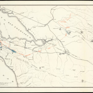
Scarce cadastral map of San Jose issued by the real estate company of James Clayton, announcing “Houses for Rent… Houses for Sale, Orchards, Farms, Lots: as well as Money to Loan at all times.”
The map shows radial distances from Santa Clara and First Streets, with buildings, city limits, various surveys, tracts, and subdivisions by name.
Census
OCLC/WorldCat locates two copies of the map, at Stanford and the University of California Santa Cruz, both dated 1888, and another, unfound copy dated to the1890s — the present example has a manuscript date 1901 inked at lower left.
Cartographer(s):
Condition Description
Some darkening, old folds; very good.
References
![The Original Silicon Valley Map & Calendar [1994]](https://neatlinemaps.com/wp-content/uploads/2021/06/NL-00909_Thumbnail-300x300.jpg)