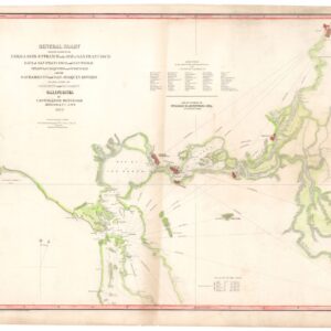
George Holbrook Baker’s 1855 letter sheet mining map of northern California.
Map of the Mining Region of California 1855. Drawn and Compiled by Geo. H. Baker
$8,500
1 in stock
Description
A landmark map for Gold Rush and California cartography.
Rare. Only one example outside of California.
Likely the first appearance of the Marin County town of Corte Madera on a printed map.
George H. Baker’s portrayal of the California mining region is one of the most detailed and accurate Gold Rush maps ever produced. It was lithographed by the Fishbourne company in San Francisco on blue-laid paper and issued as a letter sheet.
The map presents the gold-rich regions of northern California and an area stretching from the counties of Monterey and Lake Tulare in the south to Klamath and Siskiyou in the north. County names are printed in bold black letters ensuring an accessible overview when locating one’s intended destination. While state authorities were clambering to take a more significant stake in the state’s mining and prospecting licenses, at this early stage, rights and access to the prospecting areas were mainly issued on a county-to-county basis, making their immediate identification important.
A table at the center-right titled “Population of California 300,000” informs us of the population number for major towns. San Francisco leads the list with a population of about 50,000. In the upper right corner of the map is a “Table of Distances from the Capital Sacramento City” that lists the mileage from the new state capital to all the region’s principal towns. In the east, the map also includes a large portion of what today is Nevada, although it has been labeled Utah. The separation of Nevada from Utah did not happen until 1864, when creating a new state with its independent electorates helped ensure a second term for Abraham Lincoln.
The beginnings of Gold Rush cartography
Baker’s map of the California mining regions inscribes itself into a broader tradition of Gold-Rush cartography. The quintessential first mover in this regard was Edward Otho Cresap Ord’s Topographical Sketch of the Gold & Quicksilver District of California from 1848. This map was the first attempt to chart the new discoveries and was produced only shortly after the initial findings at Sutter’s Mill that summer. However, Ord’s map did not offer much detail and was quickly superseded by Lawson’s Map from Actual Survey of the Gold, Silver & Quicksilver Regions of Upper California, published in January 1849. Like Ord’s map, Lawson produced his map specifically for prospectors and miners, but unlike Ord’s, it included a range of new toponyms and the accurate location of ranches, gold strikes, trails, forts, and stores.
While the Gold Rush drew many would-be prospectors with little or no experience, it naturally attracted more professional surveyors and mining experts as well. This influx resulted in several more scientifically anchored publications and maps, with Philip Thomas Tyson’s Information in Relation to the Geology and Topography of California from 1850 being the leading publication. But these works were usually too detailed and expensive for the emigré prospector. Instead, simplified maps began to flood the market. A notable pioneer success in this regard was William A. Jackson’s Map of the mining district of California, which was first published in 1849. This map/booklet was crucial because it constituted the first dedicated miner’s maps of the region accessible to all. Jackson’s map not only started a new trend but also served as the direct inspiration for his initial competitors.
There can be little doubt as to the influence and popularity of Jackson’s map. Robert H. Ellis’ Map of the Gold Region of California, taken from a recent survey from 1850, blatantly copies Jackson but also updates and improves the design in terms of content and engraving quality. To distinguish it firmly from its predecessor, it even includes a gorgeous little vignette depicting a view of Portsmouth Square and San Francisco Harbor. The overlap in content between the Jackson and Ellis maps was not strange, as both maps were lithographed on the same New York street, only months apart.
To counter the attempts by others to supersede his pioneering map, Jackson published a second state in 1851, which was decidedly different from its predecessor and became even more popular. While our map postdates the second Jackson map by four decisive years, it is quite evident from the map’s features, subdivisions, and especially fonts that Baker used the second Jackson map as an overall template. Yet by the time Baker was working, the landscape of northern California had changed significantly, and being a local operative, Baker endowed his map with the latest pertinent information.
In what follows, we have highlighted three features of the Baker map and compared these to other California mining maps to elucidate where the Baker map fits in the chronology of Gold-Rush cartography.
Neue Helvetia, Sutter’s Fort, or Sacramento?
The California Gold Rush began with the discovery of gold at the mill of Swiss emigrant John Sutter in the summer of 1848. Sutter was an early California pioneer who had secured a large land grant near the branching of the Sacramento and American Rivers. He established a fort named after himself and a settlement called New or Neue Helvetia. The area between the settlement and the fort eventually became the site of the present-day city of Sacramento. Sutter’s son, John Sutter Jr., and Sam Brannan, the iconic newspaperman behind the California Star, founded the town in late 1848. The original plan, which Captain William H. Warner drafted, included 26 lettered and 31 numbered streets laid out in a grid.
The town was an immediate success, quickly eclipsing the other Sutter sites. The breakneck pace with which Sacramento developed during the early 1850s is reflected on contemporary maps, and Baker’s is no exception. Emigrant guides like those produced by Bruno Schmolder in the late 1840s and early 1850s consistently apply the old terminology of Neue Helvetia or Sutter’s Fort, and even well into the 1850s show no evidence of Sacramento’s existence. Other sources were far quicker to adapt to the changes. In 1850, before Sacramento’s city charter was recognized by the State Legislature, the aforementioned Geology and Topography of California by Philip Thomas Tyson constituted the first scientific work to focus on the Gold Rush. The maps it contained (mostly compiled by Lt. George H. Derby) consistently reference Sacramento and even depict its grid in the regional maps.
Jackson’s and Ellis’ maps, issued a year before Tyson’s seminal work, also depict Sacramento prominently. By the time Baker published his map, Sacramento had formally been recognized as the new state capital (1854). Baker himself became a Sacramento resident in 1852, which may explain the omission of any reference to Sutter’s iconic fort (although Sutterville has been included just south of Sacramento).
Views of the new town of Sacramento were also in circulation quickly. Among the earliest and most iconic vistas, we find G.V. Cooper’s Sacramento city, Ca. from the foot of J. Street, showing I., J., & K. Sts. with the Sierra Nevada in the distance, printed in New York as early as 1849. While this image captures Sacramento during its earliest days, it is quite clear that this is already an active and thriving community with bars and hotels, banks, a theatre, a gold exchange, shops and stores, and a significant number of ships mooring at the riverbank. While other views exist, Cooper’s early view was only replaced when Baker himself published an excellent bird’s eye view in 1857. By then, Sacramento had grown into a proper town that completely engulfed the sites established by John Sutter Sr. The pride felt at the city’s new status as the state capital is evidenced by thirty vignettes of Sacramento’s most prominent buildings surrounding the central view.
The Spectral Railroad from Benicia to Marysville
Another evocative detail that helps contextualize Baker’s map is the depiction of a railroad line between Benicia and Marysville. Benicia was founded in 1846. Located on the Carquinez Strait, it was considered an ideal node for transhipping between the northern California interior and the port at San Francisco. In 1851, engaged citizens began planning a railroad connecting Benicia to Marysville on the Yuba River. Surveyors began preliminary investigations the following year, but the project was never further developed, partly due to interest shifting to the Transcontinental Railroad instead. Baker’s inclusion of the line was probably intended as a foresight. But the project had been all but forgotten by the time the map was published.
The rapid development of the idea, and its equally rapid decline, meant that this particular railroad only figures on a handful of maps that all date to the first half of the 1850s. One famous parallel is John R. Bartlett’s 1854 map compiled for the United States & Mexican Boundary Commission. While this map focused on showing the United States’ new borders following the Gadsden Purchase and thus was produced at an entirely different scale than Baker’s work, it includes a thin line indicating the same railroad. As is often the case in cartography, there was a period in which other mapmakers adapted this “error” or “ghost” uncritically. Thus we find examples like the California map produced by Theodore Ettling and published in 1856 by The Weekly Dispatch in London, still including this line as a reality.
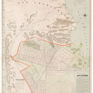
Marin and the northern California coastline
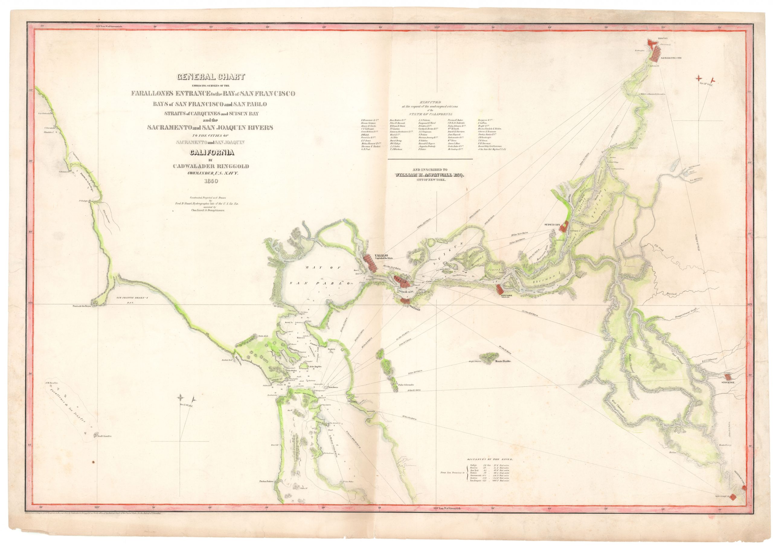
During the late 1840s and 1850s, there were incredible advances in mapping California. Part of this was driven by immigration and growth, and part of it was driven by the expansive ambitions of the United States. Following the Treaty of Guadalupe Hidalgo (1848) and Mexico’s relinquishing of California and other regions to the United States, the Federal government launched a series of initiatives meant to cement this somewhat dubious expansion of US territory. Colonialism had long shown that cartography was an essential part of staking a claim, and by 1850, the California coast had been subject to a number of comprehensive surveying projects.
The English conducted coastal surveys early in the century, the results of which were published by John William Norie in the 1820s (and reissued in 1852). During the 1840s, new surveys were conducted and published, including famous maps by Duflot de Mofras or Cadwalader Ringgold‘s surveys of San Francisco Bay. By the time Baker published this map, there had also been several official American surveys conducted in the region. Examples include the US Coastal Survey and George Horatio Derby’s survey of the coast and hinterland between Santa Barbara and Monterey, both published in 1850 and providing reliable outlines for Baker and other local mapmakers to draw on.
There is, however, more to Baker’s map than simply adopting data from earlier mining maps and coastal surveys, and no place is this reflected better than in Marin County, where Baker provides some interesting details that similar maps of the period did not have. Besides coastal surveys, the only detailed maps of Marin County from the 1840s and 1850s consisted of hand-drawn survey maps delineating specific land grants and the associated ranches. Researchers can inspect a number of such plans through calisphere.org and the Ana T. Kent California Room https://marinlibrary.org/california-room/.
Among the digitized maps are several that refer directly to the Rancho Corte Madera del Presidio. This land grant was granted to John Reed by Mexico in 1834, who logged the area, partly providing timber for building the San Francisco Presidio (Corte Madera means ‘cut wood’ in Spanish). This effort may have included digging out the creek to create an early version of the Corte Madera Canal that connected the interior to the landing point at Larkspur. The area remained largely undeveloped until the 1870s, when it grew into the town still bearing the name today. A significant factor in that development was the railroad construction in 1875. But in 1855, this had yet to happen.
Even so, Baker includes the abbreviated toponym, Corte Madera, on his map. What inspired him to include this and not other land grants is unknown, but as with Sacramento, it may have been due to personal observations and knowledge of the site’s growing importance – especially after the demand for building materials exploded during the Gold Rush. Whatever the case, the inclusion of this specific toponym would be repeated in other important maps of the region long before the town was actually developed.
Van Dorn’s Map of the County of Marin from 1860 (Berkeley call no. G4363.M2 1860 .M3 Case D), for example, lists Corte Madera del Presidio as a private land grant belonging to Reed and even specifies its acreage and includes an at the time nonexistent grid of streets, which it labels Corte Madera. That said, Corte Madera does not figure on the maps of Derby, Ellis, or either of the Jackson states. To establish a more solid terminus post quem, we might return to Ringgold’s iconic 1852 chart of San Pablo Bay, which maps the coastline meticulously and includes numerous toponyms and labels. Yet despite the level of detail, the term Corte Madera does not figure anywhere on this map either.
Therefore, according to our research, the 1855 Baker constitutes the first example of the town’s toponym on a printed map.
Census
The OCLC lists eight institutional copies of this version of the map (no. 25887408). All eight examples are in the United States, and seven out of eight are in California institutions. Yale University Library is the only institution outside California to hold a copy of this important map.
Cartographer(s):
George Holbrook Baker (1827-1906) was a Massachusetts-born artist who learned his trade from the New York engraver George C. Smith. Following his apprenticeship, Baker attended the National Academy of Design before emigrating to California during the height of the Gold Rush. He arrived in San Francisco in late May 1849, and within three months, his first views of the town were being published in New York.
Baker briefly tried his luck prospecting for gold, but like so many other emigrants, he found that it was easier to make a living using the talents and skills with which he arrived. Even today, it is a commonly held notion that the people who became rich from the Gold Rush were the shovel and pan-sellers rather than the prospectors themselves.
In 1852, Baker moved from San Francisco to the new state capital at Sacramento, where he started several businesses and two periodicals while also creating new and sought-after views of northern California. In 1857, Baker drew and published a large birds-eye-view of the young ‘City of the Plain’ (printed as a lithograph by Britton & Rey in San Francisco), which achieved enormous popular success. In 1862, after a devastating flood had ruined him, Baker moved back to San Francisco and started a lithography and publishing firm that specialized in advertising and posters, including architectural and urban vistas, dedicated stock certificates, and regional maps. Despite more than a decade of success, his company was gradually outcompeted during the 1880s, and by around 1890, Baker closed his doors and retired.
Despite his ending in commercial failure, George Baker is acknowledged as one of the most significant artists and lithographers of the Gold Rush era. His work constitutes some of the most important visual documentation of California during the formative decades of its incorporation into the United States.
Condition Description
A few expert repairs to small marginal chips, still fine or nearly so when compared to contemporary lettersheets.
References
Baird, California Pictorial Lettersheets, 145a; Wheat, Maps of the California Gold Region, 273; Wheat Transmississippi 821; Wheat, 25 Significant Maps.