Paolo Forlani’s view of 16th-century Geneva.
Ginevra.
Out of stock
Description
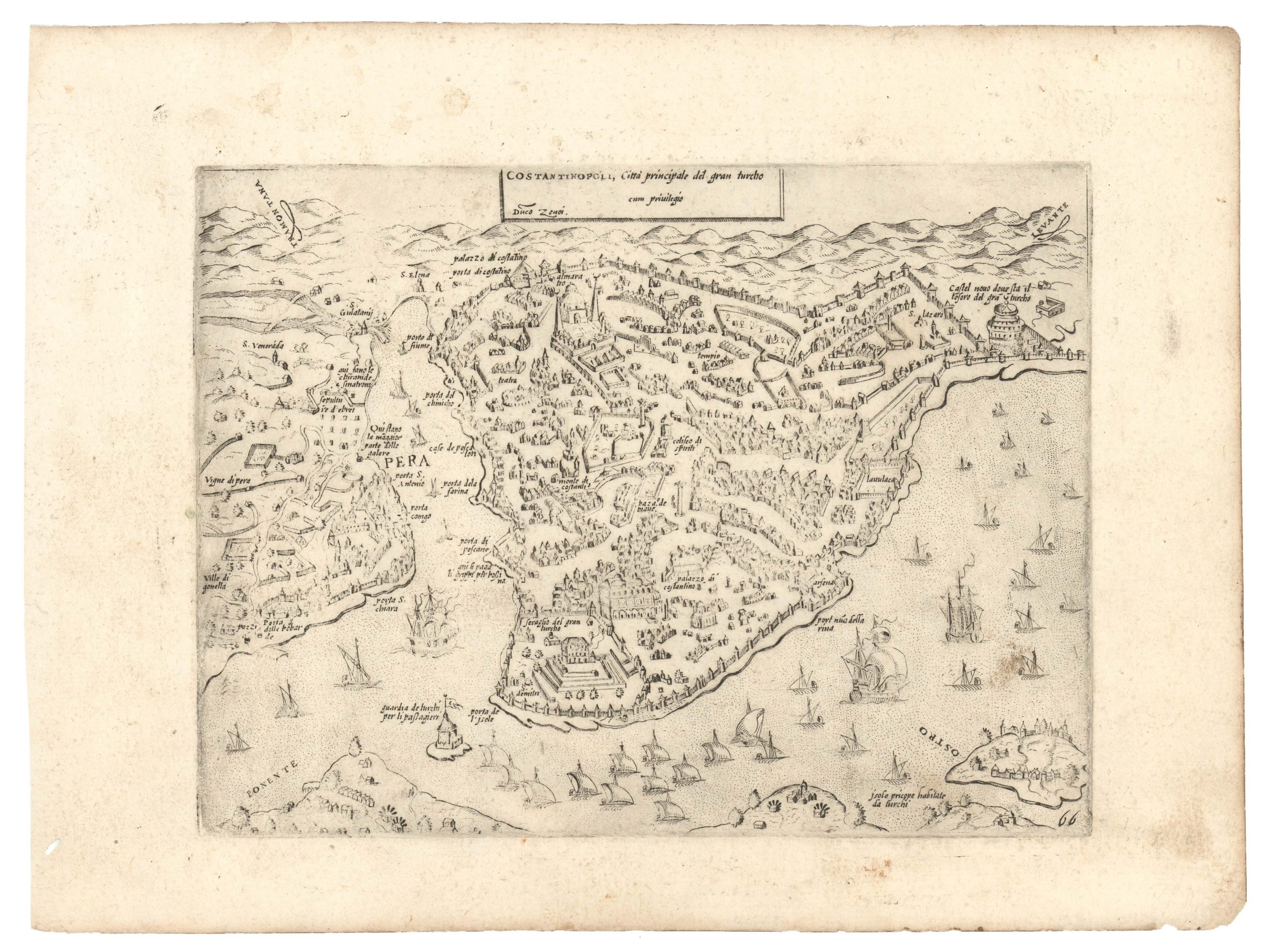
Paolo Forlani’s engraved view of Geneva, dated 1567 and titled Ginevra, constitutes one of the earliest printed prospects of the alpine city, and captures it at the height of its emergence as the principal center of Calvinist Protestantism. Produced in Venice, the print belongs to the corpus of city views associated with the Lafreri school, a loose network of engravers and publishers supplying maps and urban imagery to an expanding market that increasingly included northern Europe. At a moment when Geneva stood as both a sanctuary for Protestant refugees and a flashpoint of confessional conflict, the image offered viewers a rare visual apprehension of a city whose ideological importance far exceeded its modest physical scale.
The engraving’s central emphasis on fortifications and control of waterways presents Geneva not as an open mercantile port, but as a disciplined, defensible republic. Forlani’s composition thus functions simultaneously as a topographical record, a strategic diagram, and a symbolic portrait of a community defined by reform and resistance.
The view is presented from an elevated oblique vantage point south of the city, looking northward across the outflow of Lake Geneva (Lac Léman), where the Rhône emerges and skirts the urban perimeter. The lake occupies the left foreground, its surface rendered by closely spaced horizontal strokes. The Rhône curves along the city’s southern edge before continuing eastward, visually reinforcing Geneva’s defensive reliance on natural barriers. A continuous enceinte of walls encloses the city. Towers punctuate the curtain at regular intervals, some cylindrical, others polygonal, suggesting successive phases of medieval and early modern fortification. Gates are indicated by breaks in the wall aligned with bridges or roads. The overall impression is of a dense defensive ring encircling a tightly packed urban mass.
Within the walls, buildings are drawn in uniform oblique projection, their tiled roofs forming a textured surface from which rise a series of ecclesiastical towers. Most prominent is the monumental Cathedral of Saint-Pierre (A), depicted with twin towers and a long nave dominating the skyline near the city’s highest ground. Other churches are indicated pictorially but not individually named in the legend.
Bridges span the Rhône, linking the districts on either side of the river. A fortified island or midstream structure appears between the bridges, emphasizing control of crossings. A couple of small boats on the lake indicate some commerce despite the militarized setting. Extending along the right riverbank is the so-called Rive Droite, which was connected to the main city (Rive Gauche) by a dam or bridge protected by its own defensive works. Outside the walls lie cultivated fields, roads, and scattered rural buildings. Rolling hills and a winding river valley recede into the background, providing geographic context without distracting from the urban core.
At the upper left is an ornamental cartouche containing the arms of Geneva. The shield is divided vertically into two halves. On the left appears a large key, the traditional attribute of Saint Peter, and a reference to the city’s cathedral chapter of Saint-Pierre. On the right is an eagle, a symbol associated with imperial authority and the city’s historical ties to the Holy Roman Empire. Above the shield, a flowing scroll boasts the city’s Reformation motto: POST TENEBRAS LUX (After darkness, light). Adopted in the sixteenth century, this phrase expresses the Protestant belief that the Gospel had restored true religion after a period of spiritual obscurity.
Along the lower margin, a descriptive paragraph in Italian explains the method of representation and identifies numbered or lettered sites within the image. The text reads:
“Vedendo quanto il mondo sia hoggi di curioso di vedere il sito e forma di Ginevra… ho voluto dunque mandar questa sola amorevolezza che sempre io ho portato a questa terra…”
(Seeing how curious the world today is to know the site and form of Geneva… I have therefore wished to offer this as a token of the affection I have always borne toward this city…)
Following this introduction, the legend enumerates principal locations indicated by letters within the view, including the cathedral of Saint Peter, hospitals, gates, islands, bridges, and religious houses. The list concludes with a publication statement: “In Venetia alla libraria della Colonna l’Anno MDLXVII” (In Venice at the Libreria della Colonna, in the year 1567).
Context is Everything
The engraving was produced only a few years after the death of John Calvin (1564), when Geneva remained the foremost center of Reformed theology under the leadership of Theodore Beza. The city’s political independence and religious orientation placed it in continual tension with the Catholic Duchy of Savoy, which had long sought to reassert control. Fortification and vigilance were therefore a matter of survival, and the prominence given to walls and defensive structures in the engraving reflects contemporary realities rather than purely artistic convention.
Geneva also served as a major refuge for Protestant exiles, particularly from France during the Wars of Religion (beginning in 1562). Its printing presses disseminated vernacular Bibles, theological treatises, and polemical works across Europe, making it a hub of both intellectual and military resistance. For Venetian audiences, reliable visual information about such a strategically important city held obvious value.
The print belongs to the production environment commonly termed the Lafreri school, after the Roman publisher Antonio Lafreri. Rather than a formal institution, this was a commercial network of engravers and booksellers in Rome and Venice who produced maps and city views sold as individual sheets and later assembled into composite atlases. Paolo Forlani was among the most prolific Venetian contributors in the 1560s. Clear linear engraving, balanced compositions, and responsiveness to contemporary geopolitical interests characterize his work.
City views formed a major component of this trade because they appealed simultaneously to practical curiosity and aesthetic appreciation. In an age of expanding travel, diplomacy, and warfare, printed prospects allowed viewers to visualize distant urban environments with unprecedented immediacy.
Publication information & Census
The plate of Ginevra was first issued in 1567 in Il Primo Libro delle città et fortezze principali del mondo, a collection of important urban views attributed to the Lafreri tradition. As with many such works, sheets were marketed individually and could be bound into atlases at the purchaser’s preference, resulting in considerable variation among surviving compilations.
The present state corresponds to the second issue, incorporated into Giulio Ballino’s De’ Disegni delle più illustri città et fortezze del mondo, published in Venice by Bolognino Zaltieri. Ballino’s publication reused existing plates, often without substantial alteration, reflecting common practice in the Venetian print trade, where copper plates were valuable assets circulated among publishers. The identification of states thus commonly relies on factors such as letterpress text, imprint details, paper characteristics, and plate wear. In many cases, the engraved image itself remains unchanged, making contextual evidence essential.
Institutional examples of Forlani’s Ginevra are preserved in major map collections. In the United States, impressions are recorded in the Library of Congress, the Newberry Library in Chicago, and a range of university collections. European holdings include the British Library and the Bibliothèque nationale de France. The wide geographic distribution of surviving copies reflects the print’s appeal across confessional boundaries as a document of geographic and strategic interest.
Cartographer(s):
Paolo Forlani (1525–1581) was an Italian mapmaker primarily active between 1560 and 1571. Born in Venice around 1525, Forlani became one of the most prominent mapmakers of the 16th century. He is particularly noted for his skill in engraving and publishing maps, many of which were produced for inclusion in composite atlases. He collaborated closely with other mapmakers of the time, including Giacomo Gastaldi and Antonio Lafreri, whose works formed the basis of the Lafreri School of Cartography.
During his lifetime and today, Forlani was held in high regard for the quality and detail of his maps, and he played a crucial role in cementing the paradigms of Renaissance cartography.
Condition Description
Excellent condition. Heavy paper, strong print, clean image, wide margins. Verso centerfold reinforced with Japanese tissue paper. Italian text on verso. Some minor spots in outer margins.
References