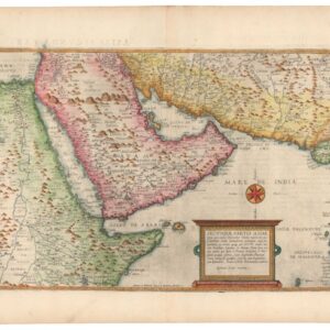
Rare old color Münster Ptolemaic woodcut map of Arabia.
Tabula Asiae VI. [Arabia Felix]
Out of stock
Description
This fine woodcut is an early Ptolemaic map of the Arabian Peninsula presented on a trapezoidal projection with parallels and meridians (the forerunners of lines of longitude and latitude) enumerated in the borders. The sea-bound cartouche includes the names of local tribes, and a fanciful mermaid is shown. This influential map provided the basis on which European cartography depicted the region for nearly a century.
The Arabian Peninsula covers more than 1 million square miles and comprises the modern states of Saudi Arabia, Bahrain, Kuwait, Oman, Qatar, the United Arab Emirates, and Yemen. It is one of the largest regions in the world with no navigable rivers, a circumstance that made exploring and mapping its interior problematic. The first map of the Arabian peninsula to be printed in Europe was in the 1477 edition of Ptolemy. Tibbetts notes that, like other early Greeks, Ptolemy exaggerated the length of Eurasia to the east. The distance between the Red Sea and Persia was too big, and thus Arabia was stretched to fill the gap, mainly because Ptolemy knew the entrance to the Red Sea was very narrow; thus, he had to make the shape fit.
By Ptolemy’s time, Greek sailors had sailed around the Arabian coast and were familiar with port towns. However, its interior remains largely unmapped until the 20th century. The northern part of the peninsula tended to be mapped more accurately because it was closer to populated lands and more frequently traveled, but the interior of Ptolemaic maps are almost entirely fanciful, including the mountain ranges, river systems, and lakes. The cartographic errors are a mix of depicting stories told to sailors about what lies inland and the desire to fill space common in pre-18th century cartography.
There is Latin text on verso.
Cartographer(s):
Sebastian Münster (1488-1552) was a cosmographer and professor of Hebrew who taught at Tübingen, Heidelberg, and Basel. He settled in Basel in 1529 and died there, of the plague, in 1552. Münster was a networking specialist and stood at the center of a large network of scholars from whom he obtained geographic descriptions, maps, and directions.
As a young man, Münster joined the Franciscan order, in which he became a priest. He studied geography at Tübingen, graduating in 1518. Shortly thereafter, he moved to Basel for the first time, where he published a Hebrew grammar, one of the first books in Hebrew published in Germany. In 1521, Münster moved to Heidelberg, where he continued to publish Hebrew texts and the first German books in Aramaic. After converting to Protestantism in 1529, he took over the chair of Hebrew at Basel, where he published his main Hebrew work, a two-volume Old Testament with a Latin translation.
Münster published his first known map, a map of Germany, in 1525. Three years later, he released a treatise on sundials. But it would not be until 1540 that he published his first cartographic tour de force: the Geographia universalis vetus et nova, an updated edition of Ptolemy’s Geography. In addition to the Ptolemaic maps, Münster added 21 modern maps. Among Münster’s innovations was the inclusion of map for each continent, a concept that would influence Abraham Ortelius and other early atlas makers in the decades to come. The Geographia was reprinted in 1542, 1545, and 1552.
Münster’s masterpiece was nevertheless his Cosmographia universalis. First published in 1544, the book was reissued in at least 35 editions by 1628. It was the first German-language description of the world and contained 471 woodcuts and 26 maps over six volumes. The Cosmographia was widely used in the sixteenth and seventeenth centuries and many of its maps were adopted and modified over time, making Münster an influential cornerstone of geographical thought for generations.
Condition Description
Wide margins. Small repair to lower centerfold, and also some small discoloration to centerfold.
References


![[With Extensive Contemporary Annotations] Ordnance Survey of the Peninsula of Sinai Made in 1868-9.](https://neatlinemaps.com/wp-content/uploads/2020/05/NL-00842_Thumbnail-300x300.jpg)
![[With Extensive Contemporary Annotations] Ordnance Survey of the Peninsula of Sinai Made in 1868-9.](https://neatlinemaps.com/wp-content/uploads/2020/05/NL-00842-scaled.jpg)
![[With Extensive Contemporary Annotations] Ordnance Survey of the Peninsula of Sinai Made in 1868-9.](https://neatlinemaps.com/wp-content/uploads/2020/05/NL-00842-scaled-300x300.jpg)
