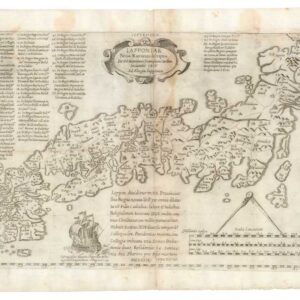
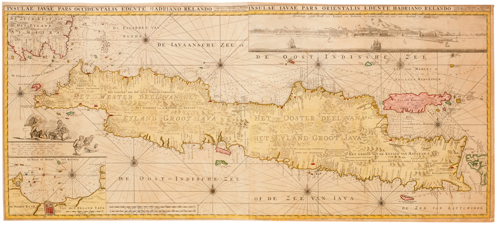
Illustrating a mysterious ancient text: fascinating Ortelius map mixing classical mythology and contemporary exploration.
Erythraei Sive Rubri Maris Periplus, olim ab Arriano descriptus, nunc vero ab Abrah. Orelio ex eodem delineatus
$1,200
1 in stock
Description
This is Abraham Ortelius’s image of classical Asia, centered on the Indian Ocean and depicting East Africa, Arabia, India, and Southeast Asia. It was published in the Parergon, a series of wonderful maps designed to supplement the Theatrum Orbis Terrarum. It illustrates the text of a classical work, Periplus Maris Erythraei, the author of which is uncertain.
The map features three interesting insets. At center is an inset map of Greece and southern Italy that portrays the voyage of Odysseus, with important locations from Homer’s Odyssey, including: Ithaca, Ogygia, Scylla and Charybdis, and the island of the Cyclopes. At upper right is an inset of the Arctic titled Hyperborei. This inset serves the purpose, as Ortelius puts it “for better beautifying or proportioning of this map,” and to remind the reader that in spite of all their exertions, a passage to the Far East via the North Pole has not yet been found by the English or the Dutch.
Cartographica Neerlandica describes the inset map in the top left corner, which represents the Northwest coast of Africa:
King Hanno from Carthago is supposed to be the first who sailed around the continent of Africa to reach the Arabian sea, and incidentally also the first to tame a lion, as related by Plinius, Xenophon and Solinus, who base themselves on Hanno’s writings, as translated by Baptista Ramusio and Conradus Gesnerus.
The map’s presentation of Southeast Asia shows clear ties to the Ptolemaic view of the region, with Sumatra connected to the Golden Chersonese (Malay) by a narrow neck. Why Ortelius has given this region a “classical treatment,” so-to-speak, while Africa, Arabia, and India are all drawn with updated geography is uncertain.
The lines of text placed in Asia read:
“Arrianus, the author of this Periplus [coastal sea journey] is someone who is different from the person who has written about the expedition of Alexander the Great, as it seems to Baptist Ramusio, in his comments on him published in the Italian language because their style of writing is different and dissimilar. He also thinks that he must have lived in the time of Ptolemæus. With which I somehow agree, for he seems to address himself in his Periplus on the Euxine sea to Traianus the emperor. But the other [source] truly seems to be much older, because among others, he cites authors who are hardly more recent than Herodotus and Euripides. Whatever the case may be, the reader will easily gather from the various sources that one of these two from Nearchus at the river Indus navigated to the mouth of the river Tigris, and from that mouth back to the river Indus just mentioned, in fact called the river Sinthum, as you can read on the map, so that everyone understands why the places are named as they are.”
Classical antiquity as visualized by a Renaissance mapmaker – a really interesting map.
Cartographer(s):
Abraham Ortelius (1527-1598) was born in Antwerp to Flemish parents in 1527. After studying Greek, Latin, and mathematics, he and his sister set up shop as book dealers and a ‘painter of maps.’ In his heart, Ortelius was, nevertheless, first and foremost a historian. He believed geography was the ‘eye of history,’ which explains why he collected maps and historical documents with such passion. Ortelius traveled widely in pursuit of his interests, building contacts with mapmakers and literati all over the European continent.
Ortelius reached a turning point in his career in 1564 with the publication of a World Map in eight sheets, of which only a single copy survives. In 1570, he published a comprehensive collection of maps titled Theatrum orbis terrarum (Theatre of the World). The Theatrum is conventionally considered the first modern-style atlas. It was compiled by collecting maps and charts from colleagues across the continent, which Ortelius then had engraved in a uniform size and style. The engraver for most of the maps in Theatrum was none other than the famous Frans Hogenberg, who also served as the main engraver for the 16th-century urban atlas Civitates Orbis Terrarum, published with Georg Braun in 1572.
Hogenberg’s re-drawn and standardized maps formed the basis of the first atlas in history (even though it was Mercator who was the first to use the term a few decades later). Unlike many of his contemporaries, Ortelius noted his sources openly and in the first edition, acknowledged no less than eighty-seven different European cartographers. This ‘catalogus auctorum tabularum geographicum‘ is one of the major innovations of his atlas. The list of contributing mapmakers was kept up-to-date for decades after Ortelius’ death. In the first edition of 1570, this list included 87 names, whereas the posthumous edition of 1603 contained no less than 183 names.
While compiled by Abraham Ortelius in the manner described above, the Theatrum was first printed by Gielis Coppens van Diest, an Antwerp printer experienced with cosmographical books. Van Diest was succeeded by his son Anthonis in 1573, who in turn was followed by Gillis van den Rade, who printed the 1575 edition of Ortelius’ atlas. From 1579, Christoffel Plantin took over, and his successors continued to print Theatrum until Ortelius’ heirs sold the copperplates and the publication rights to Jan Baptist Vrients in 1601. In 1612, shortly after Vrients’s death, the copperplates passed to the Moretus brothers.
Condition Description
Very good.
References
Broecke 224.2; Koeman III, 0500H:31.1.