How the Central Valley became America’s agricultural powerhouse.
San Joaquin, the Gateway County of California
$875
1 in stock
Description
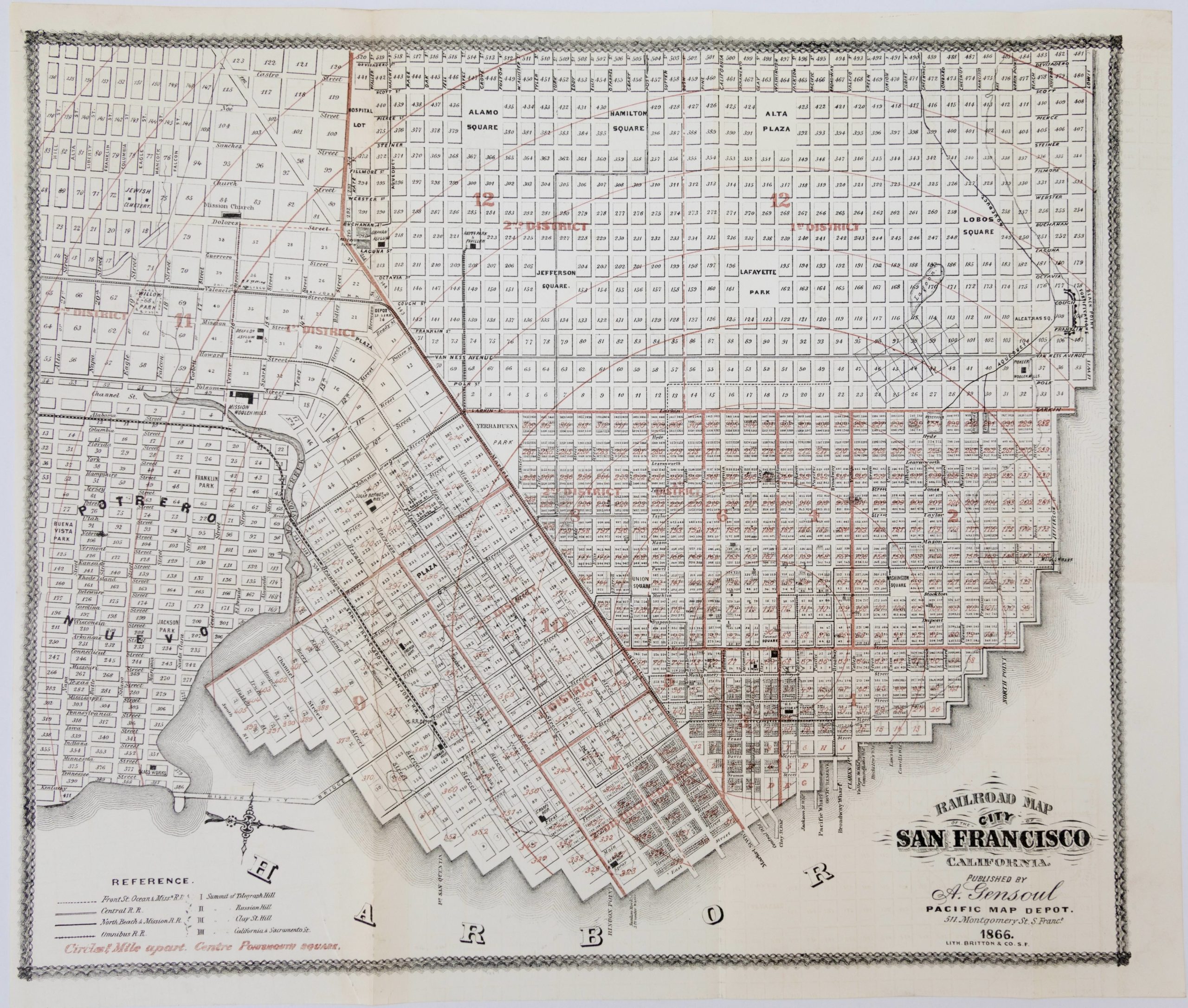
This is a gorgeous 1915 brochure and map advertising San Joaquin County, located to the east of the San Francisco Bay Area in California’s Central Valley. It is an example of California boosterism, specifically designed to attract investors and businesses in agricultural industries to the area. The map includes pictorial depictions of towns and cities, waterways, railways, and roads, as well as indications of the various crops grown throughout the county.
San Joaquin is in many ways the quintessential California county, undergoing several fundamental changes between the early 19th and the early 20th centuries. Like most of California, the Spanish presence in the area was primarily through the Catholic missions, in this case located to the west along the Camino Real. The indigenous Yokuts and Miwok peoples were forced into labor on nearby missions, which provoked a large revolt in the late 1820s led by the remarkable Yokuts leader Estanislao. After Mexican independence, the area was parceled out into massive land grants that were given to rancheros and settlers. With the California Gold Rush, one of these land grants, the Rancho Campo de los Franceses, renamed Stockton in 1849, became a major supply station for miners looking to strike gold in the California Mother Lode to the east. As a result, Stockton developed as an industrial and commercial center and was soon connected by rail to Sacramento and San Francisco.
As the Gold Rush came to an end, San Joaquin County’s flat terrain and ready supply of water made it ideal to support large-scale agriculture. Irrigation (most obvious in the South San Joaquin Irrigation District here) and flood control projects, along with the reclamation of hundreds of thousands of acres of swampland, allowed the Sacramento and San Joaquin Deltas to become some of the most productive agricultural areas in the United States. Stockton became a leader in agricultural machinery, including the Holt Manufacturing Company, the parent company of today’s Caterpillar, Inc., which also was instrumental in the development of tracked military vehicles during World War I (mostly supply vehicles; tanks were sourced from other companies who were no doubt inspired by Holt’s first practicable use of tracked vehicles more than a decade earlier).
Agriculture up and down the Central Valley drastically altered the landscape of San Joaquin County. Although the area shown here generally was flush with water in the rainy season and damming allowed water to be tapped year round, areas further to the south were much drier. A network of hundreds of aqueducts and dams (later expanded considerably under the federal Central Valley Project and the California State Water Project) was built to turn arid land into fertile farms and provide drinking water for the suburban sprawl of Southern California, reducing the San Joaquin River to the point that it was no longer reliably navigable by commercial or passenger vessels. Moreover, the use of turbine pumps to pull out ever more groundwater led to drastic land subsidence, to the tune of 25 feet since the late 19th century, so that much of the delta is now beneath sea level and the area around Stockton is prone to flooding, despite overall drought conditions and the extensive infrastructure built over decades to prevent flooding.
Census
Only two other known examples of this map exist, held by the University of California Davis and the University of the Pacific, respectively.
Cartographer(s):
J.J. Rhea was an American artist, lithographer and mapmaker base din California. He is particularly famous for his early 20th century promotional material for Northern California.
Sierra Art and Engineering Co.Condition Description
Color map printed on cloth-like paper, with color illustrations on side panel and on reverse, plus extensive text. A number of neat, unobtrusive repairs mostly at folds and edges; very good.
References
OCLC lists seven examples as described, and two just describing the map.