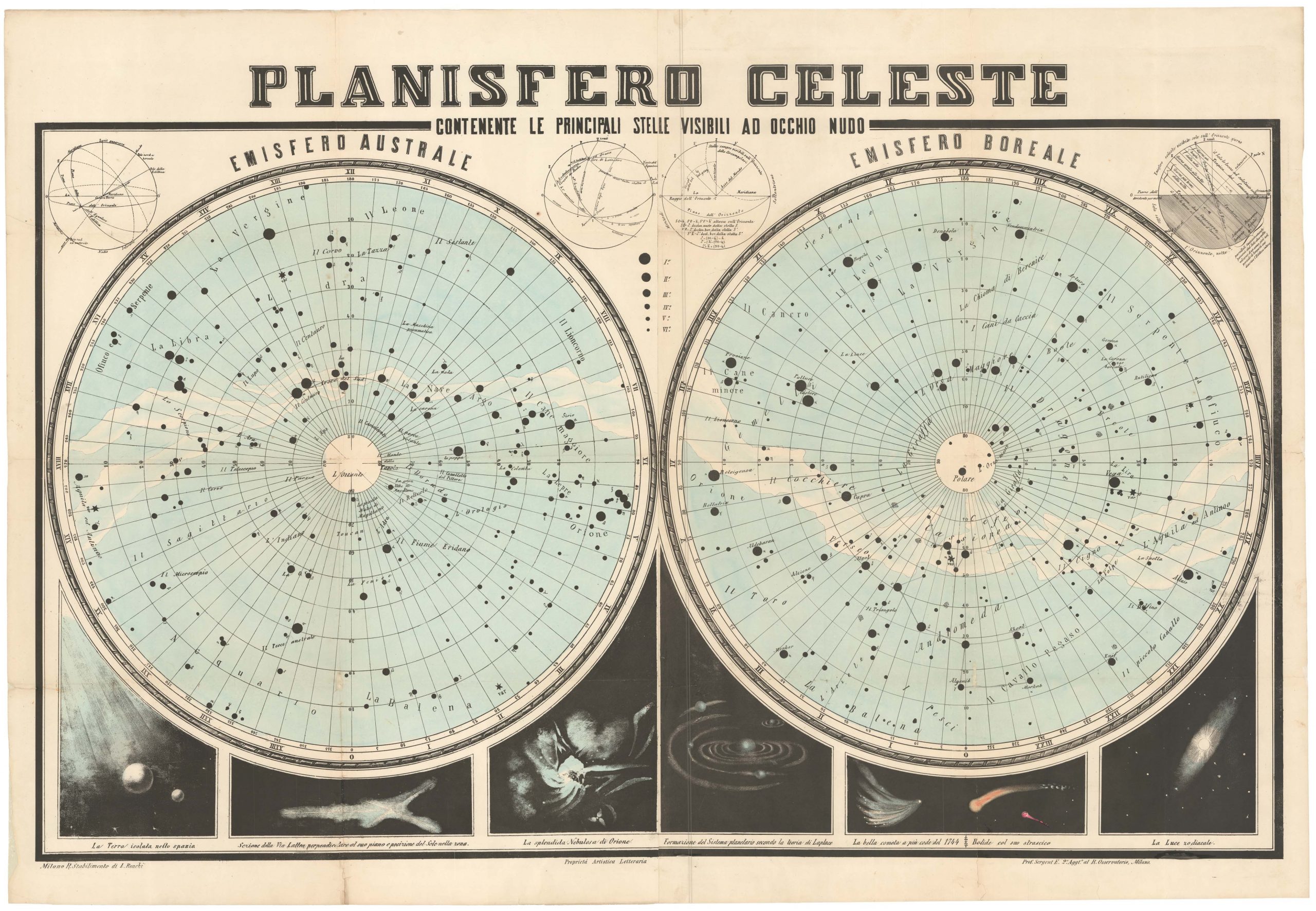
1742 Northern Hemisphere Celestial Chart from Doppelmayr’s Atlas Coelestis.
Globi coelestis in tabulas planas redacti Pars I, in qua longitudines stellarum fixarum… exhibentur.
$1,200
1 in stock
Description
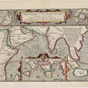
Executed with the meticulousness and dedication of both artist and scientist, this star chart is one of six produced by Johann Gabriele Doppelmayr to depict the heavens as they appeared around 1730. It appeared in the Atlas Coelestis (1742), already in Doppelmayr’s day considered one of the finest astronomical publications on the market, and which was published by Johann Baptist Homann, one of the most important cartographic publishers of the era.
The chart offered here is the first in the set of six, and it depicts the Northern Hemisphere as centered on the equatorial North Pole. Other sheets applied different perspectives, including a view of the Southern Hemisphere as seen from the Antarctic Pole. A significant part of our chart’s appeal is the dramatic visualization of well-known constellations like Cassiopea, Cephus, Ursa Major, Ursa Minor, Draco, Lynx, Auriga, Perseus, Leo Minor, Cygnus, Bootes, Hercules and Lacerta.
Doppelmayr’s charts used a gnomonic projection (with a declination of 45 degrees north), which essentially constitutes an azimuthal projection that takes the center of the earth as its point of perspective. Gnomonic charts are generally non-conformal, meaning that they project great circles as straight lines.
In addition to the illustrated zodiac, Doppelmayr’s chart includes a number of comets and their path. These include astronomical phenomena identified by some of Europe’s most pioneering astronomers like Tycho Brahe (C/1590 E1), Johannes Kepler (C/1618 W1), Giovanni Domenico Cassini (C/1699 D1), and Johannes Hevelius (C/1652 Y1 & 1P/1682 Q1). A particularly charming element in this regard is that one of the Hevelius comets (1P/1682 Q1) is the bolide today known as Halley’s Comet. Along the edges of the chart are panels of explanatory text in Latin, which both identify each of the individual stars visible in this particular portion of the night sky while also providing exact coordinates for their positioning.
Cartographer(s):
Johann Gabriele Doppelmayr was a German mathematician, astronomer, and cartographer. He was born in Nüremberg as the son of a merchant but became something of a polymath by studying at a range of universities throughout Europe. He was widely recognized as an authority during his lifetime, achieving notable positions in the Berlin Academy, The Royal Society, and the Imperial Academy of Sciences and Letters in St. Petersburg.
Throughout most of his professional life, Doppelmayr had a close working relationship with the famous Dominican friar and cartographer Johann Baptist Homann, who among other things published one of his most famous books, the Atlas Coelestis (1742).
Condition Description
Very good.
References
![[LA ROCHELLE] Il vero sito della Rocella hora occupata da heretici et Ribelli di sua Maestà Christianissima della Quale sono Assediati.](https://neatlinemaps.com/wp-content/uploads/2022/11/NL-01639_thumbnail-scaled-300x300.jpg)
![[LA ROCHELLE] Il vero sito della Rocella hora occupata da heretici et Ribelli di sua Maestà Christianissima della Quale sono Assediati.](https://neatlinemaps.com/wp-content/uploads/2022/11/NL-01639_thumbnail-scaled.jpg)