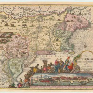
Chatelain’s innovative 1719 chart of North America: a political statement loaded with the latest exciting news from Nouvelle France.
Carte de la Nouvelle France, où se voit le cours des Grandes Rivieres de S. Laurens & de Mississipi…
Out of stock
Description
Striking Original Black-and-White
This magnificent map of the inhabited parts of North America by Henri Abraham Chatelain is one of the most decorative charts of the continent produced in the early 18th century. The map is highly detailed despite covering an enormous area, from Newfoundland and the Hudson Bay in the north to New Spain and the Gulf of Mexico (including parts of Cuba) in the south. In the northeast, we see the regions of Labrador and Newfoundland with a high degree of cartographic information that is maintained as we move down the east coast.
Our map was first issued in Chatelain’s most famous publication, the seven-volume Atlas historique (published 1705-1720). Appearing in volume 6, the map provides an accurate and vivacious view of the North American landmass. Well-known elements such as the Great Lakes and plains are clearly noted and enhanced with extensive notes and observations and a range of little vignettes depicting indigenous peoples, animals, and settlements. In the maritime sphere, we count no less than a dozen sailing ships, a full native canoe, and two sea monsters in the north. Nevertheless, the most impressive features on the map are the St. Lawrence and Mississippi River valleys, which run like spinal columns through the map, just as they did in the French vision of their colonial America. We find this concept echoed in the title of the map, which explicates how the French essentially viewed North America as lands surrounding these two great rivers, of which they were largely in control at this time.
Both the Hudson Strait and Bay are included in the north, yet the map only depicts the eastern half of the Hudson Bay itself, revealing how little explorers knew of this region. The great northwestern frontier is conveniently obscured by a large inset map of the Louisiana coastline, stretching from Florida to the Mississippi Delta. This impressively detailed inset was based on the voyage of Pierre Le Moyne d’Iberville, who in 1699 led an expedition to discover and map the many estuaries of the Louisiana coastline. A similar inset expounding his results was also included on a 1718 map by Nicolas de Fer, which served as Chatelain’s primary source of inspiration. In the lower-left corner of the chart, we find two additional insets, in this case of the French city of Quebec. These have been dramatically enhanced by highly ornamental, almost architectural, cartouches and provide a general view of Quebec – with a key at the bottom identifying important landmarks – and a map of the town and its environs.
Context is Everything
Chatelain published this map in Amsterdam in 1719. That same year, he crafted an even more impressive wall map of the Americas and the Pacific, which still stands as one of the most iconic charts of the 18th century. As a Protestant Huguenot pastor, Chatelain fled to the more tolerant nations of England and the Netherlands instead of his native France. Yet despite his exile and the inclusion of several other European nations’ claims, the map has a distinctly French outlook. Chatelain compiled his map based on earlier large-format maps, which is one of the reasons he was able to fill his more modestly sized map up with so many details. The primary source for Chatelain’s work on this particular map was undoubtedly Nicolas de Fer’s four-sheet map of the inhabited parts of North America, published only a year before this chart.
Framing North America in the way that both de Fer and Chatelain did in their maps was very much in line with French territorial claims and the declared ambition of being the dominant colonial power in North America. While the Dutch and English had fought for decades over the Virginian coastline, the French had established themselves throughout the north and built up the network and infrastructure to develop a flourishing trade. Dominating the North Atlantic trade was the primary motivational factor for establishing a French presence in America. Around 1710 this ambition was further formalized with the creation of the ‘Compagnie Francoise Occident,’ a trading company conceived to sustain the debts of the French King, Louis XIV. As the subtitle of the map informs us, Chatelain compiled this map to promote the company and its agenda. Part of this agenda was the active encouragement of French settlement throughout greater Louisiana, the dual purpose of which was to cement territorial claims and enhance lucrative trade operations.
From a historical point of view, it is nevertheless worth noting that this map was published at roughly the same time that John Law, the renegade Scottish banker involved in setting up the Compagnie financially, established his fiat banking system, which spurred a burst of speculative investments. Eventually, the heavy speculation caused the so-called ‘Mississippi Bubble,’ which constitutes the first financial market collapse in American history.
Cartographer(s):
Henri Abraham Chatelain (1684 – 1743) was a Protestant pastor (Huguenot) from Paris who, due to his faith, was forced to flee his native France. He settled first in London and later in Holland, where he worked from both The Hague and Amsterdam during the early 18th century. While his primary calling was as a preacher, his Atlas Historique became a huge success, partly due to the vivacious decoration and abundance of information on his charts.
Condition Description
Excellent, clean impression. Minor loss along fold line with visible repair.
References
Standard reference: Verner and Stuart-Stubbs #11; Kershaw #332.
