U.S. Army map of the Middle East and Jerusalem meant for soldiers heading from the Persian Gulf Command in Baghdad to Palestine.
So you’re going to Jerusalem!
$475
1 in stock
Description
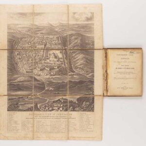
So you’re going to Jerusalem! is a charming little folding map prepared by the U.S. Army during World War II. The map was printed in the U.S. Army weekly, The YANK, and was intended primarily for G.I.s heading from the U.S. Army Headquarters in Baghdad – also known as the Persian Gulf Command or PGC – to Palestine. The folding map, which measures a handy 51 x 34 cm (20 x 13.4 in), was printed on both sides to make the most of its surface. While the main face contains a semi-pictorial map of the whole region, the verso contains two urban plans, a photo of Jerusalem, and a note of advice and context.
Looking at the primary side first, the regional map depicts the land-bound route across the Syrian Desert marked in red. Soldiers would take this exotic route when heading from Baghdad to Palestine. Beneath the map and red line representing the route, we find five imaginary diary entries describing the iconic journey from the port of Basra, at the head of the Persian Gulf, via Central Command in Baghdad, and on to Palestine and Jerusalem. American soldiers stationed in this region would arrive on a carrier vessel at Basra and then take a 17-hour train ride north through some of the most scorching but also most historic territory on the planet (i.e. ancient Sumer and Babylon). The mapmaker portrays the train and its carriages chugging through the ancient landscape.
We note the additional detail of an extensive train line running from Khorramshahr (near Abadan) and Bandar Shapur at the head of the Persian Gulf and extending more than a thousand kilometers north to the capital of Tehran. After the war, especially during the 1950s, Abadan would play a central role in the slow process of widespread radicalization in Iran. Abadan had already become important in the early 20th century when British Petroleum established a major refinery in 1909. It soon became the hub for British petroleum interests in Iran, and the wealth generated by its refinery played a crucial role in the country’s rapid modernization during the 1920s and 1930s. Its nationalization in 1951 led to the Abadan Crisis, which ultimately saw the removal of the democratically elected leader, Mossadegh, by the C.I.A., leading to the so-called Islamic revolution a few decades later.
Sprawled across the top of the map, and obscuring the northern parts of this region, we find a depiction of this same folding map, on which each there is a relevant vignette of soldiers en route to the Holy City, strolling through the streets of Old Jerusalem, or in the Judean Highlands surrounding the city. A similar scene looks like it may be at the beach, probably referring to the twin cities of old Jaffa and new Tel Aviv. On the last page of this depicted folding map, we find the purpose and origin specified: G.I. Road to Jerusalem from P.G.C.
On the verso, we find a range of content, the most central of which are two inserted maps of important Palestinian towns. Both constitute simplified urban plans: one is of Jerusalem, the other of Jaffa and Tel Aviv. On both maps, we find areas hatched in red, indicating zones off-limits to U.S. soldiers after dark (noted on the map as ‘out of bounds’). This included the Old City of Jerusalem and the coastline connecting the twin towns of Tel Aviv and Jaffa. Below the inset plans, we find an area allocated to a given soldier’s personal notes. On the far-right fringe of the verso, we see a cartoon-like image of a soldier on his way to Jerusalem, with the encouraging statement: Going to Jerusalem? Here’s how! Below we find an advertisement for The YANK, or U.S. army weekly, where this map first appeared.
A final note should be made on an inserted photograph of the Holy City taken from the Mount of Olives. This classical view of Jerusalem remains one of the most poignant to this day and reflects the deep spiritual meaning that an R&R trip to Jerusalem might have had for many of the American G.I.s. Above the photograph is the publication’s main text, which not only specifies the map’s purpose but also includes an introductory text to Tel Aviv, which is described as ‘…the most modern city in the world’ and ‘….the nearest thing to the States on this side of the ocean’.
Cartographer(s):
Yank, the Army Weekly was a weekly magazine published by the United States Army Persian Gulf Command during World War II. The Persian Gulf Command was the United States Army’s service command point in the Middle East during World War II. It was established already in 1941 when the U.S. Army Corps of Engineers established the U.S. Military Iranian Mission. The following year, it was converted to the Persian Gulf Service Command, and in December 1943 became the Persian Gulf Command.
The purpose of the command was to facilitate the supply of U.S. lend-lease war material to the Soviet Union through the so-called ‘Persian Corridor.’ Controlling the Gulf was of extreme importance to the different warring parties. The British and Russians had established oil infrastructure before the War, but Hitler believed that the German Army would be able to take control of these vital resources following a successful invasion of Russia. As we all know, the Russian campaign did not fare as Hitler had imagined, and once the Americans established a military presence in the Gulf, there was no longer any realistic scenario in which the oil and petroleum resources would fall into German hands.
Condition Description
Folding map. Good condition, creases, wear.
References