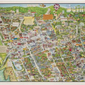
Beloved cartoonist Fred R. Lundy’s scarce 1934 pictorial map of Berkeley and Oakland.
Cartographer’s Impressions of Early Days in Eastbay
Out of stock
Description
Fred Lundy was celebrated for his humorist cartography, which blended satirical cartoons and the genre of pictorial mapmaking. This scarce bird’s-eye-view of the San Francisco Bay Area was published through the Oakland Tribune, where Lundy worked as the staff cartoonist. It was also printed in a reduced version, but our example is the original larger edition. It contains the title bar at the top and constitutes a crisp and clear printing, professionally laid on poster linen for preservation and display.
Lundy sets the view from an imaginary point high above the Oakland Hills. The perspective looks to the east across the Bay and the city of San Francisco. As the title suggests, the most dominant feature is a panoptic view of the region’s history. Images and their associated text boxes cover everything from the initial arrival of Europeans, across the many significant technological advancements, to quirky historical details such as the depiction of the wood-built bull ring in Oakland, where bullfights were held every Sunday until 1854.
The map combines aspects of more traditional pictorial maps of California with the emerging humorist or satirist approaches to pictorial cartography, notable regional examples being the maps of Jo Mora or Harrison Godwin’s map of San Francisco. Historian Frank Kester supplied concrete historical narratives and witty observations in text boxes to accompany Lundy’s illustrations. Other pictorial elements subtly celebrate historical peoples, events, or phenomena. There is, however, a quiet and somewhat marginalized presence of Native Americans on the map. They are there throughout, but it is as if they are the only figures not cloaked in humor.
Overall, this charming pictorial map brings to life part of the complex history of the Bay Area. It does so lovingly and intends to provide a balanced historical overview laced with humor and satire. It is a gem for any collection focusing on the mapping of San Francisco and the Bay Area in the 20th century.
Census
As this map was originally conceived for and printed as part of a newspaper, it is difficult to ascertain the number of copies made. We find examples in the David Rumsey Collection (List no. 8549.000) and the holdings of the Oakland Museum of California (No. 2004.7.1). In addition to these, the University of California’s library at Berkeley holds an extensive archive of Fred R Lundy’s original drawings and cartoons (OCLC no. 728311293 & 953126950), which likely includes this map as well.
Cartographer(s):
Fred R. Lundy (1902-1989) was born in North Dakota at the turn of the 20th century. He studied at the University of Oregon and the California College of Arts and Crafts and later worked as a staff cartoonist for the Oakland Tribune (1928-1935). In 1935, Lundy became an editorial cartoonist for the San Francisco Examiner, where he remained until his retirement in 1976. In addition to the two newspapers that employed him, Lundy’s work was also published in magazines like The New Yorker, Colliers, Esquire, Saturday Evening Post, Argosy, Saturday Review, Redbook, Liberty, and American Magazine.
Fred Lundy died in 1989.
Condition Description
Excellent. Professionally laid on poster linen.
References
