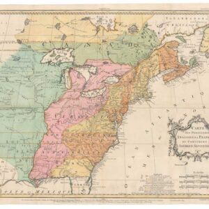
Superlative old color example of Blaeu’s famous map of the Americas.
Americae Nova Tabula.
Out of stock
Description
Fine contemporary color.
Among the most significant maps of the Golden Age of Dutch cartography.
An obligatory cornerstone of any collection of the New World.
Willem Blaeu’s map of the Americas is one of the most attractive maps produced during the 17th century, the so-called Golden Age of Dutch cartography. Blaeu produced a range of seminal maps and atlases that continue to garner interest among collectors and institutions alike. Within this enormous output, Blaeu compiled only a few maps focussing on the Americas, making these some of the most sought-after maps of the era.
The map depicts both continents in their full outline, although the Northwest Pacific remains obscured a lack of exploration. Among the features that made Blaeu’s map stand out from its peers was the choice to surround the map with vignette borders along the top and sides. The row at the top consists of nine town views, depicting the most important cities in the New World (Havana, St Domingo, Cartagena, Mexico City, Cusco, Potosi, La Mocha, Rio de Janeiro, and Olinda in Pernambuco). All the cities are to be found either in South or Central America or the Caribbean. During this early phase of colonial history, there has yet to be any European settlement north of the 23rd parallel (i.e. Havana and Mexico City) that merited inclusion on Blaeu’s map.
Along either flank of the map, we find five vignettes depicting some of the peoples of America in what was perceived as traditional garb. This group is far more diversified than the selection of cities represented. In the upper left corner, we find Greenlandic Inuit, for example, but also depictions of North American indigenous peoples from places such as Virginia and Florida. There is even a depiction of indigenous Californians, labeled here with the term given to this region by Sir Francis Drake (Nova Albioni). Phillip Burden has pointed out that in designing this vignette frame, Blaeu, in all likelihood, borrowed both ideas and specific elements from Theodore de Bry.
The map itself is as fantastic as its framing vignettes. The style is, in many ways, transitional, reflecting how Willem Blaeu pushed new paradigms to the forefront of mapmaking. Many early Dutch cartographers such as Jan Huygens van Linschoten, Theodor de Bry, or Cornelis Claesz represent a style of mapmaking that, by the middle of the 17th century, had changed considerably. In this map, we are witnessing this transition of style and purpose firsthand. While the outline of the continents is stringent and rendered according to the latest observations and surveys, the decorative elements associated with Dutch mapmaking remain in full flourish. Thus we find the maritime spaces brimming with ferocious sea monsters and proud vessels of exploration and trade. Nevertheless, interspersed between these characteristically 16th-century elements, Blaeu expends enormous effort to depict and position islands and archipelagos just right.
The unknown West Coast
Among the many features that set Blaeu’s chart apart from his peers is the rendition of the still obscure west coast of the North American continent. Sure, a number of explorers had sailed on these regions, but the reports differed dramatically. They were often embedded with ambitions related to the global political climate rather than accurate surveying. At this stage, vast parts of North America – including California – still belonged to New Spain. Both the English and the Dutch had fought to rid themselves of Spanish influence at home, partly by shedding the Catholic Church. There was, in other words, a natural affinity between the Dutch and English, while access to Spanish sources on the region remained challenging to acquire.
Among this map’s unusual features is that California is represented in its correct peninsular form rather than as an island. This would otherwise become the dominant trend over the next century or so. The Gulf of California also retains its old name, Mar Velmelo or Red Sea, which goes back to the explorations of Francisco Ulloa. In 1539, Ulloa was the first European to sail north along Mexico’s Pacific coast until reaching the head of the Gulf. He described the waters here as distinctly red, presumably the result of a geological discharge into the water. While the peninsula model was used widely in the 16th and early 17th century (e.g. Wytfliet), towards the end of the century, the notion of an island had taken a firm hold with most European cartographers (e.g. Doncker).
Beyond California, the Northwestern coastline of America appears to continue north as a solid mass. From the toponyms included on the map, we can nevertheless ascertain that Blaeu is playing a trick. The northernmost location Blaeu depicts on the West Coast of America is Cape Mendocino, just north of San Francisco. This composition is brilliant, as it stretches the known parts of the west coast so far north that it appears as if Blaeu is providing a map of the great unknown. Yet the modern observer will note that the positioning of Cape Mendocino on the west coast corresponds to the northern part of the Davis Strait on the more well-documented East Coast, in effect eschewing the entire continent’s geography to make his map coherent and attractive.
The reality was that the geography of the Pacific Northwest remained unexplored when this map was first published in 1617. It would take another hundred and eleven years (1728) before the Danish explorer Vitus Bering properly surveyed the strait between Asia and America on behalf of the Russian Tzar.
Concluding thoughts
The map is filled with countless fascinating details, many corresponding to myths and legends rather than observed facts, drastically expanding the geographic understanding of the Americas back in Europe. Blaeu’s work set a standard by which both his contemporaries and his successors were measured. The quality of the engraving, the paper, the coloring used, and indeed of the geography itself was consistently done according to the highest standards of the time. John Goss, a renowned cartographic scholar and author of the book The mapping of North America (1991; no. 26), clearly holds Blaeu’s map in the highest regard when he states: “this magnificent map sums up the general European view of the western hemisphere in the early seventeenth century…“
Census and publication history
Willem Blaeu’s hugely influential map of the Americas was published in five distinct states, of which only the latest three can still be obtained. Neatline’s example is the fourth state, published in 1642. Burden has identified the five states by the following features:
State 1 (1617): There is no Le Maire Strait; Auct: Guiiljel: Janssonio in cartouche.
State 2 (1618): New islands have been added in the South Pacific, just as the Le Maire Strait has been added. Tierra del Fuego is now shown as an island.
State 3 (1621): Name of author revised to Guiljelmo: Blaeuw
State 4 (1642): New engravings to increase the seascape’s decorative element. The most notable of these is the addition of surface features in the graticule square above the word “Capricorni,” left of the sailing ship.
State 5 (1645): Further extensions of the engraved areas. Large swathes of coarse cross-hatching have reduced the more natural wavy quality of earlier states.
Because of Blaeu’s enormous popularity during his lifetime and the many translations and editions of his atlases, defining the exact number of institutional copies is almost impossible. We have ascertained that at least six institutional libraries hold the 4th State that Neatline is offering. These include the University of Bern, Erfurt, and Ingolstadt, the Staatliche Bibliothek in Regensburg, the Staatliches Landesbibliothenk in Dresden, and the Ibero-Amerikanisches Institut in Berlin (no. 605370897). An additional 18 editions are listed at 55 different institutional libraries worldwide (no. 756413165).
On the private market, we note a few examples for sale. Most of these are the last (and aesthetically least pleasing) state from 1645. Copies of the earliest obtainable state (3) occasionally surface, but these are consistently priced much higher than Neatline’s gorgeous example.
Cartographer(s):
Willem Janszoon Blaeu (1571-1638) was one of the most important Dutch geographers and mapmakers of the 17th century. He was born the son of a herring merchant but traded fishmongering for studies in mathematics and astronomy. Blaeu’s first important breakthrough was winning an apprenticeship with the famous Danish astronomer Tycho Brahe. Working at Brahe’s Uranienborg observatory on the island of Hven, Blaeu learned various disciplines and technical skills. These included mathematics, astronomy, instrument-making, and more esoteric disciplines such as alchemy. Returning to his native Holland, Blaeu established a publishing business in Amsterdam. He sold instruments and globes, printed maps, and his own editions of some of the great philosophical works of contemporary intellectuals like Descartes and Hugo Grotius. Achieving notoriety as a cartographic pioneer, Blaeu was appointed Chief Hydrographer to the powerful Dutch East India Company, a position he held until he died in 1638.
When Willem died, his sons Cornelis (1610-1648) and Joan (1596-1673) took over the business. Joan had originally trained as a lawyer but never took up the practice, preferring to work on maps with his father. After Willem’s death, Joan continued publishing his father’s and his own maps. He also assumed his father’s position as a hydrographer for the Dutch East India Company. Towards the end of his life, Joan would dramatically expand his father’s Atlas Novus (1635), turning it into his own masterpiece, the Atlas Maior (1662-72).
When Willem died, his two sons Cornelis (1610-1648) and Joan (1596-1673) took over the business. Joan had originally trained as a lawyer, but never took up practice, preferring to work on maps with his father. After Willem’s death, Joan continued to publish both his father’s and his own maps. He also assumed his father’s position as hydrographer for the Dutch East India Company. Towards the end of his life, Joan would dramatically expand his father’s Atlas Novus (1635), turning it into his own masterpiece, the Atlas Maior (1662-72).
Condition Description
Original color. Very good. Some toning along the edge and along the centerfold in the margins. Repair to centerfold in margins. Printed text in Dutch on verso. Fourth state with name as 'Guiljelmo Blaeuw' and new detail in the sea above the word "Capricorn" (Tropicus Capricorn), to the left of the sailing ship.
References
Burden 189; Goss 26; Tooley, America, pp. 296-97.