Mapping the Outside Lands – a foundational map for the history of San Francisco.
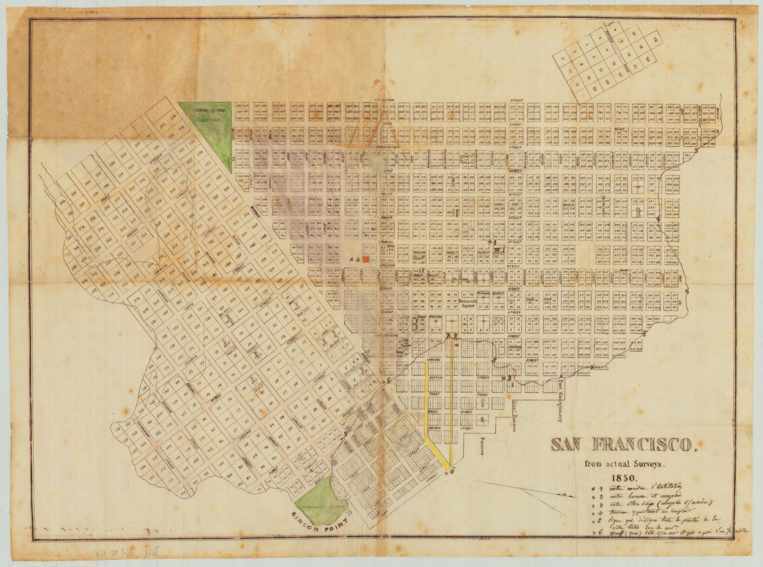
Map of the Outside Lands of the City and County of San Francisco Showing Reservations Selected for Public Purposes, under the Provisions of Order No. 800
$2,400
1 in stock
Description
This map is a critical document for San Francisco’s history and urban development. It was created just after the lands outside the 1851 Charter line were turned over to the city of San Francisco following years of legal disputes.
For a more detailed look, please see our video essay on a previous uncolored version of the map: https://youtu.be/YCeDvWK5CCk
Today we think of the “Outside Lands” as the part of the city west of the dividing line at Divisadero St. (hence the name); namely, what is now the Richmond and Sunset, Golden Gate Park, and smaller adjacent neighborhoods. But it is interesting to note an area on the southeast of the map comprising part of Potrero Hill that is also designated as “outside.”
From 1852 to 1866, the west side was the focus of two intense legal battles fought in parallel: a fight over whether the land belonged to the U.S. government or the City of San Francisco and a struggle over individual ownership of land plots at the private level. The critical point of these battles was that this land was ceded as part of the conclusion of the Mexican-American War by Mexico, not to California (which wasn’t yet a state), but to the U.S. federal government.
The Outside Lands Act of 1866 ruled in favor of the city, confirming that this land was part of San Francisco. This ruling set the stage for Order no. 800, mentioned in the title of our map, in which the board of supervisors decided the legal implications of the Outside Lands Act.
The map identifies the following members of the Committee — each with a street named after them: Chas. H. Stanyan, A.J. Shrader, Beverly Cole, Chas. Clayton, and Monroe Ashbury.
The mapmakers located Golden Gate Park and Buena Vista Park but labeled them only Park. Two unlabeled lines, one dotted and one solid, run irregularly through the Sunset District; the former represents a line of sand drift, and the latter traces the Spring Valley Flume from San Mateo County.
Cartographer(s):
Britton & Rey (1852 – 1906) was a lithographic printing firm based in San Francisco and founded by Joseph Britton and Jacques Joseph Rey in 1852. Especially during the second half of the 19th century, Britton and Rey became the leading lithography firm in San Francisco, and probably California. Among their many publications were birds-eye-views of Californian cities, depictions of the exquisite landscapes, stock certificates, and no least maps. While Rey was the primary artist, Britton worked not only as the main lithographer but was essentially also the man running the business. In addition to their own material, the firm reproduced the works of other American artists like Thomas Almond Ayres (1816 – 1858), George Holbrook Baker (1824 – 1906), Charles Christian Nahl (1818 – 1878), and Frederick August Wenderoth (1819 – 1884). Following Rey’s death in 1892 Britton passed the form on to Rey’s son, Valentine J. A. Rey, who ran it until the great earthquake and fire of 1906 destroyed most of the company’s assets.
Joseph Britton (1825 – July 18, 1901) was a lithographer and the co-founder of the prominent San Francisco lithography studio Britton and Rey. He was also a civic leader in San Francisco, serving on the Board of Supervisors and helping to draft a new city charter. In 1852, he became active in lithography and publishing, first under the name ‘Pollard and Britton,’ and then ‘Britton and Rey,’ a printing company founded with his friend and eventual brother-in-law Jacques Joseph Rey. Britton and Rey became the premier lithographic and engraving studio of the Gold Rush era, producing letter sheets, maps, and artistic prints.
Jacques Joseph Rey (1820 – 1892) was a French engraver and lithographer born in the Alsatian town of Bouxwiller. At the age of about 30, he emigrated to America, eventually settling in California. Here, he soon entered into a partnership with local entrepreneur and civic leader Joseph Britton. Three years later, Rey also married Britton’s sister, allowing his business partner and brother-in-law Britton to live in their house with them. Rey and Britton were not only an important part of the San Francisco printing and publishing scene but also owned a plumbing and gas-fitting firm. In the early years, both men would sometimes partner up with others on specific projects, but by the late 1860s, their partnership was more or less exclusive.
Committee on Outside Lands of Board of SupervisorsCondition Description
Linen-backed. Excellent.
![5-sheet set showing San Francisco’s post-1906 earthquake water supply [SF’s first fireboat!]](https://neatlinemaps.com/wp-content/uploads/2022/03/NL-01375-sheet-4_thumbnail-scaled-300x300.jpg)
![5-sheet set showing San Francisco's post-1906 earthquake water supply [SF's first fireboat!]](https://neatlinemaps.com/wp-content/uploads/2022/03/NL-01375-sheet-4_thumbnail-scaled.jpg)

![[1906 EARTHQUAKE PANORAMA – FINANCIAL DISTRICT]](https://neatlinemaps.com/wp-content/uploads/2020/10/Screen-Shot-2023-02-06-at-6.55.56-PM-300x300.png)