Britton & Rey (1852 – 1906) was a lithographic printing firm based in San Francisco and founded by Joseph Britton and Jacques Joseph Rey in 1852. Especially during the second half of the 19th century, Britton and Rey became the leading lithography firm in San Francisco, and probably California. Among their many publications were birds-eye-views of Californian cities, depictions of the exquisite landscapes, stock certificates, and no least maps. While Rey was the primary artist, Britton worked not only as the main lithographer but was essentially also the man running the business. In addition to their own material, the firm reproduced the works of other American artists like Thomas Almond Ayres (1816 – 1858), George Holbrook Baker (1824 – 1906), Charles Christian Nahl (1818 – 1878), and Frederick August Wenderoth (1819 – 1884). Following Rey’s death in 1892 Britton passed the form on to Rey’s son, Valentine J. A. Rey, who ran it until the great earthquake and fire of 1906 destroyed most of the company’s assets.
Joseph Britton (1825 – July 18, 1901) was a lithographer and the co-founder of the prominent San Francisco lithography studio Britton and Rey. He was also a civic leader in San Francisco, serving on the Board of Supervisors and helping to draft a new city charter. In 1852, he became active in lithography and publishing, first under the name ‘Pollard and Britton,’ and then ‘Britton and Rey,’ a printing company founded with his friend and eventual brother-in-law Jacques Joseph Rey. Britton and Rey became the premier lithographic and engraving studio of the Gold Rush era, producing letter sheets, maps, and artistic prints.
Jacques Joseph Rey (1820 – 1892) was a French engraver and lithographer born in the Alsatian town of Bouxwiller. At the age of about 30, he emigrated to America, eventually settling in California. Here, he soon entered into a partnership with local entrepreneur and civic leader Joseph Britton. Three years later, Rey also married Britton’s sister, allowing his business partner and brother-in-law Britton to live in their house with them. Rey and Britton were not only an important part of the San Francisco printing and publishing scene but also owned a plumbing and gas-fitting firm. In the early years, both men would sometimes partner up with others on specific projects, but by the late 1860s, their partnership was more or less exclusive.
-
-
Add to cart
 Quick View
 - California
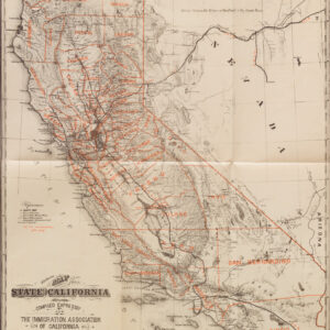
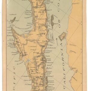
Californien. Veröffentlicht von der Einwanderungs-gesellschaft von Californien. (“The Immigration Association of California.”) San Francisco. No. 10 California Str. (wrapper title)
- $275
- Britton & Rey 1882 California guide for German immigrants, with Lake Tahoe as 'Bigler Lake.'
-
-
-
-
Add to cart
 Quick View
 - Bay Area & Silicon Valley, California
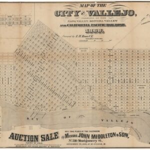
Map of the City of Vallejo, terminus of the Napa Valley, Sonoma Valley and California Pacific Railroad.
- $4,500
- The first official town plan of Vallejo.
-
-
-
-
Add to cart
 Quick View
 - California
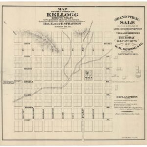
Map of the Town of Kellogg. Knight’s Valley. Napa & Sonoma Counties, California.
- $725
- A scarce 1875 Britton & Rey lot sale map of Kellogg, California.
-
-
-
-
Add to cart
 Quick View
 - California, San Francisco
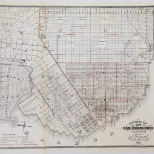
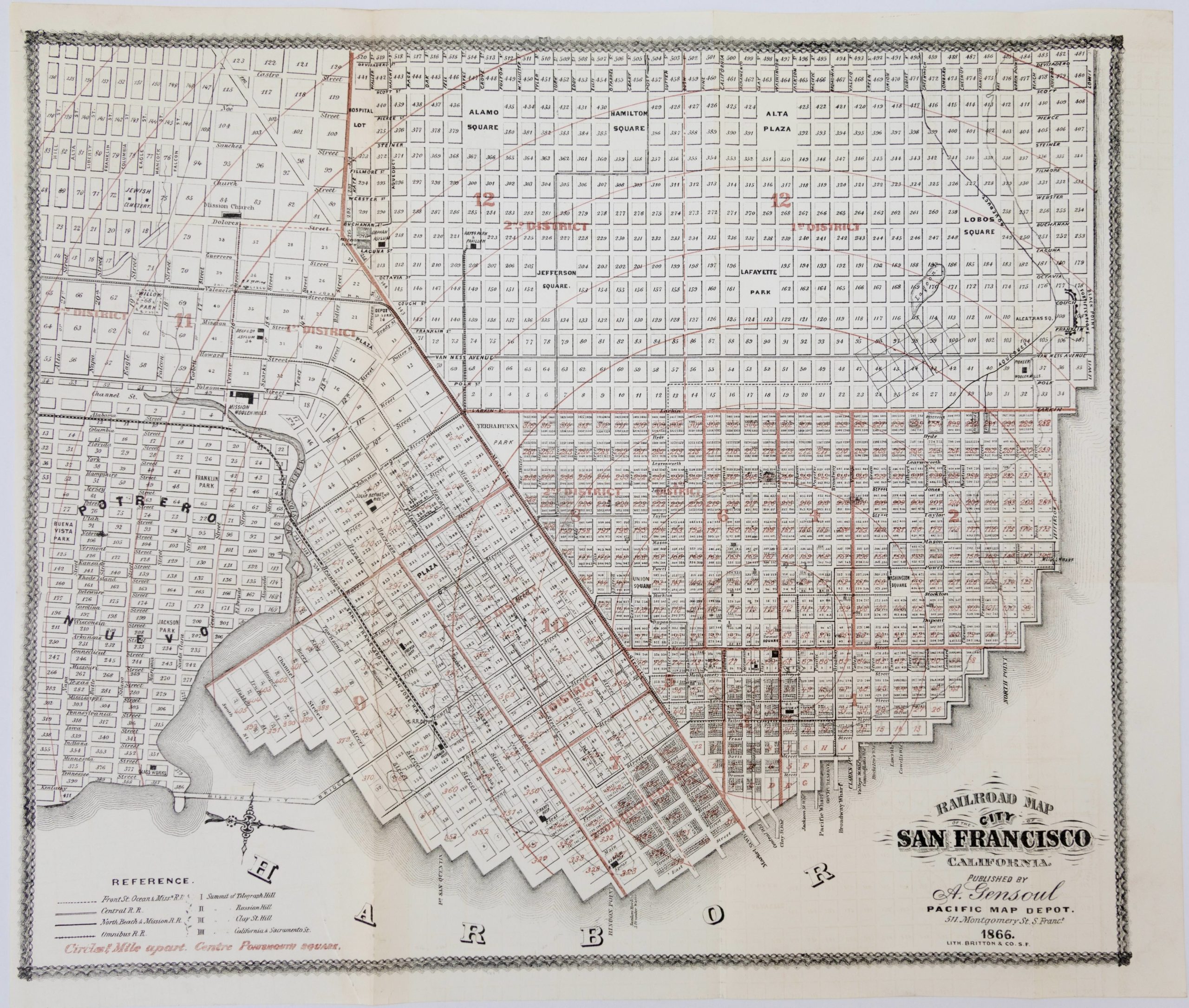
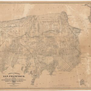
Railroad Map of the City of San Francisco California
- $650
- Documenting a rapidly expanding city: 1866 map of San Francisco.
-
-
-
-
-
Add to cart
 Quick View
 - Atlases & Books, California, San Francisco
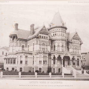
Artistic Homes of California.
- $9,500
- The most extensive collection of pre-1906 Bay Area architectural masterpieces.
-
-
-
-
Add to cart
 Quick View
 - San Francisco
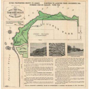
Map of the Ocean Shore Lands. Sutro Baths & Museum Sutro Heights.
- $875
- A large Britton & Rey cartographic advertisement for Sutro’s shore-lands.
-
-
-
-
Add to cart
 Quick View
 - San Francisco
Official Map Of The City Of San Francisco, California. Published by Josiah J. LeCount…Approved By Geo. R. Turner City & County Surveyor
- $12,500
- The definitive Silver Rush plan of a new and expanded San Francisco.
-
-
-
-
Add to cart
 Quick View
 - Bay Area & Silicon Valley, California
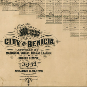
Map of the City of Benicia Founded By Mariano G. Vallejo, Thomas O. Larking & Robert Semple 1847 Surveyed & Drawn By Benjamin Barlow City & County Surveyor.
- $6,500
- Barlow’s rare and pioneering map of Benicia - the earliest comprehensive plan of one of California’s first state capitals.
-
-
-
-
Add to cart
 Quick View
 - Bay Area & Silicon Valley, Bird's-eye-views, California
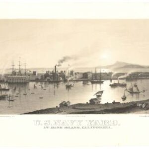
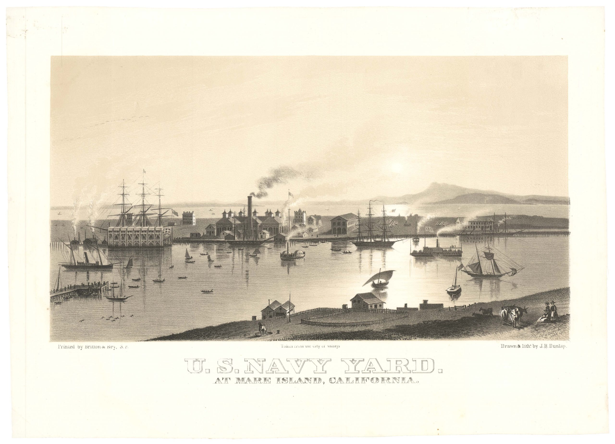
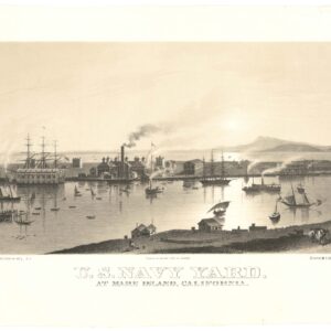
U.S. Navy Yard. At Mare Island, California.
- $4,500
- Early view of the U.S. Navy Yard at Mare Island, with Marin and Mount Tamalpais in the background.
-
-
-
-
-
Add to cart
 Quick View
 - California, San Francisco
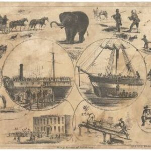
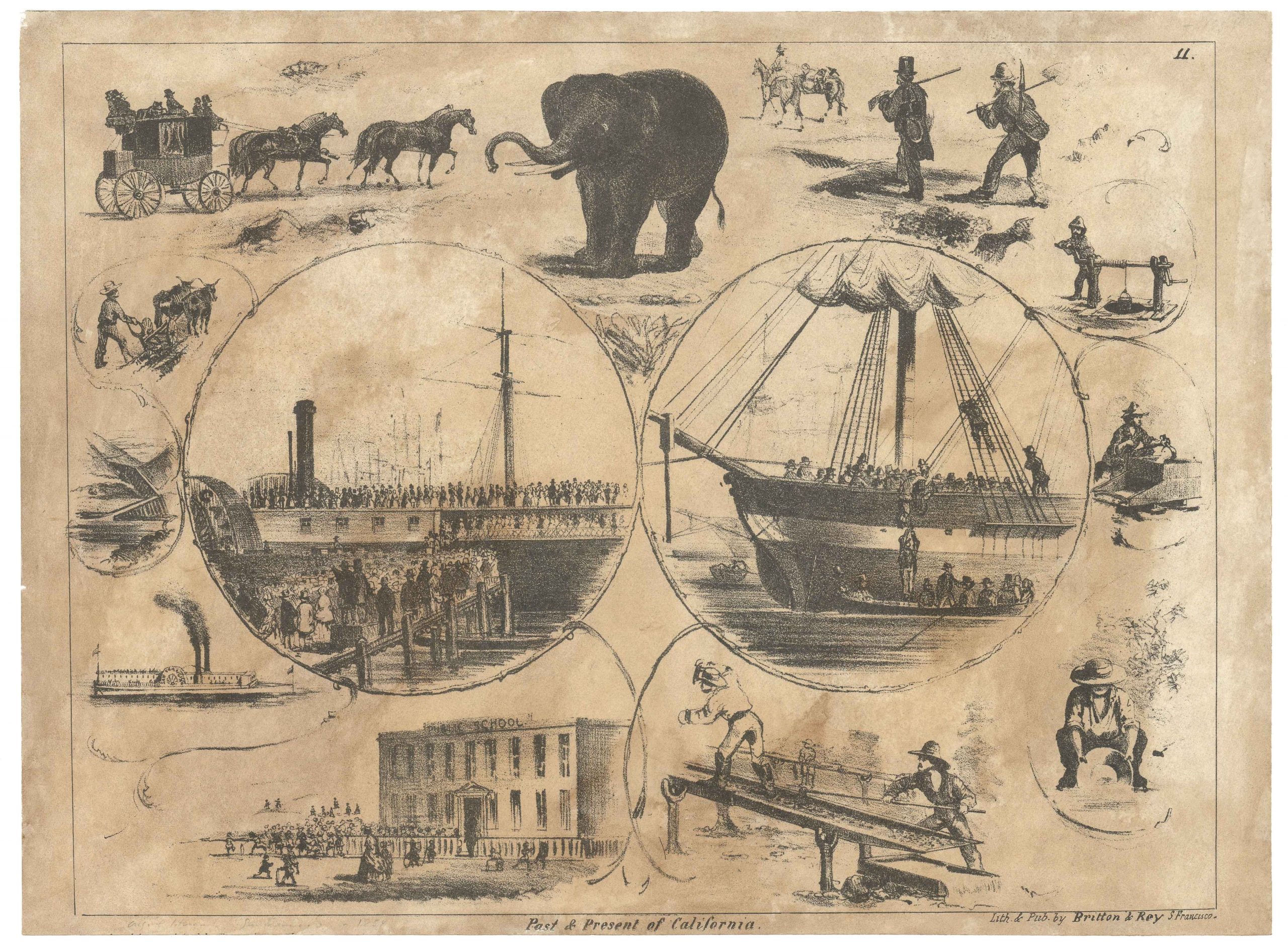
Past & Present of California.
- $975
- The elusive ‘Elephant’ pictorial letter sheet of life in California.
-
-
-
-
-
Add to cart
 Quick View
 - San Francisco
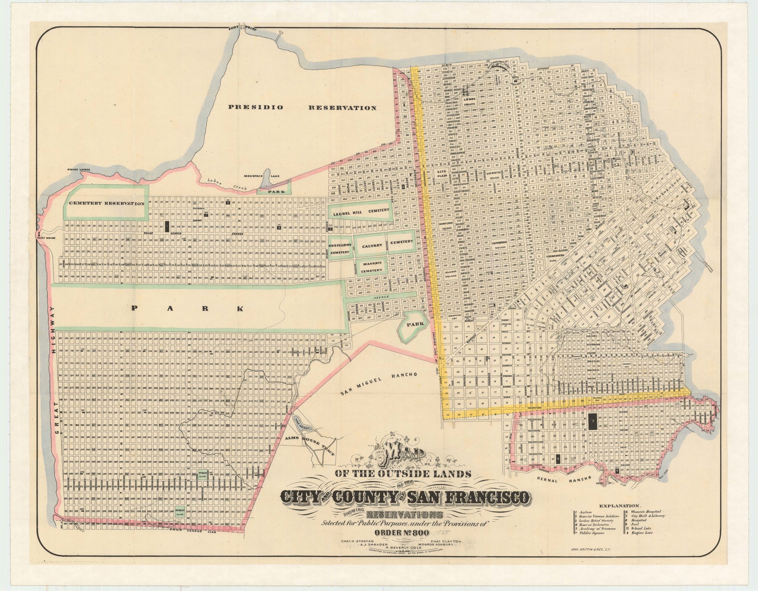
Map of the Outside Lands of the City and County of San Francisco Showing Reservations Selected for Public Purposes, under the Provisions of Order No. 800
- $2,400
- Mapping the Outside Lands - a foundational map for the history of San Francisco.
-
-
-
-
-
Add to cart
![5-sheet set showing San Francisco’s post-1906 earthquake water supply [SF’s first fireboat!]](https://neatlinemaps.com/wp-content/uploads/2022/03/NL-01375-sheet-4_thumbnail-scaled-300x300.jpg)
![5-sheet set showing San Francisco's post-1906 earthquake water supply [SF's first fireboat!]](https://neatlinemaps.com/wp-content/uploads/2022/03/NL-01375-sheet-4_thumbnail-scaled.jpg) Quick View
Quick View - San Francisco
5-sheet set showing San Francisco’s post-1906 earthquake water supply [SF’s first fireboat!]
- $4,500
- Four 1908 technical San Francisco maps of urban infrastructure and water supply, and one engineering blueprint for a new fireboat. With an interesting provenance.
-
-
-
Archived
- Out of Stock
- California
Official Map of the City of Marysville, California. Compiled by N. Wescoatt, City Surveyor, and W. S. Watson, Civil Engineer, from Recent Surveys by N. Wescoatt.
- An exceptional and monumental Gold Rush-era city plan of one of early California’s most prosperous river ports at its peak.
- Read moreQuick View
-
- Out of Stock
- California, Southern California
Map of Palm Springs and Palm Valley Colony Lands / Palm Springs! On the Line of the S.P.R.R. in San Diego County
- The Earliest Map of Palm Springs!
- Read moreQuick View
-
- Out of Stock
- California, Mexico - Central & South America
Map of Baja California: General Map Compiled by G. Eisen and F.H. Vaslit from U.S. Gov’t Hydrographic Charts, the Brandegee Map, and Other Sources.
- A rare Britton & Rey separate map of Baja California.
- Read moreQuick View
-
- Out of Stock
- San Francisco
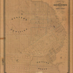
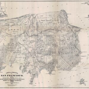
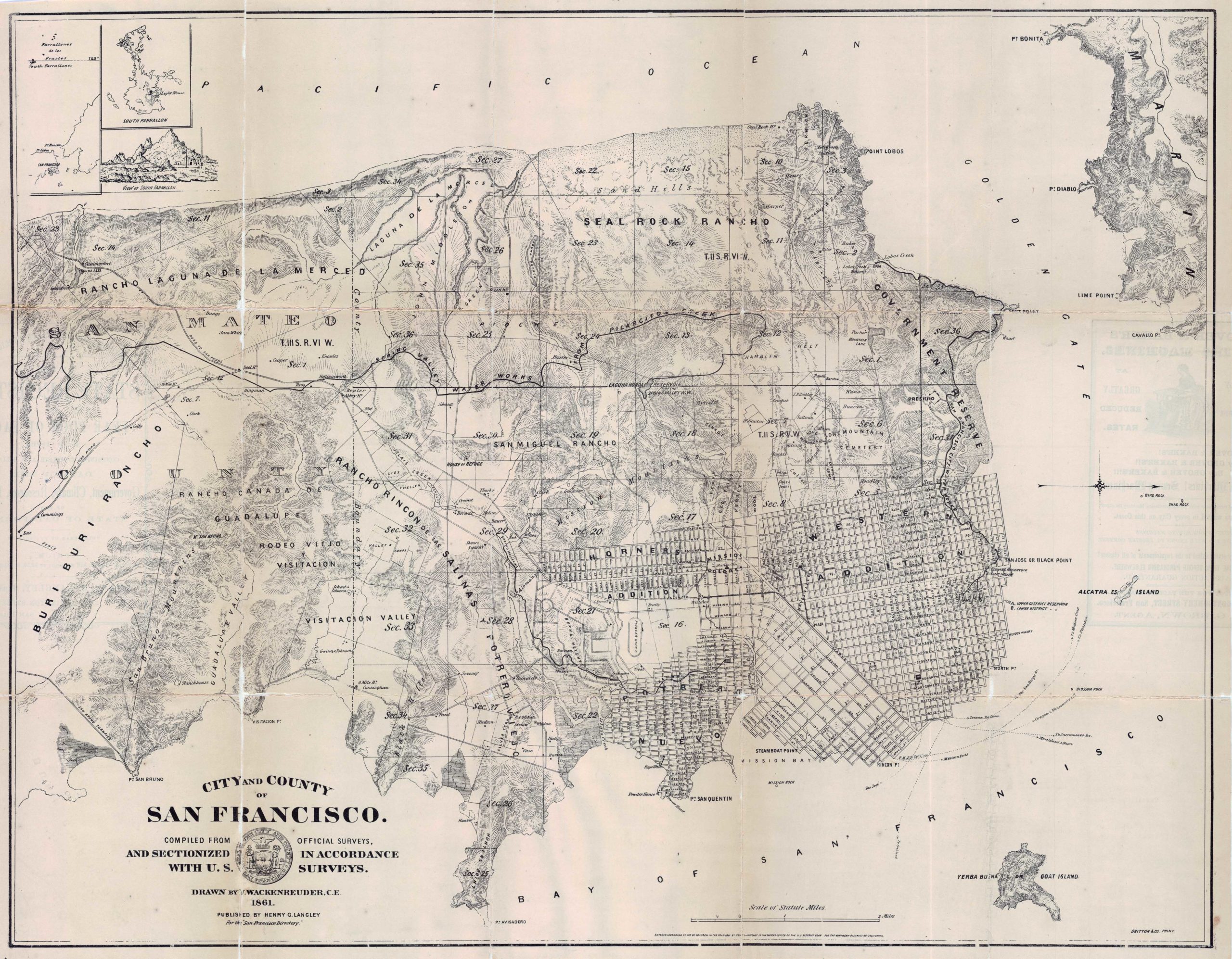
City and County of San Francisco compiled from official surveys and sectioned in accordance with U.S. surveys.
- One of the most interesting and important post-Gold Rush maps of San Francisco.
- Read moreQuick View
-
- Out of Stock
- California
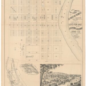
Map of Town Site and Hot Springs of El Paso de Robles.
- Likely the earliest specific map of Paso Robles.
- Read moreQuick View
-
- Out of Stock
- Bird's-eye-views, San Francisco
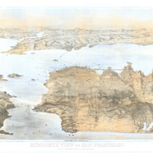
Birdseye View of San Francisco and Surrounding Country.
- Goddard’s rare and remarkable view of San Francisco, Marin, and the East Bay.
- Read moreQuick View
-
- Out of Stock
- Bay Area & Silicon Valley, California
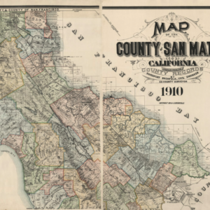
Map of the County of San Mateo California Compiled from the County Records by Davenport Bromfield, Civil Engineer, Ex-County Surveyor, 1910.
- Before Silicon Valley: a stunning, large-scale 1910 map of San Mateo County.
- Read moreQuick View
-
- Out of Stock
![[With Municipal Report] Montgomery Avenue: Showing the land condemned, buildings destroyed, frontage on each block, profile of grade, and district to be assessed.](https://neatlinemaps.com/wp-content/uploads/2023/01/Screen-Shot-2023-01-04-at-12.33.00-PM-300x300.png)
- San Francisco
[With Municipal Report] Montgomery Avenue: Showing the land condemned, buildings destroyed, frontage on each block, profile of grade, and district to be assessed.
- The changing face of a growing city: the creation map for Columbus Avenue, bound in its original municipal report.
- Read moreQuick View
-
- Out of Stock
- Marin, Sonoma, & Napa Valley
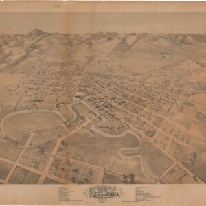
Bird’s Eye View of the City of Petaluma, Sonoma County, California.
- One of the earliest views of Petaluma.
- Read moreQuick View
-
- Out of Stock

- San Francisco
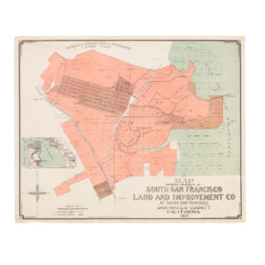
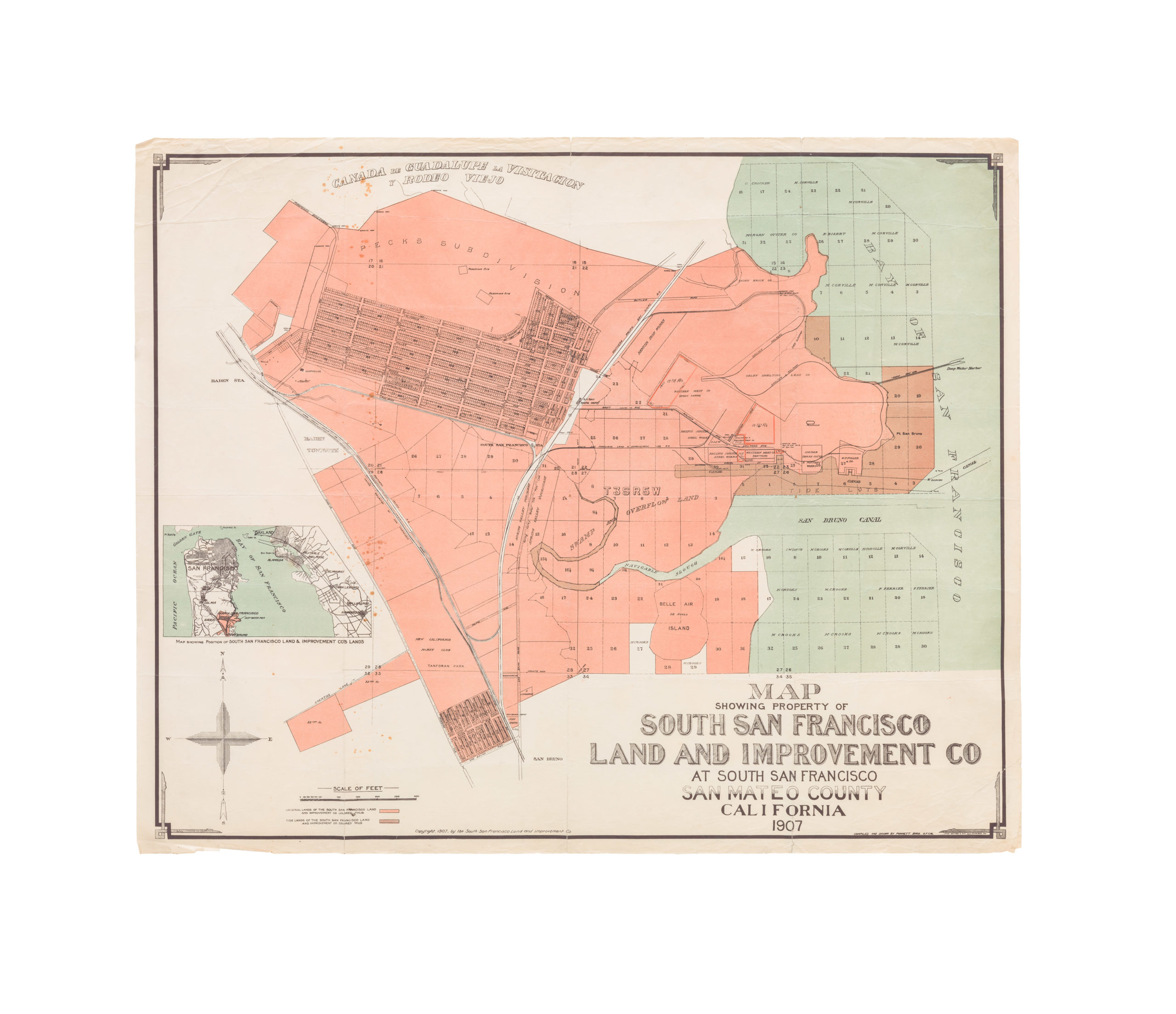
Map Showing Property of South San Francisco Land and Improvement Co at South San Francisco, San Mateo County, California
- A large-format urban plan of South San Francisco.
- Read moreQuick View
-
- Out of Stock
- San Francisco
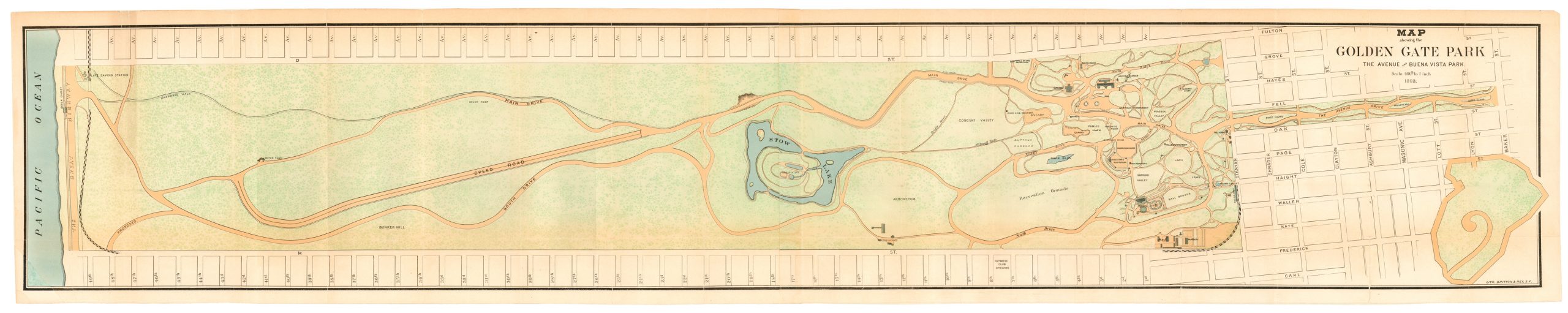
Map Showing Golden Gate Park, the Avenue and Buena Vista Park. Scale 400 ft. to 1 inch.
- This lovely early example of Britton & Rey’s iconic plan of Golden Gate Park is an anchor of San Franciscan identity: It speaks to us about origins and progress, urban renewal and civil rights, and is ultimately a testimony to the city’s grand but turbulent history.
- Read moreQuick View
-
- Out of Stock
- San Francisco
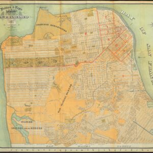
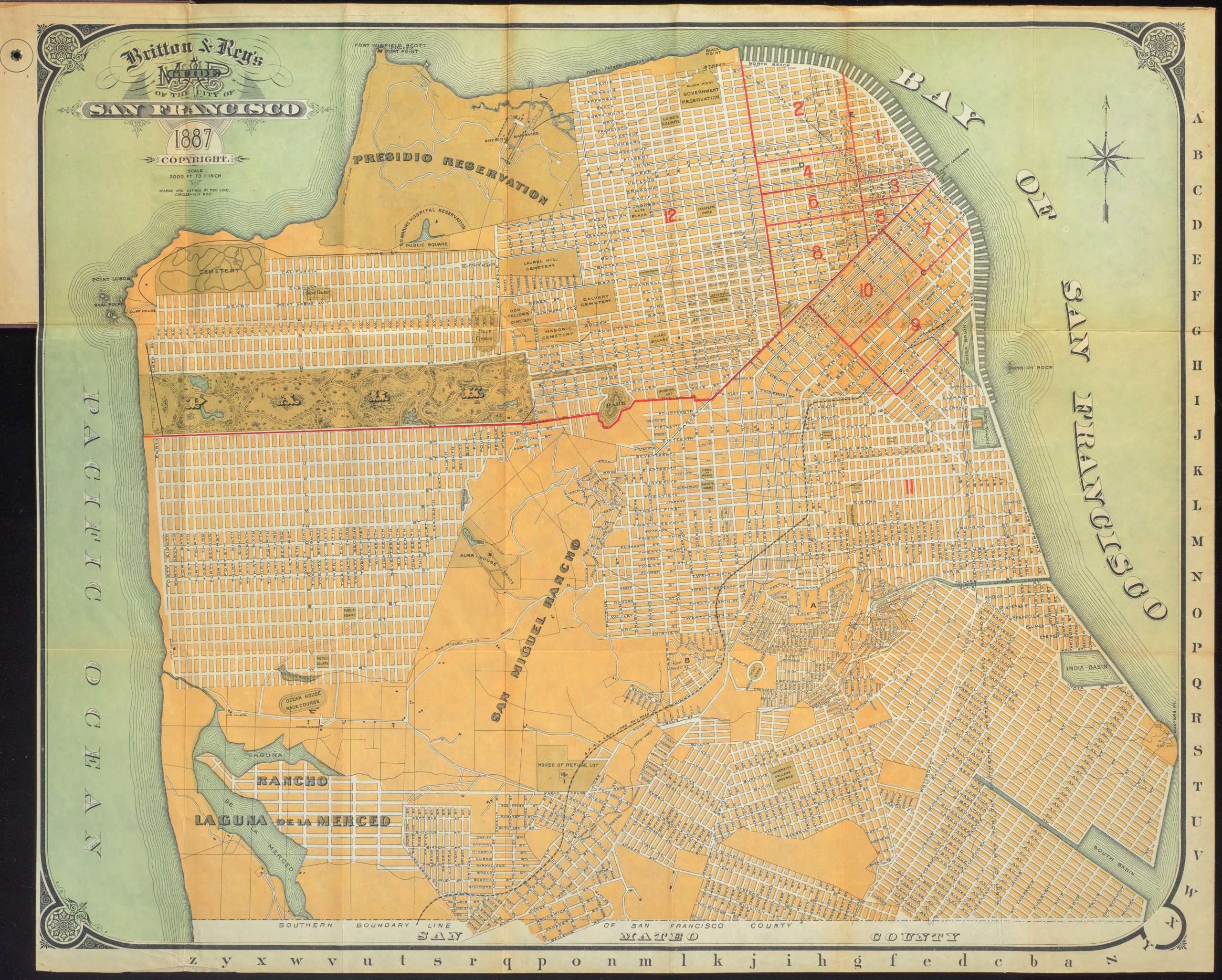
Britton & Rey’s Guide Map of the City of San Francisco. 1887. Copyright. (with) Index to Street Guide Map of San Francisco, Cal. by Britton & Rey
- Unusual 1887 Britton & Rey map of San Francisco with a rare depiction of the Bay District Racing Track.
- Read moreQuick View
-
- Out of Stock
- California
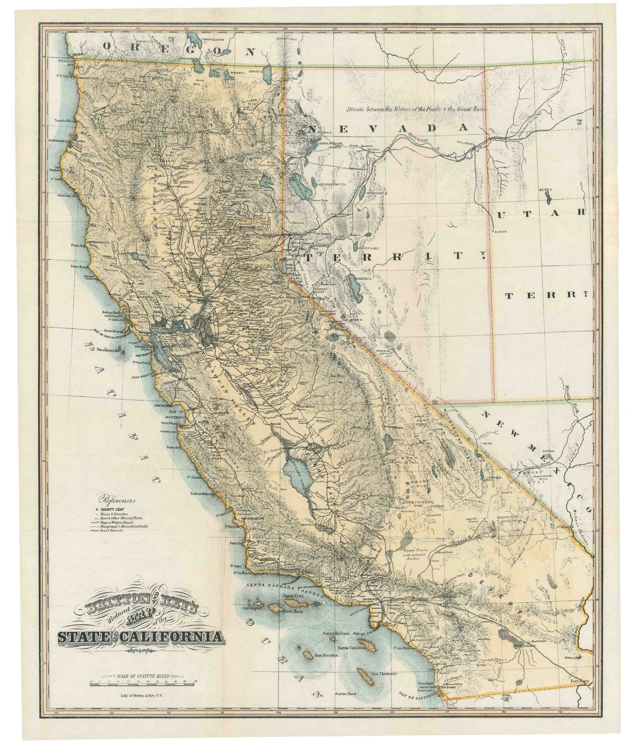
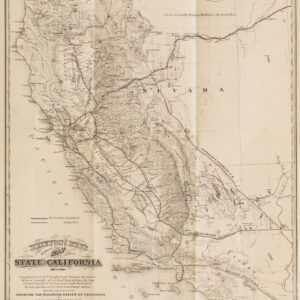
Britton and Rey’s Reduced Map of the State of California
- A lovely 19th-century map of California with up-to-date survey work, including railroads.
- Read moreQuick View
-
- Out of Stock
- San Francisco
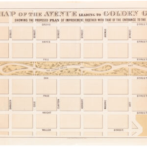
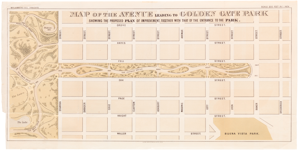
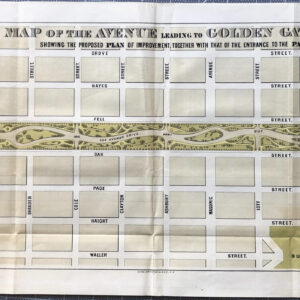
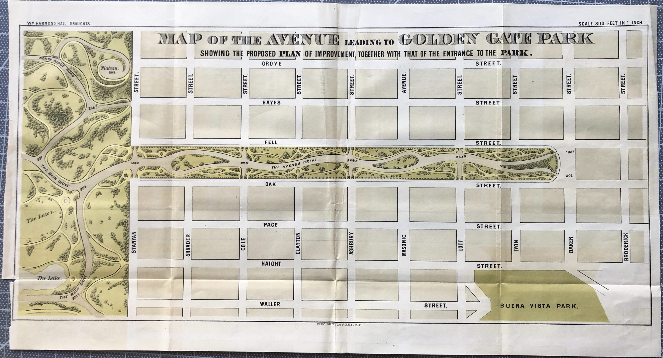
Map of the Avenue leading to Golden Gate Park Showing the Proposed Plan of Improvement, Together with that of the Entrance to the Park
- 1872 William Hammond Hall map of the Panhandle.
- Read moreQuick View
-
- Out of Stock
- Featured Maps & Views, San Francisco
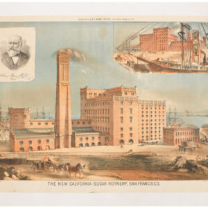
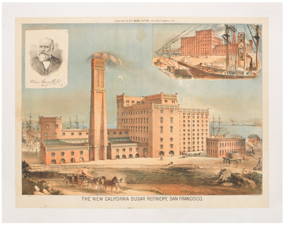
The New California Sugar Refinery, San Francisco.
- The New California Sugar Refinery: an emblem of late 19th century industrial San Francisco.
- Read moreQuick View
-
- Out of Stock
- Bay Area & Silicon Valley, San Francisco
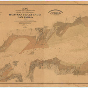
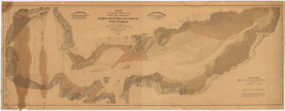
Map Exhibiting the Salt Marsh, Tide and Submerged Lands Disposed of by the State of California in and Adjacent to the Bays of San Francisco and San Pablo and now Subject to Reclamation Prepared from Maps of the U.S. Coast Survey & Official Records by Order of the Board of State Harbor Commissioners for the United States Commissioners on San Francisco Harbor…
- The power of private enterprise in America: a rare and important map of the San Francisco Bay Tide Lands, showcasing ambitions behind the city’s development.
- Read moreQuick View
-
- Out of Stock
- San Francisco
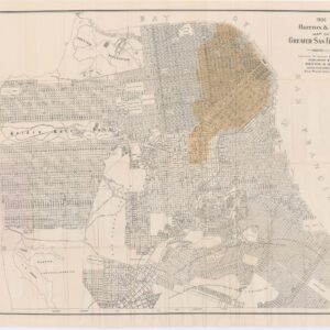
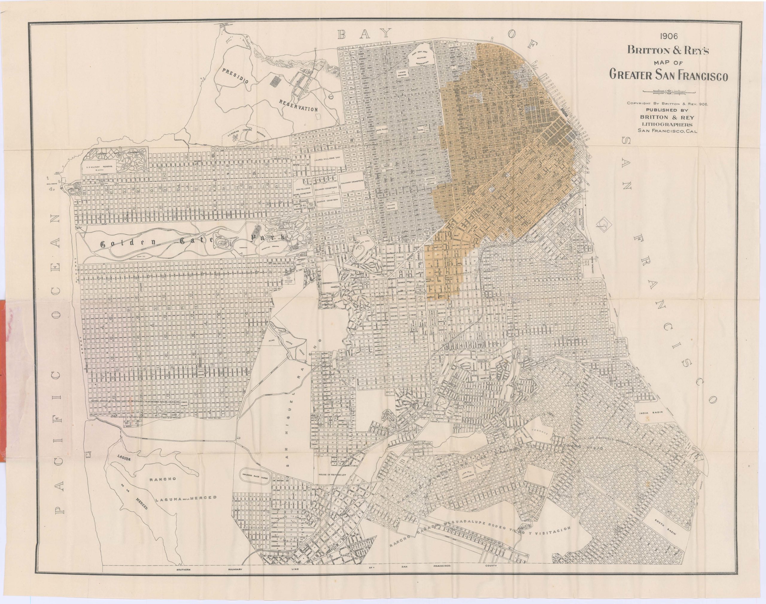
1906 Britton & Rey’s Map of Greater San Francisco Showing Burned District
- Unrecorded map of the destruction in San Francisco, published soon after the earthquake and fire.
- Read moreQuick View
-
- Out of Stock
- Marin, Sonoma, & Napa Valley
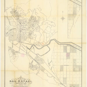
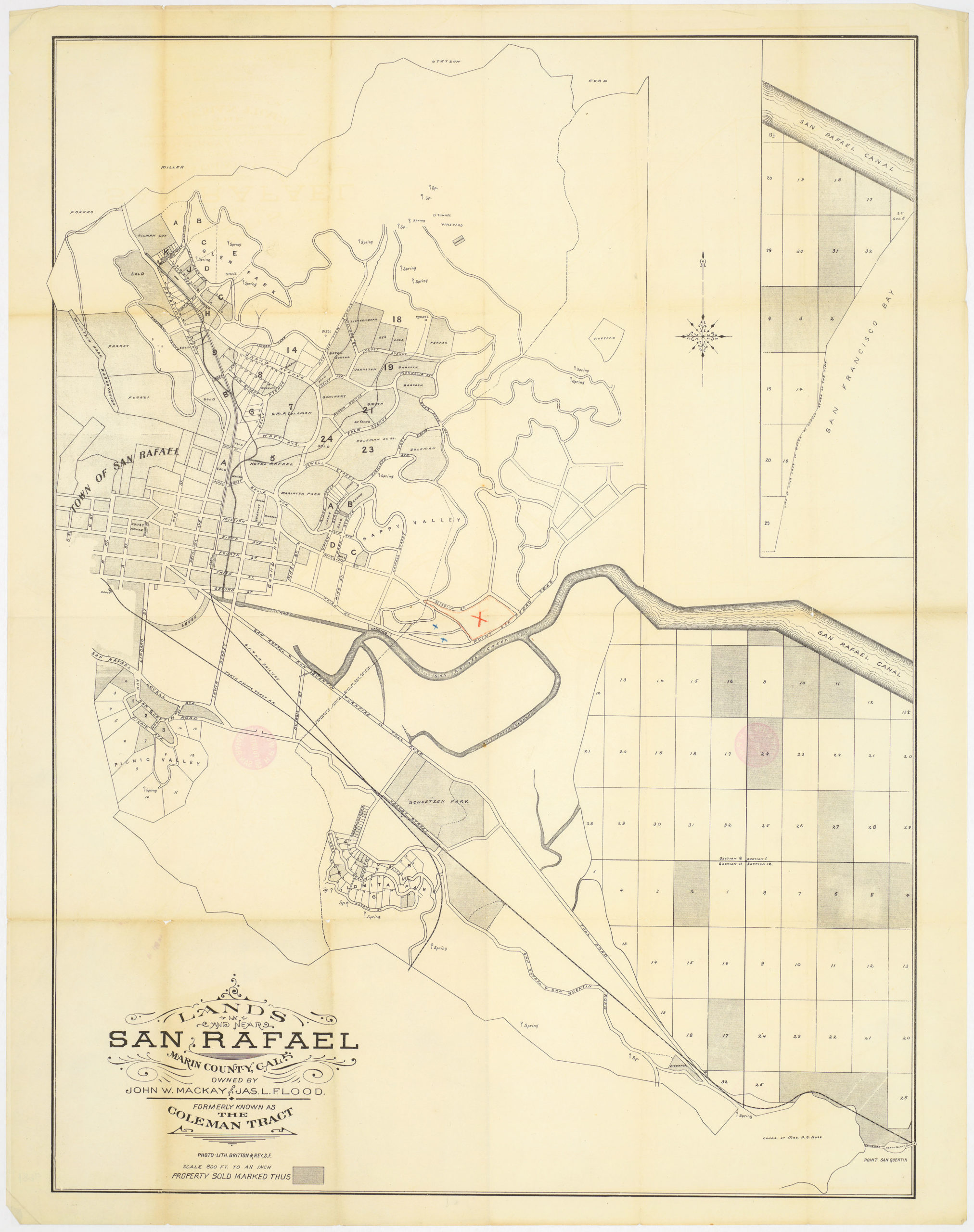
Lands In and Near San Rafael Marin County Cal. Owned by John W. Mackay and Jas. L. Flood. Formerly known as the Coleman Tract
- A rarity of Marin County: 19th century San Rafael silver baron map.
- Read moreQuick View
-
- Out of Stock
- San Francisco
Map of the avenue leading to Golden Gate Park showing the proposed plan of improvement, together with that of the entrance to the park
- Golden Gate Park takes shape: 1872 map of the Panhandle by William Hammond Hall.
- Read moreQuick View
-
- Out of Stock
- Bay Area & Silicon Valley, San Francisco
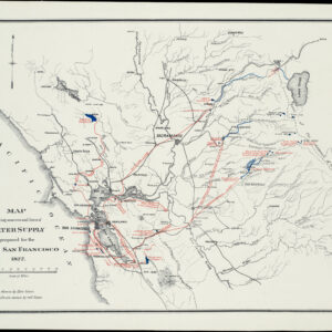
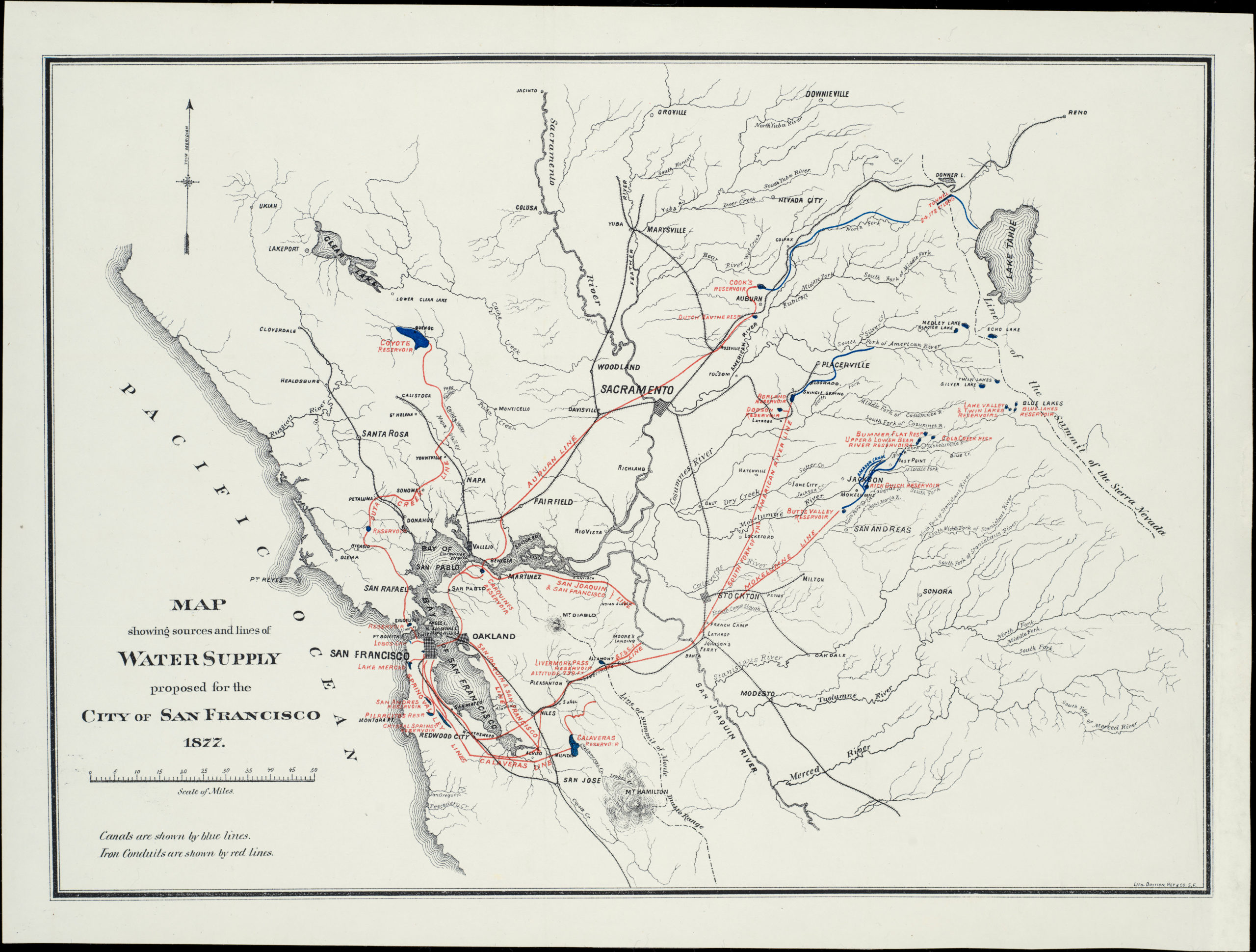
Map showing sources and lines of Water Supply proposed for the City of San Francisco 1877
- Sustaining a growing city - detailed proposal map for supplying water to San Francisco.
- Read moreQuick View
-
- Out of Stock
- San Francisco
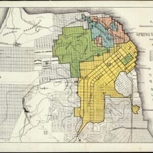
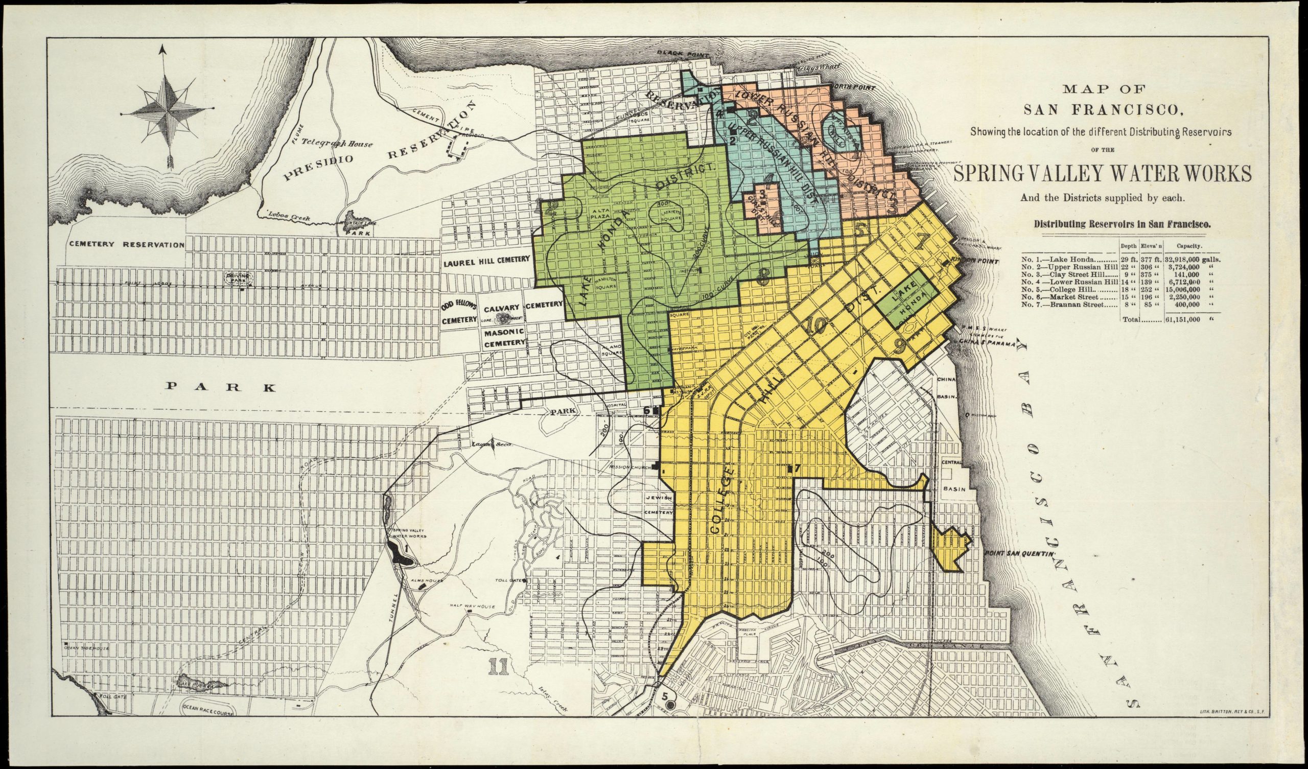
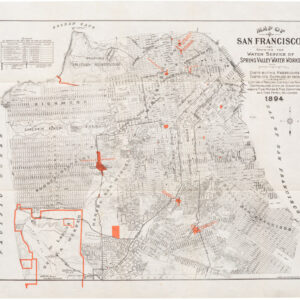
Map of San Francisco, Showing the location of the different Distributing Reservoirs of The Spring Valley Water Works And the Districts supplied by each.
- Where different San Francisco neighborhoods get their water - Spring Valley Water Works reservoir distribution map.
- Read moreQuick View
-
- Out of Stock
- San Francisco
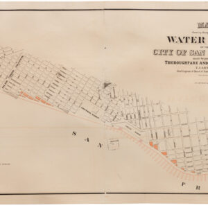
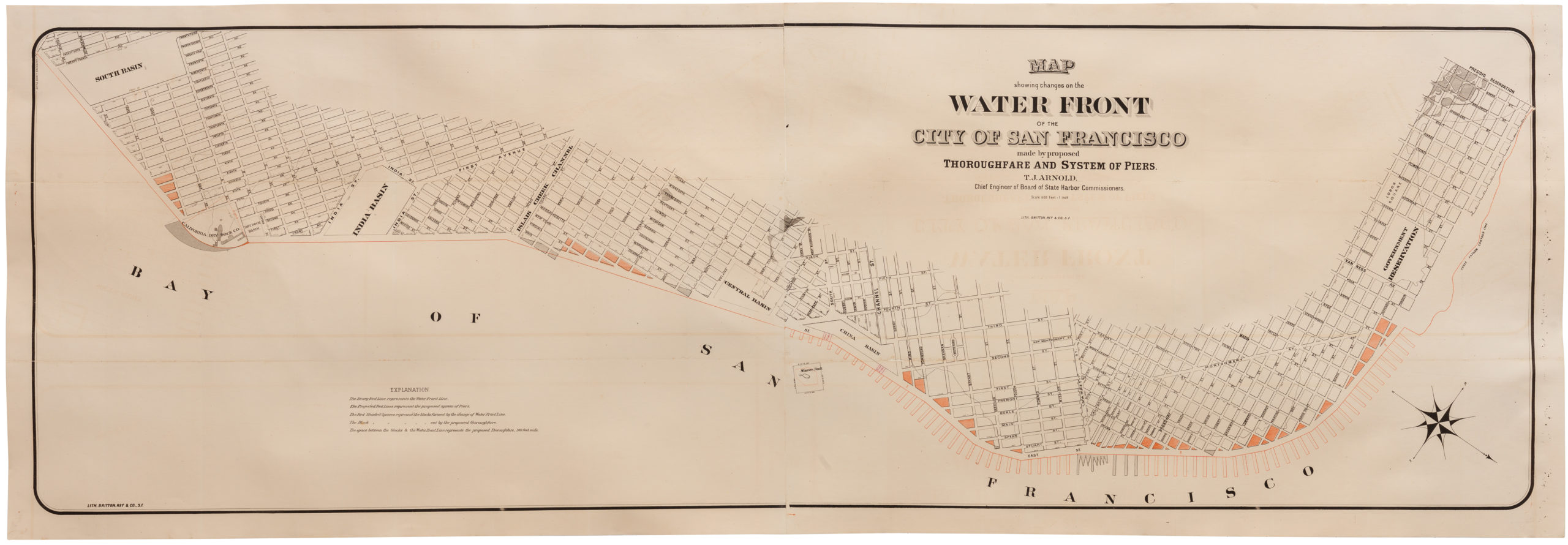
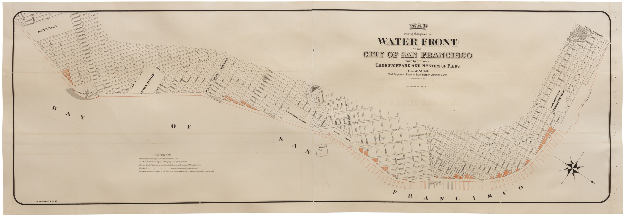
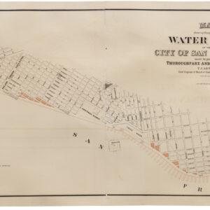
Map showing changes on the Water Front of the City and County of San Francisco made by proposed Thoroughfare and System of Piers. T. J. Arnold. Chief Engineer of Board of State Harbor Commissioners.
- Constructing San Francisco’s Embarcadero - 1877 map of proposed changes to the waterfront.
- Read moreQuick View
-
- Out of Stock
- San Francisco
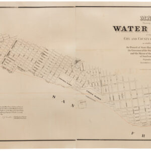
Map Showing the Water Front of the City and County of San Francisco. as established by the Board of State Harbor Commissioners, the Governor of the State of California, and the Mayor of the City & County of San Francisco. September 12th, 1877.
- Large 1877 map of the San Francisco waterfront.
- Read moreQuick View
-
- Out of Stock
- California
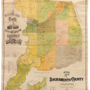
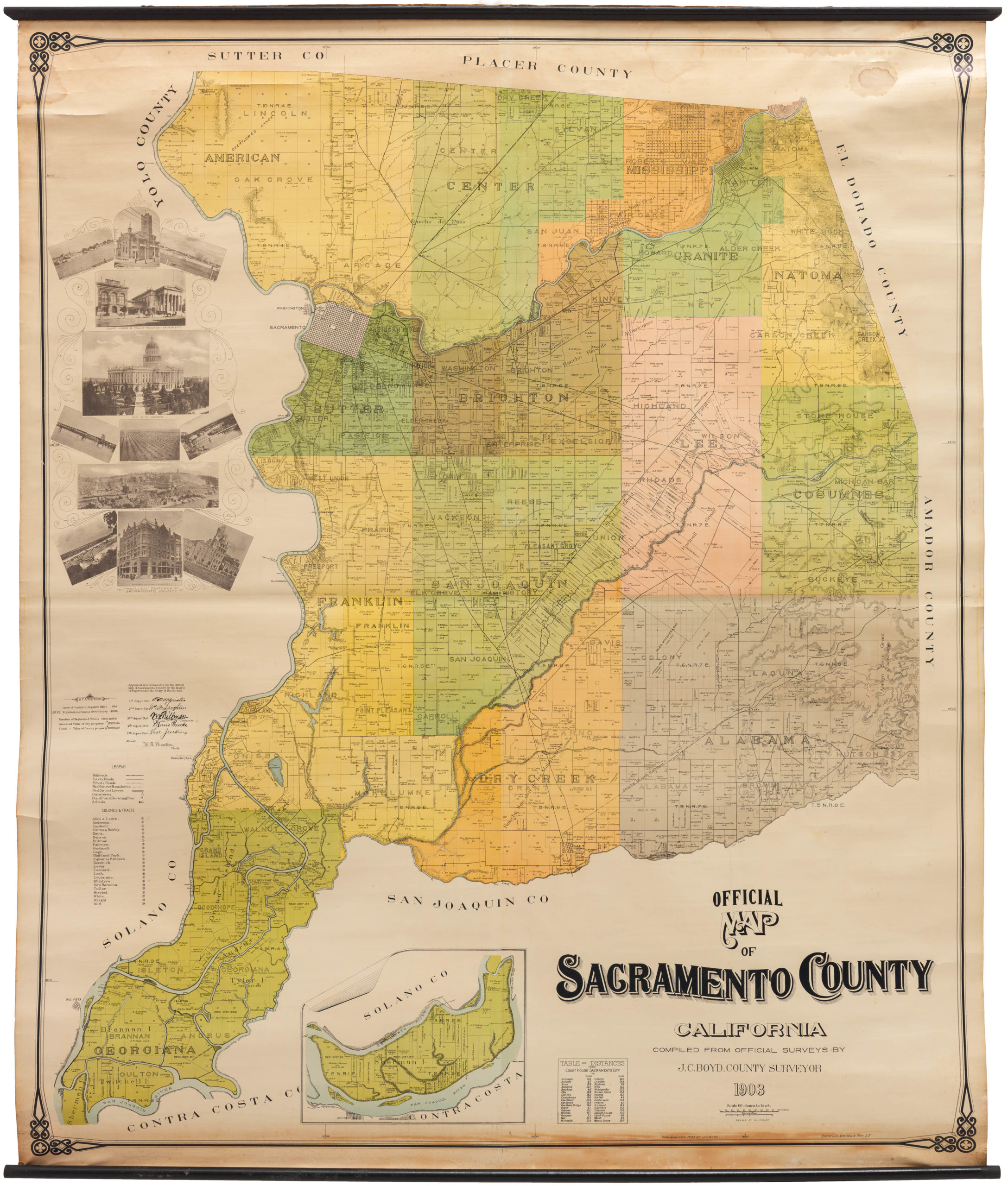
Official Map of Sacramento County, California. Compiled from Official Surveys by J. C. Boyd, County Surveyor. 1903
- Fabulous turn-of-the-century property map of Sacramento County.
- Read moreQuick View
-
- Out of Stock
- San Francisco
Map Of San Francisco Showing The Water Service Of Spring Valley Water Works. Distributing Reservoirs, Districts Supplied By Each And Location Of Principal Distributing Mains, Contour Lines, Showing Elevation Above Water & Fire Department And Fire Patrol Buildings.
- Important pre-1906 earthquake water system map of San Francisco.
- Read moreQuick View
-
- Out of Stock
- San Francisco
City and County of San Francisco compiled from official surveys and sectioned in accordance with U.S. surveys
- Rare 1861 first edition of Wackenreuder's famous map of San Francisco.
- Read moreQuick View
-
- Out of Stock
- San Francisco
Map Showing Property of South San Francisco Land and Improvement Co at South San Francisco, San Mateo County, California
- Detailed 1907 Britton & Rey lithograph of South San Francisco.
- Read moreQuick View
-
- Out of Stock
- California
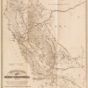
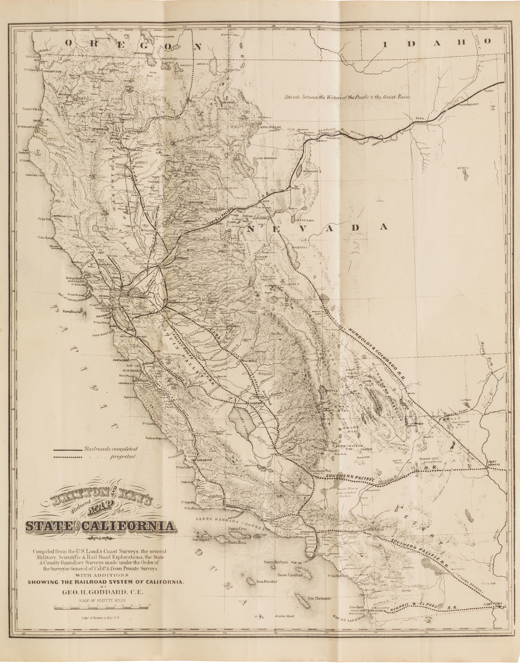
Britton & Rey’s Reduced Map of the State of California…With Additions Showing the Railroad System of California
- Britton & Rey 1871 railroad map of California.
- Read moreQuick View
-
- Out of Stock
- San Francisco
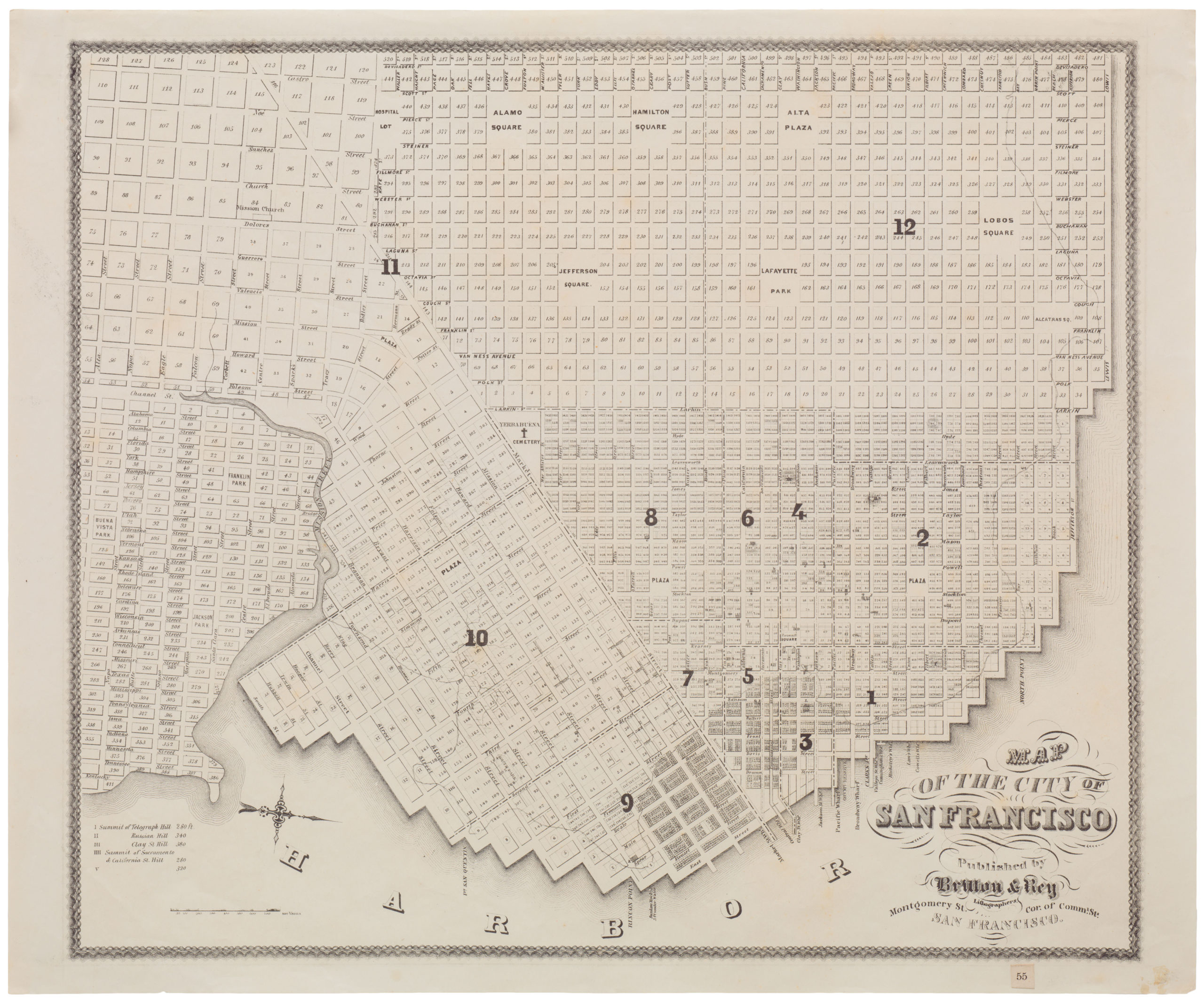
Map of the City of San Francisco Published by Britton & Rey
- Never-folded mid-19th century map of San Francisco by Britton and Rey.
- Read moreQuick View
-