Goddard’s rare and remarkable view of San Francisco, Marin, and the East Bay.
Birdseye View of San Francisco and Surrounding Country.
Out of stock
Description
A stunning panorama of with profound historical significance and a unique artistic perspective.
One of the most desirable 19th-century views of San Francisco on the market.
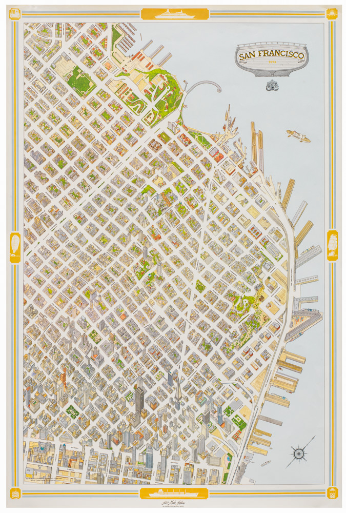
This extraordinary bird’s-eye-view provides a sweeping panorama of the entire Bay Area, looking east from a vantage point above the Pacific Ocean. The view was created by George Henry Goddard, a renowned artist, surveyor, and cartographer based in San Francisco.
Goddard’s artistic vision was characterized by a special technique in which a balance of foreshortening and exaggeration was employed to provide unique perspective. The result is lifelike and engaging, lifting his portrayal above and beyond a simple urban vista. The cityscape of San Francisco takes center stage, showcasing its bustling harbor and expansion into the hilly heart of the peninsula. Unlike conventional bird’s-eye-views, Goddard’s technique not only allowed for an impressive scope but also made his perspective dynamic and engaging, distinguishing his work from that of his peers and competitors.
Post-Gold Rush San Francisco
San Francisco developed from the sleepy town of Yerba Buena to a cosmopolitan metropolis in just a few short years. In addition to the U.S. capture of this region during the Mexican-American War, the main reason for San Francisco’s boom was the discovery of gold at Sutter’s Mill and the ensuing Gold Rush of 1849. Urban growth was rapid, and by the 1870s, San Francisco boasted a population of almost a quarter million people. It is this bustling era of the thriving West Coast port that Goddard captures in his view. Scores of ships are waiting to be loaded or unloaded along San Francisco’s waterfront, just as many vessels are braving the strong currents of the Golden Gate.
The orthogonal layout of the city itself reveals not only the bustling nature of San Francisco but also speaks to its rapid and planned growth. Most prominent within this massive grid of streets is the diagonal thoroughfare of Market Street. Cutting more than three miles across the city and connecting the waterfront (Embarcadero) with the interior hills of the peninsula (i.e., modern Twin Peaks), this was one of San Francisco’s oldest and most important streets. It was laid out as early as 1847, within months of the U.S. annexation of Yerba Buena, and is delineated in the 1847 survey of emigré and civil engineer Jasper O’Farrell.
The downtown area is meticulously rendered so individual buildings can be identified amidst the bustling urban landscape. As one’s eye moves west, out of the densely developed area, iconic San Francisco landmarks such as the Presidio Military Reservation barracks and the nascent Golden Gate Park stand out clearly. Notably, the iconic Golden Gate Strait connecting the Bay to the Pacific Ocean graces the lower left corner, adding to the grandeur.
Beyond San Francisco
Goddard’s view captures much more than just a booming San Francisco: it is a vibrant testament to the evolution of the entire Bay Area in the 19th century. Across the Bay, we see Oakland, which during the 1870s grew to become the Bay Area node that connected San Francisco to the continental part of the country. Oakland was selected as the western terminus of the Pacific Union Railroad and has functioned as such since 1869. This role facilitated its growth as a commercial hub.
Goddard’s panoramic view also extends south, down to a rapidly evolving San Jose, which had been selected and incorporated as California’s first state capital in 1850. While the stretch between San Francisco and San Jose today is one of the most densely inhabited in the world, this whole region remained largely agrarian when Goddard composed his view. This, too, would soon change, starting with the foundation of Stanford University in 1885 and the subsequent establishment of new neighborhoods along the Santa Clara Valley (e.g., Palo Alto and Silicon Valley).
To the north, or on the left side of the view, we note the southern tip of Marin County, including emergent towns like Sausalito and San Rafael. Angel Island figures prominently at the end of Richardson Bay. A railroad line runs from Sausalito north past today’s Strawberry Point and Blackie’s Pasture. Another railroad connects San Quentin and San Rafael. Further inland, Vallejo and the large San Pablo Bay complete the panorama, and in the distance, the vista is framed by the majestic peaks of the Sierra Nevadas.
Census
Goddard’s view of San Francisco and the Bay Area was hugely popular and consequently published in at least seven distinct states between 1868 and 1880:
1. Dated 1868: Published by Snow & Roos, 21 Kearney St. S.F.
2. Dated 1868: Published by Snow & Roos, San Francisco
3. Dated 1868: Published by Snow & May, San Francisco
4. Dated 1868: Snow & Roos (copyright)
5. Dated 1875: Published by Snow & May, 21 Kearney St. S.F.
6. Dated 1876: Snow & Roos (San Francisco)
7. Dated 1880: Snow & May, S.F. Republished in 1880 by Snow & Co. 20 Post Street, S.F.
Neatline’s example of Goddard’s view constitutes the 7th and final state, published by Snow & May in 1880.
The rarity of this view is underscored by its limited presence in institutional collections in America. The OCLC records no examples of the 1st to 5th state in institutional collections, and only four examples of the sixth state, published in 1876 (no. 5447325): Library of Congress, University of California Davis, Pennsylvania State University, and the DeGoyler Library at Southern Methodist Uni in Texas.
Cartographer(s):
Britton & Rey (1852 – 1906) was a lithographic printing firm based in San Francisco and founded by Joseph Britton and Jacques Joseph Rey in 1852. Especially during the second half of the 19th century, Britton and Rey became the leading lithography firm in San Francisco, and probably California. Among their many publications were birds-eye-views of Californian cities, depictions of the exquisite landscapes, stock certificates, and no least maps. While Rey was the primary artist, Britton worked not only as the main lithographer but was essentially also the man running the business. In addition to their own material, the firm reproduced the works of other American artists like Thomas Almond Ayres (1816 – 1858), George Holbrook Baker (1824 – 1906), Charles Christian Nahl (1818 – 1878), and Frederick August Wenderoth (1819 – 1884). Following Rey’s death in 1892 Britton passed the form on to Rey’s son, Valentine J. A. Rey, who ran it until the great earthquake and fire of 1906 destroyed most of the company’s assets.
Joseph Britton (1825 – July 18, 1901) was a lithographer and the co-founder of the prominent San Francisco lithography studio Britton and Rey. He was also a civic leader in San Francisco, serving on the Board of Supervisors and helping to draft a new city charter. In 1852, he became active in lithography and publishing, first under the name ‘Pollard and Britton,’ and then ‘Britton and Rey,’ a printing company founded with his friend and eventual brother-in-law Jacques Joseph Rey. Britton and Rey became the premier lithographic and engraving studio of the Gold Rush era, producing letter sheets, maps, and artistic prints.
Jacques Joseph Rey (1820 – 1892) was a French engraver and lithographer born in the Alsatian town of Bouxwiller. At the age of about 30, he emigrated to America, eventually settling in California. Here, he soon entered into a partnership with local entrepreneur and civic leader Joseph Britton. Three years later, Rey also married Britton’s sister, allowing his business partner and brother-in-law Britton to live in their house with them. Rey and Britton were not only an important part of the San Francisco printing and publishing scene but also owned a plumbing and gas-fitting firm. In the early years, both men would sometimes partner up with others on specific projects, but by the late 1860s, their partnership was more or less exclusive.
George E. GoddardGeorge Henry Goddard (1817-1906) was an accomplished artist and civil engineer who played a pivotal role in California’s early history. Originally from England, he ventured to California during the height of the Gold Rush, initially seeking fortune in the goldfields. His transition to professional surveying soon entailed working for the California government and winning lucrative contracts from railway and mining companies. This work, in turn, led to significant contributions in cartography, including notable publications such as Britton & Rey’s Map Of The State Of California (1857).
In recognition of his groundbreaking work in surveying the Sierra Nevada, one of the range’s highest peaks (13,564 feet) was named ‘Mount Goddard’ after him in 1864. His later move to San Francisco saw the creation of several iconic representations of the city and its surroundings, etching his name into San Francisco’s historical legacy.
Throughout his adult life, Goddard diligently collected historical objects and documents pertaining to California. Stanford was planning on building a museum for his collection when it was destroyed in the fires following the 1906 San Francisco Earthquake. While Goddard himself survived the conflagration, the calamity took such a toll that he died a few months later.
Snow & MayCondition Description
Gorgeous coloring. Flattened with folds reinforced on verso, repairs to minor separations at folds.
References